Black Hills, SD & WY Expedition No. 205 – Balm of Gilead Gulch & Cement Ridge (5-20-17)

Start, 11:04 AM, 33°F, intersection of USFS Roads No. 189, 189.4A & 631.2C about 0.33 mile WSW of Crooks Tower

This was supposed to be an expedition to celebrate the rapid approach of a glorious new summer!  Lupe would explore mysteriously named Balm of Gilead Gulch before continuing on to Cement Ridge.  There, beneath cotton ball clouds sailing a crystal blue sea, the Carolina Dog would sniff colorful wildflowers swaying in warm breezes.  She would gaze upon panoramic views of Inyan Kara, the Bear Lodge Mountains, and far into eastern Wyoming.

The scene would both excite the imagination and serve as a call to action!  Nearly 8.5 months after Lupe’s return from her grand Summer of 2016 Dingo Vacation to the Canadian Rockies, Yukon & Alaska, the time for new Dingo adventures beyond the Black Hills was almost here!

Hah!  Dream on.  Even before leaving home, SPHP knew the forecast didn’t include much in the way of warm breezes.

A week ago on Expedition No. 204, Lupe had visited Crooks Tower (7,137 ft.), one of the highest points in the Black Hills.  She’d made a day of it coming up from Merow Spring and Clayton Pond, and subsequently continuing on to Peak 6820.  Now, driving W on South Rapid Creek Road (USFS Road No. 231), it occurred to SPHP that Loop was very close to Crooks Tower again.  Why not go back for a good look at how much conditions had changed?

It wasn’t necessary to spend a whole day on foot and paw to get to Crooks Tower.  In fact, a 2 mile detour S on USFS Road No. 189 would bring Lupe to a point only 0.33 mile WSW of the summit.  Let’s do it!  SPHP made the turn.  Five minutes later, Lupe sprang out of the G6 into a world where the mood was better suited to Rudolph the Red-Nosed Reindeer than 4th of July fireworks.

Sooooo, let me get this straight. We’re here to celebrate the imminent approach of summer, right? Did you get a really big discount for booking early SPHP, or what? At the W end of USFS Road No. 189.4A. Photo looks SSE.

Although the forecast called for 0% chance of precipitation, the sky was heavily overcast.   Any more overcast, and Lupe would have been in a fog.  Humidity filled the air.  It felt like it could rain buckets at any time.  Or snow.  At a chilly 33°F, snow seemed equally plausible.  The ground was already white with the stuff.

Lupe concealed her disappointment with summer’s non-arrival well.  In fact, she seemed thrilled and energized by the snow.  She charged through fields and forests as SPHP began a mucky march E along USFS Road No. 189.4A.

USFS Road No. 189.4A leads ENE from the junction with No. 189 & No. 631.2C. About 0.33 mile later, it passes just S of the summit of Crooks Tower. Photo looks E.

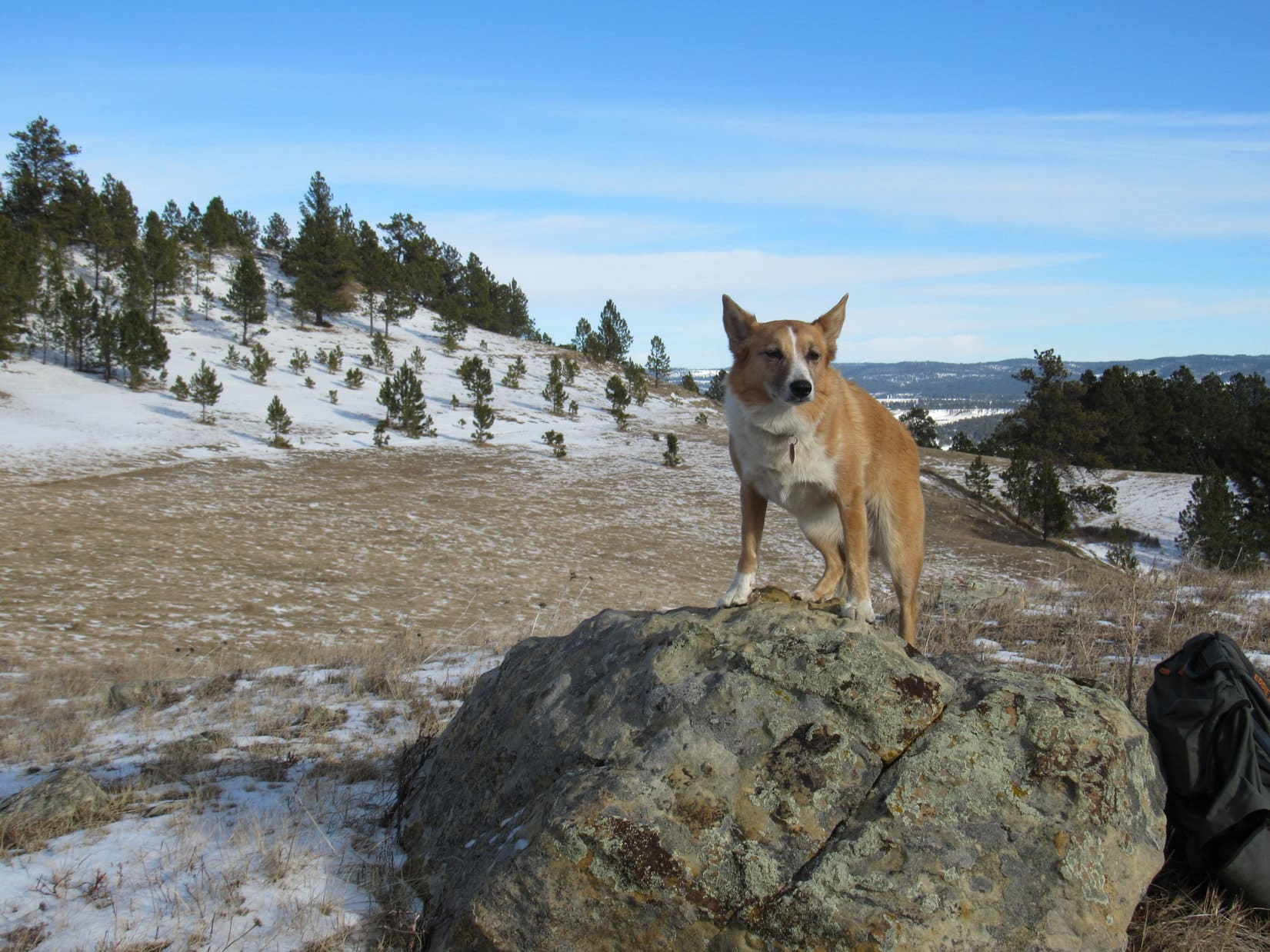
About 0.33 mile from the G6, the road passed just S of the summit of Crooks Tower.  Lupe and SPHP left the road to take the short path leading to the top from the SW.  Only a week after her 8th ascent, Lupe was here for the 9th time.

Back on Crooks Tower for the 9th time! Photo looks SE.
On the summit, looking WSW.
Each pine needle was beautifully flocked, but that wouldn’t last long this time of year. The snow already looked like it was starting to melt.
Looking NW from the summit.
Loopster at the highest point. Photo looks N.

Having been here only a week ago, Lupe and SPHP dawdled only a little while on Crooks Tower.  It was fun to be there again, but the plan was still to explore Balm of Gilead Gulch and reach Cement Ridge today.  Lupe returned to the G6 (11:35 AM, 33°F), and SPHP drove onward.

N of Highway 85, a little W of O’Neill Pass, SPHP parked the G6 again (11:53 AM, 39°F) near corrals S of the junction of USFS Roads No. 175 (Willow Springs Road) and No. 106 (Riflepit Canyon Road).  Here Lupe was only 0.67 mile W of Laird Peak (6,906 ft.), another mountain along the way.  SPHP figured she might as well climb it, too, since it was an easy peak and wouldn’t take long.

An unmarked grassy road led E from the parking area up a little valley past Tom Spring.  This area was hundreds of feet lower than Crooks Tower, so there wasn’t nearly as much snow around.  What snow there was in the pines was melting fast.  Snowmelt dripped to the ground in such abundance, Lupe was getting rained on beneath the trees.

In the valley leading E to Tom Spring on the way to Laird Peak. There wasn’t nearly as much snow here as there had been at Crooks Tower. Photo looks S.
Loop had a good time exploring on the way to Laird Peak. Photo looks E.

Tom Spring was a muddy area.  Water poured from a pipe into a circular water trough.  Not too exciting.  Lupe didn’t seem interested.  She pressed on up the valley.  The road faded somewhat beyond Tom Spring, but could still be followed.

Upon reaching a ridgeline where several better dirt roads intersected, Lupe took a road going N.  She stayed on it for only 100 feet or so to get past a fence running E/W.  She then turned E following the N side of the fence line.  Laird Peak’s summit was only a couple hundred yards ahead.  The summit appeared only as a small hill in the forest.

Approaching the summit of Laird Peak from the W. The summit appears to be just another small hill in the forest. Photo looks E.

Lupe quickly reached the top.  The summit area was easily the size of a modest yard in town and quite flat.  Deadfall timber lay scattered about the perimeter of a small clearing.  A sign marking the location of the survey benchmark was in sight near the N edge of the clearing.

Lupe at the survey benchmark on Laird Peak (6,906 ft.). A little less than half of the flat summit area is in view. Photo looks N.
This was Lupe’s 3rd ascent of Laird Peak. Other than having to deal with a little deadfall timber, it’s a quick easy climb from the W via Tom Spring. Photo looks N.
The Laird Peak survey benchmark.

Pine bark beetles had damaged the surrounding forest enough to provide tree-broken glimpses of distant views in various directions, but only enough to tantalize.  Lupe couldn’t really see much from here other than the immediate area.  With no clear views to contemplate, the American Dingo was soon ready to go.

Lupe ready to head back down the W slope. Photo looks WNW.

The sky was still overcast, but not as darkly as before.  Now and then a small patch of blue sky appeared.  SPHP kept expecting the clouds to burn off, but they didn’t.  Instead the clouds kept closing up the gaps, and the sunshine would disappear.  Nothing had really changed by the time Lupe reached the G6 again (12:45 PM).

A winding drive NW down Grand Canyon ensued.  USFS Road No. 175 turned to No. 875 at the Wyoming border.  By the time SPHP parked the G6 at the intersection of No. 875 & No. 804, it was already 1:23 PM (47°F).  If Lupe was going to explore Balm of Gilead Gulch and still have time to reach Cement Ridge, she had best get on with it.  The Carolina Dog and SPHP took off heading E up Rattlesnake Canyon on No. 804.

Dandelions prospered along No. 804 on the way up Rattlesnake Canyon. Nuisances in yards, dandelions are amazingly resilient plants.

The stroll up Rattlesnake Canyon was easy.  A couple of miles E of the G6, SPHP started looking for a R (S) turn on USFS Road No. 804.1A which would take Lupe up into Balm of Gilead Gulch.  A road going S up a hill did appear.  There weren’t any signs at the turn, but a forest service gate was in view a little way up the hill.

Was this No. 804.1A?  It didn’t seem quite right.  The topo map showed a 4WD trail heading S up a smaller valley about 0.5 mile before (W of) the turn to Balm of Gilead Gulch, and this was the first side road Lupe had come to.  SPHP almost led Lupe past this road, but decided she might as well check out the forest service gate for any clues first.

Good thing!  Nearing the gate, Lupe found a marker showing this was USFS Road No. 804.1A.

Nearing the forest service gate, Lupe found a marker showing this was USFS Road No. 804.1A after all. She was bound for Balm of Gilead Gulch! Photo looks S.

So this was it!  Lupe was bound for Balm of Gilead Gulch!  Except for one thing that raised doubts again.  As the Carolina Dog trotted past the gate, SPHP noticed large white letters on the round metal swivel housing on the L.  The letters read OLDB 05.  What did that mean?  SPHP was suspicious.

It might mean that this road had been renumbered.  USFS Road No. 805 went up Wagon Canyon 1.5 miles to the S.  Was this possibly a connecting spur, formerly known as No. 805.B?  Seemed like a possibility, but who knew?  May as well try it.  After all, the official sign did say this was No. 804.1A, which was supposed to be the road into Balm of Gilead Gulch.

Lupe continued up No. 804.1A.  The road turned SE and led up a small forested valley.  The day had warmed up some, and Lupe was still considerably lower here than she had been at either Crooks Tower or Laird Peak, so she didn’t find any snow in this area.  There had been some, though.  The road was damp, nearly muddy.

Although no tire tracks were to be seen, an amazing number of animal tracks crisscrossed the soft road.  It wasn’t long before Lupe started seeing wildlife – whitetail deer and Lupe’s giant deers – the elk.

Lupe saw many whitetail deer and a number of her giant deers (elk), too, as she traveled up USFS Road No. 804.1A.

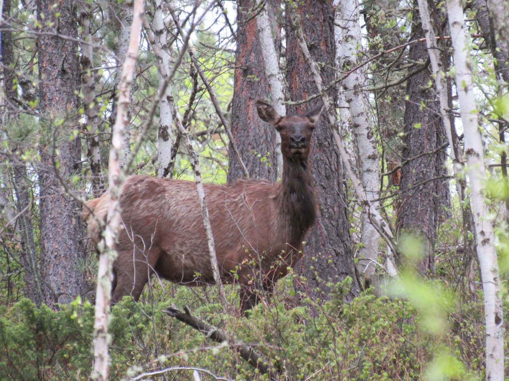
It was fun being where there were so many animals in the forest, and sort of easy to see why they were here.  No tire tracks on the road at all meant people seldom come here.  The forest was full of hidden grassy glens.  This was a good place to hide and hang out.

Lupe at a grassy glen along USFS Road No. 804.1A. There seemed to be plenty more such glens hidden back in the forest, making this area popular with deer and elk.

Lupe gained elevation steadily for perhaps a mile before the road leveled out.  Here, the main road turned SW and started going downhill.  A fainter road curved ESE.  Lupe needed to go E, so she took the fainter road.  When she wanted to stop for a water break 5 or 10 minutes later, SPHP took a look at the maps.

Hmmm.  SPHP was soon convinced that Lupe hadn’t been traveling through Balm of Gilead Gulch at all.  Where the main road had turned SW, it almost had to be headed for Kirley Gulch on its way down to Wagon Canyon.  Apparently the road numbers really had been changed.  The old No. 804.1A leading into Balm of Gilead Gulch that Lupe had been looking for was no more.  The new No. 804.1A actually was a road connecting No. 804 in Rattlesnake Canyon and No. 805 in Wagon Canyon.

The inescapable conclusion was that Balm of Gilead Gulch was 0.5 mile N or NE of where Lupe was now.  She could have gone through the forest looking for it, but that would have meant losing elevation she’d already gained.  Furthermore, she would only get to travel through part of the gulch.  Instead of doing that, SPHP decided Lupe might just as well continue on to Cement Ridge.  She could hit Balm of Gilead Gulch on the way back.

Break done, Lupe roamed happily in the forest along a series of remote USFS roads.  She traveled E or SE, and once in a while NE.  She was generally still gaining elevation, but at a slow rate.  Sometimes there were markers at the road junctions, but even when there were, usually only one road was marked.  It wasn’t always clear which road the marker was meant for.

This was pretty high country, but due to the forest, Lupe seldom had any distant views.  Some ridges did eventually appear off to the S and SW.  Loop was already nearly as high as they were.

Roaming the back roads on the way to Cement Ridge. Photo looks E.
The light green of the newly emerging aspen leaves contrasted nicely with the dark green of the Ponderosa Pines. Lupe loves wandering back roads like this one. Photo looks ESE.
This was a 3 way intersection (roads also went to the L & R) where Lupe found a marker for USFS Road No. 805.3J, but which road it was meant for was impossible to tell. She had reached this point coming up the road seen on the R. Photo looks W.

On her explorations, Lupe either traveled along or passed by USFS Roads No. 805.3J, 805.3G, and 805.3A.  About two miles E of where she’d left No. 804.1A, she came down a side road marked No. 105.1B to arrive at the first major gravel road she’d seen since leaving No. 804 down in Rattlesnake Canyon.

A check of the maps revealed that Loop was now only 0.25 mile S of No. 105’s junction with No. 804.  Cement Ridge (6,674 ft.) was only 1.5 miles NNW beyond the intersection.  Before setting out again, Lupe was ready for more water and Taste of the Wild.  SPHP ate the only apple, which was supposed to have been saved for Cement Ridge, but, oh well.

All tanked up again, Lupe set off along No. 105 for Cement Ridge.  Upon reaching the junction with No. 804, she followed No. 804 NNW a good 0.5 mile to its high point, then plunged into the forest.  The American Dingo loves being off road most of all, so she had a grand time.  Gradually things got steeper, but it was never more than a straightforward trudge up a hill.

When Lupe reached the ridgeline along the N face, she turned W and followed the ridge a short distance to a pathetic little limestone cairn at the high point.  This was it, the true summit of Cement Ridge!

Lupe next to the pathetic little limestone cairn at the true summit of Cement Ridge. Photo looks WNW.
Crow Peak is seen faintly on the horizon beyond Lupe. The sky was still cloudy and rather hazy. Loop found a small amount of snow remaining here on Cement Ridge, but only close to the true summit. Photo looks NE.

Virtually no one from the Black Hills region would recognize this place where Lupe was now as the summit of Cement Ridge.  This might be the true summit according to the topo maps, but only a handful of peakbagging Dingoes would even be aware of its existence.  Cement Ridge is well known locally as one of the Black Hills’ premier viewpoints, but what everyone around here is referring to are the views from the Cement Ridge fire lookout tower.

The fire lookout tower is located on a barren highpoint near the NW end of Cement Ridge over a mile from the true summit.  According to the topo map, the lookout tower is 27 feet lower than the true summit.  Nevertheless, the views from the tower are far superior to those available from the heavily forested true summit.

Lupe could see the lookout tower from the true summit.  Perhaps it was only an illusion, but it actually looked higher to SPHP.

The Cement Ridge fire lookout tower (L) was visible from the cairn where the true summit is supposed to be. SPHP thought the lookout tower actually appeared higher, but perhaps its an illusion. Lupe offered no opinion. Photo looks NW.

Lupe had no comment on which point she thought might be highest, the lookout tower or this pathetic little cairn.  She was content to let surveyors battle that one out.  However, when SPHP asked if she wanted to go see the fabulous views at the tower, she was all for that!

A 10 minute trek N down through an aspen forest brought Lupe to a saddle where USFS Road No. 850 coming up from the W turns N.  Loop followed the road all the way to the lookout tower.  Not a soul was around.

Lupe reaches the Cement Ridge Lookout Tower. Photo looks E.
This survey benchmark is located at the base of the flag pole NW of the lookout tower.
The Cement Ridge fire lookout tower in eastern Wyoming is only 1 mile W of the South Dakota border. The true summit is even closer to South Dakota, only 0.5 mile away.

Instead of cotton ball clouds sailing a crystal blue sky, Lupe saw scattered tiny patches of blue lost in a gray-white ocean.  She felt no warm breezes.  There were wildflowers to sniff, but they tossed about tormented by a chilly N breeze.  The views were wonderful, but felt remote and forlorn, not bright and inspiring.

Looking SE along the length of Cement Ridge. The access road is seen below. The true summit (R) is the high point in the distance appearing almost straight up from Lupe’s head.
Inyan Kara (6,360 ft.) (R) from Cement Ridge. Photo looks SW with help from the telephoto lens.
George Armstrong Custer reached the summit of Inyan Kara on July 23, 1874, less than 2 years before his death in the Battle of the Little Bighorn (Custer’s Last Stand) on June 25-26, 1876 in Montana. Lupe reached the summit on November 9, 2014, more than 140 years after Custer.
Crow Peak (5,787 ft.) (R) is the most prominent peak W of Spearfish, SD. Photo looks NNE.
Looking NW toward the Bear Lodge Mountains. Warren Peaks (6,650 ft.) is the high point where another fire tower exists.

With sweeping views in nearly all directions, Lupe saw a great many Black Hills peaks she had been to before.  The wind was coldest and strongest, though, up near the fire tower.  Lupe and SPHP retreated a bit down the W slope to an old picnic table.  Conditions were only slightly better here, and only the views to the W could still be seen, but they were grand.

Looper and SPHP stayed at the lower picnic table soaking it all in.

Loopster up on the old picnic table. Inyan Kara is on the horizon to her R. Photo looks SW.
Warren Peaks again. Lupe made a number of expeditions to peaks in the Bear Lodge Mountains in the fall of 2016. Photo looks NW.
Looking E back toward the lookout tower from the lower picnic table. Two newer picnic tables were located up close to the tower.

Cement Ridge would be a great place to see the sunset, but Lupe was here too early for that.  The sun wouldn’t set for another couple of hours.  Even if she waited, the sky was so overcast, it wasn’t likely she would see much.  Besides, if she was ever going to see Balm of Gilead Gulch, she needed to get going.

Puppy ho!  After a little rest curled up beneath the old picnic table, Lupe set out for Balm of Gilead Gulch again.  The first part of the journey took her SE back along the length of Cement Ridge.  This time, instead of following the access road, she stayed up on the highest parts of the ridge where she could see the terrific views to the E.

A glance back at the Cement Ridge fire lookout tower. Photo looks NW.
Tiny wildflowers grew in profusion. These pretty little purple/pink flowers were SPHP’s favorites.
A final look back. Photo looks WNW.

On her way, since she had to pass so close to it again, Lupe returned to Cement Ridge’s true summit.

Approaching the true summit again, this time from the N. Photo looks S.
Looper returns to the true summit. She was now in a hurry to get to Balm of Gilead Gulch, so this time she didn’t dilly dally here more than a few minutes. Photo looks WNW.

Since Looper was now in a hurry to get to Balm of Gilead Gulch before the sun set, she stayed only a couple of minutes at the summit before pressing on to the S.  She came across a dirt road going SSE, which was faster for SPHP than traveling through the forest.

Going down this road, suddenly sunshine was filtering through the trees.  The sky, which had been 90%+ overcast all day long, was almost completely clear!  SPHP was astonished at how fast this transformation had taken place.  Only a few clouds remained.  The rest hadn’t floated on by, they had simply dissipated into thin air.

The sun was noticeably lower now, but would still be up for a while.  The evening light brought out even more wildlife.  Lupe saw more whitetails and giant deers.

Elk S of Cement Ridge. Photo looks SSE.

The road eventually reached USFS Road No. 105, this time a little E of its junction with No. 804.  A marker showed Lupe had been coming down USFS Road No. 105.1A.

Lupe at the marker for USFS Road No. 105.1a where it reaches No. 105. Lupe had just followed No. 105.1A SSE nearly all the way down from Cement Ridge’s true summit. Photo looks NNW.

A short trek to the W on No. 105 brought Lupe to the junction with No. 804 again.  This time she turned S on No. 105, following it back to the turn W onto No. 105.1B.

Earlier in the day, before ever reaching No. 105 on her way to Cement Ridge, Lupe had reached a broad gentle saddle where there was a 4-way intersection.  This was probably where she’d gotten on No. 105.1B as she continued E at the time.  However, SPHP had seen that the road going NW from there sloped gradually into a wide valley.  That wide valley was likely the upper end of Balm of Gilead Gulch.

With the sun getting ever lower, Lupe and SPHP hurried back along No. 105.1B, hoping to reach the broad saddle before the sun was down.  Even hurrying along, it was hard not to appreciate the beauty of the sunlight filtered by the trees.  What a wonderful evening trek!  Lupe was enthusiastic.  She raced through the forest exploring everything.

Sunlight filters through the forest nearing Balm of Gilead Gulch.

Lupe did make it to the broad saddle before the sun was down.  She turned NW on the road leading through the wide valley.  She followed the road a little way, but left it to follow a single track trail W down into Balm of Gilead Gulch.

Lupe reaches the beautiful broad valley at the upper end of Balm of Gilead Gulch. The sun wouldn’t be up much longer. Photo looks WNW.
On the single track trail after leaving the road.

Lupe traveled the entire length of Balm of Gilead Gulch, as sunlight left the valley floor to linger on the forested hillsides.  The pale golden light of day retreated to the uppermost treetops, and was lost.  Lupe saw deer.  She saw elk.  A hawk screeched and flew away.  Lower down where the valley narrowed, the Carolina Dog came to a tiny stream.

It was all beautiful, but though she sniffed and looked everywhere she could, the Carolina Dog never found it.  If a different road to a different place hadn’t been relabeled as USFS Road No. 804.1A, she would have been here much earlier and had more time.  Maybe, maybe then, she would have found it.  As it was, twilight faded, darkness descended, stars glittered in the night sky.

But Lupe never did find the fabled Balm of Gilead.  (End 9:32 PM, 32°F)


“Prophet! said I, “thing of evil! – prophet still, if bird or devil! –

Whether Tempter sent, or whether tempest tossed thee here ashore,

Desolate yet all undaunted, on this desert land enchanted –

On this home by Horror haunted – tell me truly, I implore –

Is there – is there balm in Gilead? – tell me, tell me, I implore!”

Quoth the Raven “Nevermore.”

from The Raven, Edgar Allen Poe

In Balm of Gilead Gulch

Note: The Cement Ridge fire lookout tower is accessible by road from the W or SE by following USFS Road No. 804 to No. 850.  The true summit is the hill immediately S of where No. 850 reaches a saddle on the ridgeline, and turns N to continue on to the lookout.  Another route exists from the E on USFS Road No. 103 to this same point, but requires a high clearance vehicle.

Links:

Next Black Hills Expedition                  Prior Black Hills Expedition

Want more Lupe adventures?  Check out her Black Hills, SD & WY Expeditions Adventure Index, Master Adventure Index, or subscribe free to new Lupe adventures!

Black Hills, WY Expedition No. 185 – Sweetwater Mountain (12-4-16)

N of Newcastle, Lupe and SPHP stopped at the Salt Creek Overlook.  There was a little snow here in Wyoming.  Not much, but enough to brighten the scene.  Lupe perched precariously on a guard rail post for her souvenir shot, a cliff a few feet behind her.  As soon as she heard the click of the camera, she jumped off the post.  The photo was taken into the sun, but didn’t turn out too badly.

Lupe perches precariously on the guard rail post at the Salt Creek Overlook along Hwy 85 N of Newcastle, WY. Photo looks SE.

Lupe was back in wonderful Wyoming for the last time in 2016 to complete her peakbagging tour of Black Hills peaks W of the South Dakota border.  Only one peak remained on her list – Sweetwater Mountain (6,440 ft.).

Three weeks ago, on Expedition No. 182, Lupe had climbed nearby Mount Pisgah (6,380 ft.).  There had been time enough left in the day for Lupe to climb Sweetwater Mountain, too.  However, the owner of the ranch Sweetwater Mountain is situated on couldn’t be found right away.  He suddenly showed up on an ATV, as SPHP was writing a note to leave at his house requesting permission for Lupe to be on his land.

The rancher’s name was Bart Roberts, as SPHP had learned from a trip report on Peakbagger.com written by Edward Earl, the only Peakbagger.com account holder to have previously climbed Sweetwater Mountain.  Mr. Roberts refused Lupe permission to climb the mountain.  He leased out hunting rights to the property, and didn’t want the hunters disturbed.

Would it be acceptable for Lupe to return after hunting season?  Mr. Roberts considered that for a few minutes.  Yes, that would be fine, but Lupe couldn’t come back until after elk season was over at the end of November.  SPHP could park over by the old barn.

Now it was early December.  A long stretch of much colder weather starting tomorrow was in the forecast.  If Lupe was ever going to climb Sweetwater Mountain, today was the day.

As Edward Earl’s trip report mentioned, the entrance to Mr. Robert’s ranch is 12.5 miles N of Newcastle, or 5 miles S of Four Corners, on the W side of US Hwy No. 85.  SPHP drove N from the Salt Creek Overlook until Red Butte came into view, unmistakable on the E side of the highway.  Lupe was almost to Mr. Robert’s ranch.  SPHP soon saw the mailbox on a barrel mentioned by Edward Earl.  Lupe had arrived!

Lupe arrives at the entrance to Bart Robert’s ranch on 12-4-16 ready to climb Sweetwater Mountain, having already secured permission from Mr. Roberts to do so. The old mailbox on a barrel mentioned by Edward Earl’s May 2009 trip report was still here. Photo looks NW.

As previously agreed, SPHP drove only about a mile onto the ranch, parking the G6 near an old barn (8:59 AM, 14°F).  Nearby was a light green house.  This wasn’t Bart Roberts’ personal home (already passed by on a short side road to the R on the way in), but is on his land and occupied by his brother.

SPHP parked the G6 near this scenic old barn a mile or so onto Mr. Robert’s ranch. Lupe was ready to start her climb of Sweetwater Mountain! Photo looks WNW.
Lupe on today’s road to adventure! The green gate mentioned by Edward Earl’s trip report on Peakbagger.com was standing open. Photo looks WNW.

Lupe and SPHP passed through an open green gate, starting toward Sweetwater Mountain on a dirt road.  At only 14°F, it was noticeably colder here in Wyoming than back home in South Dakota, but the day would warm up.  Lupe didn’t even seem to notice the cold.  She rolled and frisked in the snow by the road.

The old barn wasn’t even out of sight yet, when Lupe came to a barbed wire fence across the road.  The gate was so firmly fastened, it was easiest to simply crawl under.

Past the firmly fastened barb wire gate, an American Dingo looks forward to fun and adventure on Sweetwater Mountain. Photo looks SE.

In only a few minutes, Lupe arrived at an intersection at the base of Sweetwater Mountain.  The main road went straight, then curved L (S) to begin winding up the mountain.  The other road branched off to the R (N), going downhill a short distance to what appeared to be a small frozen pond.  (Later in the day, Lupe returned along this side road.  The pond, if that is what it was, had no water in it.)

Lupe quickly reached an intersection at the base of Sweetwater Mountain. She followed the main road going straight, not the side road to the R.
A look down the side road. It wound around what appeared to be a frozen pond at the bottom of the drainage. Later Lupe learned there wasn’t any water or even ice there, just some snow.

Lupe stayed straight (W) on the main road, which quickly curved S (L) to start climbing the E face of the mountain.  The road wound around making a series of switchbacks.  After several switchbacks, Lupe came to a larger frozen pond on the SW (L) side of the road.  This was likely the 2nd pond mentioned in Edward Earl’s trip report.

Lupe reaches a frozen pond SW of the road. This is likely the 2nd pond mentioned by Edward Earl. Photo looks SW.

Lupe continued NW on the road past the pond.  The road turned S again.  The intention had been to follow this road all the way up onto the Sweetwater Mountain plateau, but suddenly there was a noise.  A vehicle was coming up the road!  It would be here momentarily.

Maybe hunters were coming?  Mr. Roberts had mentioned the possibility of hunters seeking other game being on the mountain after elk season.  Lupe had permission to be here, but maybe it was best to stay out of sight?  No sense causing any friction between Mr. Roberts and his paying customers.  Lupe and SPHP scrambled up the forested bank, getting off the road.

Within seconds, an ATV appeared, passing quickly by below.  Three men had been in it, dressed as hunters.  They hadn’t noticed Lupe or SPHP.  The ATV looked like the one Bart Roberts owned, but SPHP hadn’t gotten a good look at any of the men.  Whether Mr. Roberts had been among them wasn’t clear.

Yes, maybe it was best to simply stay out of sight.  Mr. Roberts hadn’t said anything about how he wanted SPHP to react, if hunters were present.  He most definitely hadn’t wanted the elk hunters disturbed.

Lupe didn’t return to the road.  The Sweetwater Mountain plateau wasn’t all that much farther up.  Lupe and SPHP angled NW through the forest, climbing a fairly steep slope.  There was a lot more snow here than down below, several inches.  The snow made the slope slick, but Lupe made it up onto the E edge of the plateau.

Even though she had permission to be here, after seeing hunters go by in an ATV, Lupe stayed off road in the forest while completing her climb up onto the Sweetwater Mountain plateau. There was much more snow up here than down below by the old barn. Photo looks NW.

The Sweetwater Mountain plateau is irregularly shaped, but runs roughly 3 miles N/S, and 0.5 to 1.0 mile E/W.  Lupe had arrived about mid-way along the E edge of the mountain, somewhere a bit S of High Point 6402 on the topo map.  Lupe’s primary objective was to reach the true summit, located along the N edge of the plateau 0.33 mile out on a section of the plateau protruding to the E.  The summit was still nearly 2 miles away.

The Sweetwater Mountain plateau turned out to be forested, gently rolling terrain.  That was fortunate.  Lupe shouldn’t have a hard time staying out of the hunters’ way.  She saw no sign of them.  Lupe and SPHP started N staying very close to the E edge of the plateau.

Although the N face of Sweetwater Mountain is the highest and steepest, the E face is only moderately less so.  Lupe quickly arrived at rock formations near the top of a line of small E-facing cliffs.  She had a good view to the E toward the main body of the Black Hills in South Dakota.

Lupe comes to the first rock formations along the E edge of the Sweetwater Mountain plateau. Photo looks E.
Lupe found this wall of rock in the forest a little SW of the highest and best viewpoint she reached along the E edge of the plateau. Photo looks NW.

The best views Lupe came to along the E edge of the plateau were from a couple of roomy rock platforms, the S one being a little lower than the N one.  SPHP wasn’t entirely certain where Lupe was on the map.  This may have been High Point 6402, or somewhere N of it.  Wherever Lupe was, she sure had a terrific sweeping view of everything off to the E!

Dingo with a view! The S edge of the highest platform of rock Lupe came to along the E face of Sweetwater Mountain (possibly High Point 6402) is visible on the L. Photo looks NE.
Lupe on the lower rock platform. The long forested ridge on the horizon is the W side of the Black Hills range in South Dakota. Photo looks ESE.
Part of Mount Pisgah, where Lupe had been 3 weeks ago, is visible as the more distant ridge on the R. Photo looks SE from the highest rock platform.
The true summit of Sweetwater Mountain is on the ridge seen on the L. The rounded, forested hill on the R is High Point 6423. Lupe eventually left Sweetwater Mountain by traveling down to the saddle seen between them. She then proceeded back to the G6 along the open snowy slopes seen below High Point 6423. Photo looks NNE.

After passing by some of the more dramatic E-facing cliffs, Lupe continued N through the forest.  Down at the old barn, where Lupe had started her trek, there had only been 0.5″ of snow on the ground.  Up here, the snow was 3″ to 5″ deep.

Lupe seemed to be enjoying the day, but she was puzzled when SPHP repeatedly warned her not to bark at the squirrels she occasionally spotted in the trees.  So far, there hadn’t been any sign of the hunters.  Wherever they were, SPHP didn’t want Lupe alerting them to her presence.  Five minutes of shrill Dingo barking action would be a dead give-away!

SPHP encouraged Lupe to stay reasonably close.  A real danger lurked in the forest.  Now and then, Lupe was coming to downed barbed wire fences.  Whether the barbed wire was all part of one continuous fence, or several different fences, wasn’t clear and hardly mattered.  SPHP tried to keep a close watch for this danger, made worse by the fact that it was often partially hidden by the snow.  Lupe cooperatively allowed herself to be carried over each downed fence.

Lupe was approaching the N end of the Sweetwater Mountain plateau.  She crossed a road going E/W in the forest.  Only a little farther on, another road came this way from a snow-filled meadow off to the W, the first open ground Lupe had seen up on the plateau.  Lupe got on this second snowy road, following it E.  The mountain’s summit was still 0.33 mile away.

Where Lupe reached it, the road was very close to the high ground along the N edge of the mountain.  Edward Earl had mentioned a secondary objective on Sweetwater Mountain, the Cambria survey benchmark.  He’d written that he found it near a bright yellow wand on a hill.  The benchmark itself had been among a pile of rocks, also spray-painted bright yellow.

From Earl’s description, the Cambria survey benchmark was well W of Sweetwater Mountain’s true summit.  Lupe was probably already quite close to it.  She should find it before reaching the summit.  SPHP kept an eye out for the bright yellow wand.  Lupe had hardly gone any distance on the snowy road at all, when there it was!

The yellow wand (a single metal fence post) was no longer as bright as it was 7.5 years ago when Edward Earl was here in May 2009, but it was still here.  So were the now fading yellow rocks around the benchmark.  Lupe found that even the Cambria survey benchmark itself had been spray-painted yellow.

Lupe at Edward Earl’s yellow wand marking the location of the Cambria survey benchmark. Photo looks E.
The yellow wand was only a few feet from the drop-off along the N face of the mountain. From this angle, the yellow rocks and Cambria benchmark are right behind the wand. Photo looks N.
Even the Cambria survey benchmark had been painted bright yellow, though the paint was faded and flaking away by the time Lupe arrived more than 7.5 years after Edward Earl had been here.

Edward Earl had been right at this very spot!  Now Lupe was here.  Tragically, Earl had drowned in Alaska nearly 1.5 years ago while attempting to cross the Jago River N of the Arctic Circle.  Lupe had been in Alaska for the first time only a few months ago on her fabulous Summer of 2016 Dingo Vacation.  SPHP was thinking such thoughts when, suddenly, there was a noise, an engine noise, approaching from the W.

The ATV!  The hunters were coming!  They were nearly here.  Lupe would surely be spotted in the snowy open forest S of the road, yet she was pinned only a few feet from the near vertical drop-off along the N face of the mountain.  Where to?

Quickly, Lupe and SPHP went E down a small slope to a depression along the N rim.  The depression was a little farther from the road, and low enough to be barely out of sight.  A moment later, the ATV could be heard going by.  Lupe and SPHP caught only a glimpse of it, as the hunters drove off to the E.  That had been a close one!  By now, staying out of the hunters’ way had evolved into a game, a game Lupe had just narrowly avoided losing.

What now, though?  The hunters were headed E out on the ridge protruding from the summit plateau.  Soon they would reach the end of it.  It seemed likely they would have to come back this way before too long.  For 10 minutes, Lupe remained hidden at the depression, while SPHP listened for the ATV’s return, pondering her best course of action.  In the meantime, Lupe certainly had a tremendous view to the N from here!

From the little depression E of the Cambria survey benchmark along the N rim of Sweetwater Mountain, Lupe had a great view to the N. Inyan Kara(Center) is on the horizon. Photo looks NNW.

If Lupe had to hide out for a bit, this depression really was a good place to do it.  Lupe could see both Inyan Kara (6,360 ft.), and even more distant Warren Peaks (6,650 ft.) on the N horizon.  Beautiful western scenery was off to the NW, too.  Lupe and SPHP were perfectly happy to take a little break right here.

Inyan Kara using the telephoto lens. Photo looks NNW.
Warren Peaks (Center). Photo looks N using the telephoto lens.
Western scenery to the NW using the telephoto lens.
Looking NW. Inyan Kara(R) is on the horizon.

After 10 minutes, the ATV and the hunters had not returned.  What were they doing?  Were the hunters on foot now?  SPHP could hear nothing.  Lupe gave no sign of hearing anything unusual either.  Lupe couldn’t stay here forever.  Cautiously, she started E along the N edge of the mountain looking for the true summit.

The terrain did gain some elevation going E.  As Lupe approached the highest ground, two big bucks bounded away to the S.  Like Lupe, they had been hiding along the very N edge of the mountain.  If the hunters had been peakbaggers, too, they would have come right to them!  How odd, and ironically funny!

Lupe arrived at the true summit of Sweetwater Mountain, so recently vacated by the two bucks.  The summit was an unremarkable level area in the forest.  For the most part, trees blocked the views.

A Carolina Dog arrives at the true summit along the N edge of Sweetwater Mountain shortly after it was vacated by two large bucks. Photo looks WNW at the best view available from here.
Lupe on the true summit. The immediately surrounding ground was quite level. The oddly curved pine tree trunk in the background is a landmark that should last for some years yet. Photo looks ENE.
Stealth Dingo Lupe succeeds in reaching the true summit of Sweetwater Mountain without being detected by a roving band of hunters, despite 2 close calls! Would she be able to escape the mountain unseen? Photo looks WNW.

Having now been to both the Cambria survey benchmark and the true summit of Sweetwater Mountain, Lupe could have just called the day a success and headed back to the G6.  However, it was still relatively early.  Over toward the NW end of the mountain the topo map showed High Point 6410, only a few tens of feet lower than the true summit.  Maybe it would be fun for Lupe to see what was over there?

Lupe felt up to it.  She left the true summit heading W.  As she drew near her depression-with-a-view E of the Cambria benchmark, there was that noise again!  An engine, somewhere to the W.  How had the hunters gotten past Lupe way over there?  Was there a second group of them?  Better wait here again.  Lupe and SPHP enjoyed the view to the N from the depression.

Lupe and SPHP paused a 2nd time at the depression E of the Cambria survey benchmark, while waiting to see if the hunters were about to make another appearance. Strangely enough, this American Dingo refuge seemed to have the best unobstructed view to the N from anywhere along the mountain’s N rim. Photo looks NNE toward Inyan Kara Mountain.
Inyan Kara using the telephoto lens. Photo looks NNW.

The engine noise faded.  No hunters or ATV’s appeared.  Lupe resumed her trek W, passing by the Cambria benchmark again.  She was bold enough to follow the road W out into the big, snowy meadow.

Lupe followed the road from Cambria benchmark W out into this big snowy meadow. Photo looks W.

On the far side of the meadow, Lupe took a side road NW back into the forest.  She eventually abandoned this road to return to the N rim of the plateau.  Lupe followed the N rim going W.  She reached NW High Point 6410.  It turned out to be just another nearly level area near the N rim where the forest blocked the view.

Lupe reaches High Point 6410 on the NW part of the Sweetwater Mountain plateau. There wasn’t much to see here. More flat, snowy forest was about it. Photo looks W.

High Point 6410 hadn’t provided much excitement or drama.  A little farther NW, the topo map showed a point along the plateau edge jutting out to the N.  Lupe might as well continue on over there.  Maybe she could get a view to the W?

Lupe continued NW.  She reached the end of the N point.  There was a view to the W, but she had to travel a little SW along the edge of the plateau to reach a place where there was enough of an opening in the forest to permit a reasonably clear look.

Looking W from a small cliff near the NW end of Sweetwater Mountain.
Scenery WNW of Sweetwater Mountain.

Lupe still hadn’t explored the W or S sides of Sweetwater Mountain.  She would have done so, if there hadn’t been any hunters around.  There hadn’t been any further sign of them lately, but maybe it was time to call it good.  Lupe had done what she came to do.

So Lupe began her trek back to the G6.  She stayed along the N rim of the plateau.  Once again, she visited High Point 6410, the snowy meadow, the Cambria survey benchmark, and the true summit of Sweetwater Mountain along the way.  She found a road that led E steeply down to the saddle between Sweetwater Mountain and High Point 6423.

At the saddle, Lupe turned S.  Lupe and SPHP went through a gate in a barbed wire fence.  Now Lupe was on open ground heading S down into a valley.

The valley to the S of the saddle. Lupe is already past the barbed wire fence. Photo looks S.

Lupe was in no rush.  She had time to explore this valley.  It wouldn’t take long to get to the G6.  In fact, this route through the valley would have been a much more direct route to the summit than the one she had taken earlier in the day.  The valley had some pretty sights.  Lupe had a good time here.

Cliffs along the E face of Sweetwater Mountain. Lupe had been up above them heading N (R) on her way to the true summit earlier in the day. Photo looks WSW.
The large ridge on the horizon is Mount Pisgah. Photo looks SSE from a hillside SW of High Point 6423.
Loopster up on a boulder on the hillside SW of High Point 6423. Photo looks E.
The wily, elusive Snow-Dingo of Sweetwater Mountain.

No hunters or ATV’s ever made another appearance.  After a pleasant trek down the valley, Lupe was back at the G6.  Lupe’s adventures on Sweetwater Mountain were over.  (1:54 PM, 32°F)

There were still a couple of hours of daylight left.  Lupe took a roundabout way home.  She stopped by Four Corners.  A sign near the junction of US Hwy 85 and Wyoming Hwy 585 told of a stagecoach robbery back in the days of the Old West.Lupe and SPHP enjoyed a beautiful drive from Four Corners going first E on Mallo Road, then S on Beaver Creek Road.  Lupe rode with her head out the window of the G6, happily barking with all her might at herds of cows and horses.  At her last stop of the day, Lupe climbed a small hill overlooking LAK reservoir on Beaver Creek.  The lake was nearly completely frozen over.

The small hill(L) Lupe climbed for a view of the LAK reservoir. Photo looks SW.
Lupe near LAK reservoir. This small lake is 5 miles E of Newcastle, WY less than a mile N of US Hwy 16 along Beaver Creek Road. Photo looks NW.
Lupe’s 2016 adventures in Wyoming ended here, at LAK reservoir, after her successful climb of Sweetwater Mountain. Photo looks SW.

Soon after leaving LAK reservoir, Lupe was back in South Dakota.  Her 2016 adventures in Wyoming were over.  The Carolina Dog’s ascent of Sweetwater Mountain marked the successful conclusion of her fall of 2016 peakbagging tour of Black Hills and Bear Lodge Mountain peaks in NE Wyoming.

Cold weather was coming.  For the next couple of months, Lupe’s opportunities for outdoor adventures might be limited.  But, hey!  Both her birthday and Christmas would be here soon.  For high-spirited American Dingoes, there’s always another adventure of some sort right around the next bend!

Thank you to rancher Bart Roberts for granting Lupe and SPHP permission to enter his beautiful eastern Wyoming ranch to climb Sweetwater Mountain!

The wily Snow-Dingo, E of Sweetwater Mountain.

Links:

Next Black Hills Adventure                  Prior Black Hills Adventure

Want more Lupe adventures?  Choose from Lupe’s Black Hills Expeditions Adventure Index or Master Adventure Index.  Or subscribe free to new Lupe Adventures.