Gardner Lake & Beartooth Pass, Wyoming (8-14-12 & 8-15-12)

Days 7 & 8 of Lupe’s 2012 Dingo Vacation to the West Coast.

The sky was just starting to get light.  Lupe and SPHP were up and out of Lupe’s “tiny house” (tent) to greet the day before Lanis woke up.  Lupe, Lanis and SPHP were camped on the beautiful Clark’s Fork of the Yellowstone River.  Lupe sat on SPHP’s lap wrapped in a blanket for a long time, watching the sunlight start shining on Pilot (11,699 ft.) and Index (11,240 ft.) Peaks beyond the bend in the river.

After a while, Lupe felt like sniffing around in the forest.  After two days in Yellowstone National Park, where she wasn’t free to do much more than ride in Lanis’ Honda Element, Lupe was just happy to be free again.  While SPHP made breakfast, Lupe roamed a little downstream exploring the Clark’s Fork of the Yellowstone.

Lupe explores the Clark's Fork of the Yellowstone River in the early morning light.
Lupe explores the Clark’s Fork of the Yellowstone River in the early morning light.
A deer visited Lupe's camp.
A deer visited Lupe’s camp.
So did a spider.
So did a spider.
But Lupe was too busy watching squirrels to worry about deer and spiders.
But Lupe was too busy watching squirrels to worry about the deer and spider.

Eventually Lanis woke up.  Lanis & SPHP discussed plans for the day.  If Lupe was going to get all the way to the west coast, it was probably time for her to start making her way farther W pretty soon.  However, since Lupe’s recent trip to Beauty and Becker Lakes had been so gorgeous, SPHP suggested spending one more day in the Beartooths before moving on.  Lupe would get a lot of exercise, which would make her happier riding in the Element the following day.  Lanis agreed.

The Honda Element and Lupe's tiny house along the Clark's Fork of the Yellowstone River.
The Honda Element and Lupe’s tiny house along the Clark’s Fork of the Yellowstone River.
Lanis has breakfast along the river with Pilot and Index Peak in the distance. It was pretty hazy out all day long due to big forest fires in Idaho.
Lanis has breakfast along the river with Pilot (L) and Index (R) Peaks in the distance. It was pretty hazy out all day long due to big forest fires far away in Idaho.

After breakfast, Lupe, Lanis and SPHP hopped in the Element and headed E on the Beartooth Hwy No. 212.  Lanis stopped at the Top of the World store.  SPHP ran in to buy a couple of topo maps.  Meanwhile, Lanis checked out the directions outside.

The directions outside the Top of the World Store weren't as helpful as Lanis had hoped.
The directions outside the Top of the World Store weren’t as helpful as Lanis had hoped.

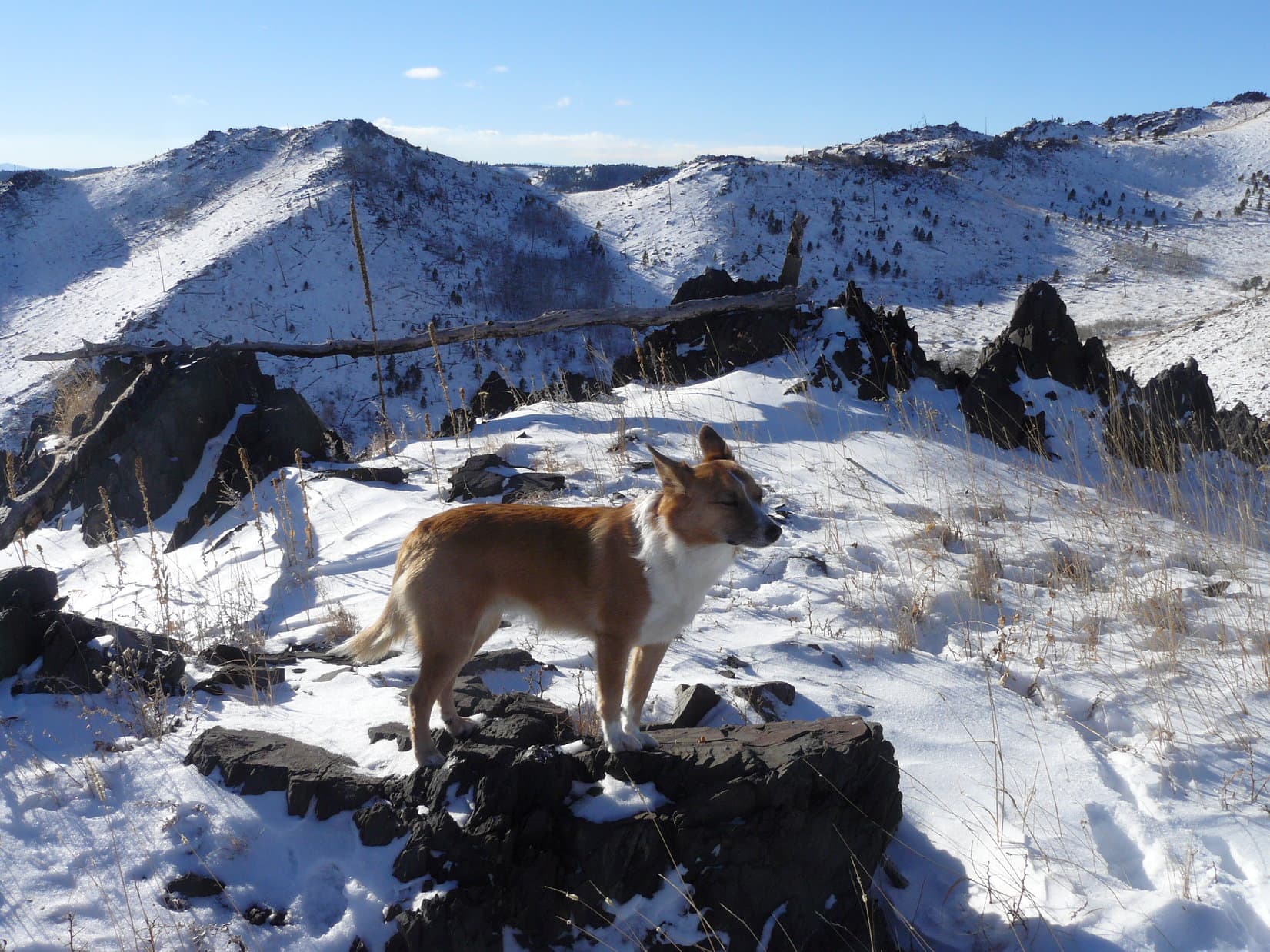
After consulting SPHP’s new topo maps, it was decided to check out part of the Beartooth Loop National Recreational Trail.  There was a trailhead just a few miles E along Hwy 212 near Long Lake.  Soon Lupe, Lanis and SPHP were setting out on the trail.  Lupe was very happy!  There was a lot of open ground with sweeping vistas where she could run and run.  She was full of energy!

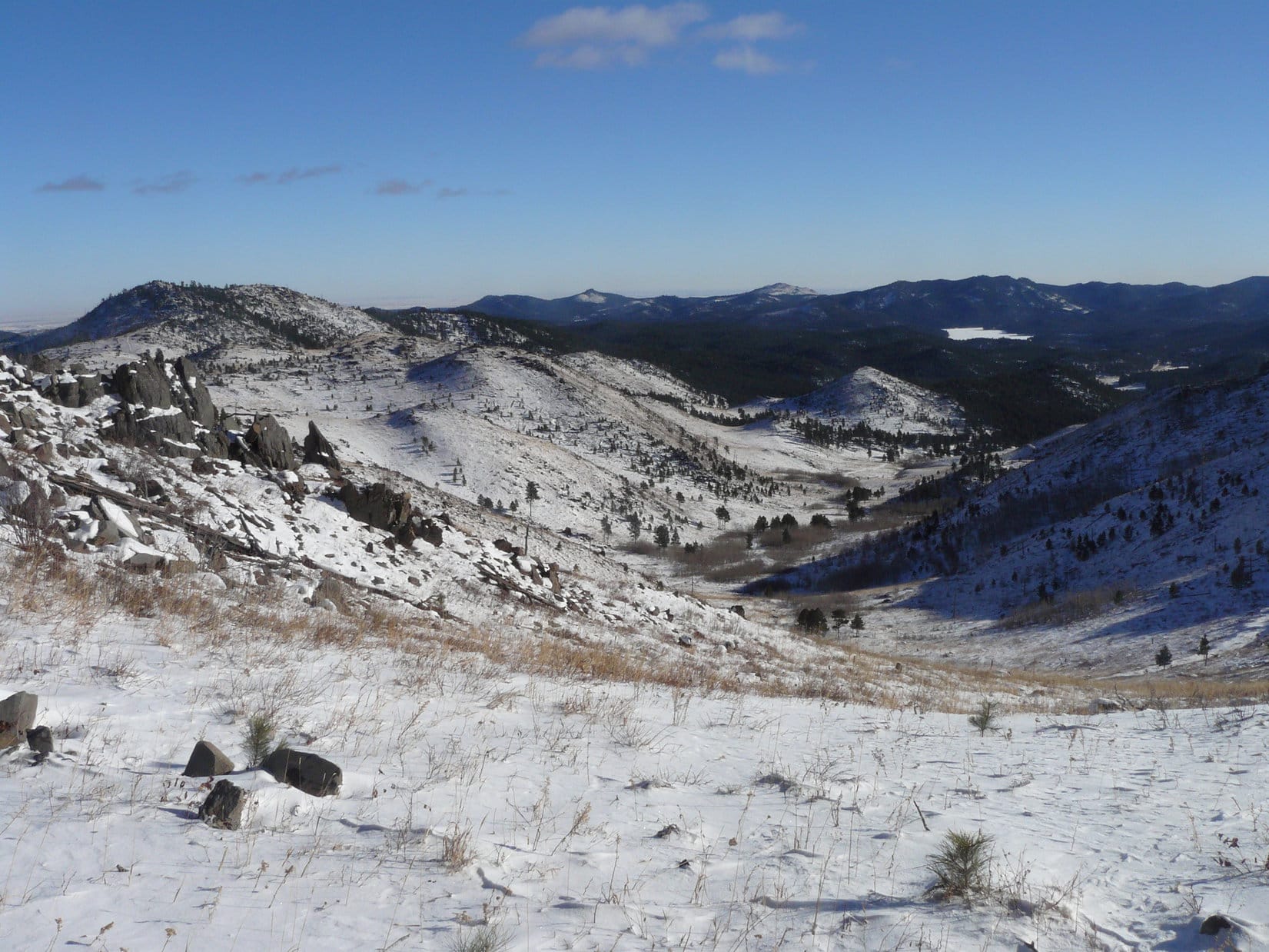
The trail went past several lakes.  Hauser Lake came first.  Quite a bit farther on, down in a valley, Lupe reached Losekamp Lake.  From Losekamp Lake, Lupe followed a spur trail that wound E up onto a ridge N of Tibbs Butte.  Up on the ridge, Lupe, Lanis and SPHP turned N to reach Gardner Lake – Lupe’s ultimate destination.

Open ground along the Beartooth Loop National Recreational Trail. Lupe ran all day!
Gardner Lake in the Beartooths. Photo looks N along the W shore.
Mountains NW of Gardner Lake.

The trek to Gardner Lake wasn’t as spectacularly beautiful as Lupe’s trip to Beauty and Becker Lakes a few days earlier.  There weren’t as many lakes and streams, the mountains didn’t seem quite as close or high, the forests were sparser and more distant, and there weren’t as many wildflowers.

On the other hand, there was much more open grassland where Lupe could race along with her nose to the ground sniffing at top speed.  At some points, there were some pretty grand sweeping vistas.  Best of all, there was absolutely no one else around.  And at Gardner Lake, Lanis did manage to find some pretty nice wildflowers near the shore.Wildflowers near Gardner Lake, Beartooths, WY 8-14-12Wildflowers near Gardner Lake, Beartooths, WY 8-14-12

Wildflowers at Gardner Lake.

Except for a long exploration of the forested ridge NE of Losekamp Lake, where Lanis and SPHP split up for a while, Lupe’s return trip from Gardner Lake just retraced her path from earlier in the day.  By the time Lupe was back at the Honda Element again, there was no question that she’d gotten enough exercise.  She had run all day long.  It had been a wonderful day to be a Carolina Dog wild and free in the Beartooths!

Lupe and Lanis near a pond just downstream of Gardner Lake. Tibbs Butte is seen in the distance. Photo looks S.

Lupe, Lanis and SPHP returned to the campsite on the Clark’s Fork of the Yellowstone River for another night in Lupe’s tiny house.  During her last evening on the beautiful river, the American Dingo slept very soundly.

The next morning, it was time to leave the Beartooths and start heading farther W.  After breakfast, Lanis and SPHP broke camp and packed up Lupe’s tiny house.  When everything was ready, Lupe jumped up into the Honda Element ready for whatever adventure might be next.

Lanis drove the Element E on Beartooth Hwy No. 212 again, just like the day before.  This time, Lupe was going to go over 10,947 foot Beartooth Pass, the highest point she had ever been to yet!  She was then going to cross the border into Montana for the very first time, making Montana the 3rd Lupe state!

Just a few miles before reaching Beartooth Pass, Hwy 212 was up on top of barren mountains overlooking Gardner Lake, where Lupe had been just the day before.  Naturally, Lupe, Lanis and SPHP wanted to stop and take a look at Gardner Lake from above.

From the Beartooth Hwy overlook, Lupe surveys Gardner Lake, where she'd had such a good time running around the day before. Tibbs Butte is seen on the L.
From the Beartooth Hwy overlook, Lupe surveys Gardner Lake, where she’d had such a good time running around the day before. Tibbs Butte is seen on the L.

Gardner Lake from Hwy 212, Beartooths, WY 8-15-12

Lanis and Gardner Lake.

Fog started sweeping over the ridge ahead as Lupe neared Beartooth Pass.  Up at the pass, the tops of the mountains were mostly clear, but the giant valleys and canyons to the N were full of clouds.  Lupe, Lanis and SPHP stopped for 20 or 30 minutes to look around, but it didn’t take long to get the idea what a bank of fog looked like.  Soon Lupe was on her way again.

Fog starts sweeping across the highway in places as Lupe approaches Beartooth Pass.
Above the clouds at Beartooth Pass.
The mountains had trapped a big bank of clouds N of Beartooth Pass. Photo looks NW.
The mountains had trapped a big bank of clouds N of the pass. Photo looks NW.

The border with Montana was just a few miles from Beartooth Pass, where the highway was still at a great height in the mountains.  Amazingly, there was a speed limit 70 mph sign up there!

Lanis especially found this highly amusing.  It was obviously some kind of Darwinian Introduction to Montana/Wyoming Intelligence Test (DIMWIT) to see if tourists were smart enough to survive in Montana.  For what lay ahead was not a nice straight, smooth highway, but miles of 20 mph, 15 mph, and even 10 mph hairpin curves snaking tortuously along the brink of tremendous precipices.

Partway down the giant descent, there was a little parking lot at a viewpoint.  Lupe, Lanis and SPHP stopped to check it out.

The first thing Lupe discovered at the viewpoint, was that squirrels were using little holes built into the bottom of the rock retaining walls to come onto the walkways and beg for food from tourists. Lupe was keenly interested in the frequent sudden appearance, and subsequent disappearance of all these squirrels! She peered over the walls to see where all these squirrels were disappearing to.
Lanis at the viewpoint N of Beartooth Pass in Montana. Clearly not having as much fun as Lupe! Perhaps suffering from coffee deprivation?

Montana along the Beartooth Hwy, 8-15-12View along Beartooth Hwy, MT 8-15-12View along Beartooth Hwy, MT 8-15-12

Lupe thought this viewpoint along the Beartooth Hwy, was great fun! She wanted to stay and play Catch-A-Squirrel (the American Dingo version of Whack-A-Mole) all day!

With all the clouds trapped on the N side of the Beartooth Mountains, it wasn’t surprising that it was raining by the time Lupe reached Red Lodge, Montana.  Lupe spent the afternoon snoozing comfortably in the Element while Lanis drove on to Bozeman.

In Bozeman, for the 1st time on her big 2012 Dingo Vacation, Lupe got to stay in the lap of luxury at a motel near I-90.  She was very curious about it all, but was on her very best behavior.  Dingoes are very adaptable to a wide range of conditions.  Rest assured, Lupe took a dose of soft living completely in stride!

Lupe leaves the driving to Lanis on the way to Bozeman, MT.

Links:

Next Adventure                       Prior Adventure

Want more Lupe adventures?  Choose from Lupe’s 2012 West Coast Adventure IndexDingo Vacations Adventure Index or Master Adventure Index.  Or subscribe free to new Lupe adventures.

Black Hills, SD Expedition No. 112 – New Year’s Eve Peak (12-31-14)

Two years ago, on Black Hills, SD Expedition No. 41, Lupe and SPHP had climbed Peak 6046 for the first time on the last day of 2012.  Back then, SPHP had given the private name “New Year’s Eve Peak” to the mountain.  At the time, it had seemed like it might be fun to make a little tradition out of returning to New Year’s Eve Peak on the last day of each year.  Of course, outdoor traditions at the end of December would always be subject to the weather, but that was just going to have to be a given.  Some years, Lupe wouldn’t make it back.

Sure enough, Lupe didn’t make it back on the last day of 2013, but weather wasn’t the culprit.  On December 30th, Lupe’s “grandma” suffered a transient ischemic attack (mini-stroke), and wound up in the hospital.

Now it was the morning of December 31st, 2014.  The morning was bright and frosty, very frosty – it had gotten down to -10°F overnight, way too cold for one of Lupe’s Black Hills, SD Expeditions.  Maybe Lupe was going to have to skip New Year’s Eve Peak in 2014, too?  The forecast held out some hope, though – it was supposed to get up into the low 30’s °F.

The forecast was accurate!  Things started warming up rapidly.  When it reached 30°F a bit before noon, it was time for Lupe to head out!  At 12:22 PM (30°F), SPHP parked the G6 on USFS Road No. 710 just off Hwy 385, about 3.5 miles S of the Pactola Reservoir dam.  Lupe was happy to be out in the hills again!  Lupe and SPHP started off following USFS Road No. 710 going W.

The road gradually climbed up through a small forested valley.  After more than half a mile, No. 710 started turning S, as it emerged from the valley onto more level, open ground.  Soon No. 710 turned SE, so Lupe and SPHP left it going SW instead.  Lupe was now out in an area that had burned years ago in a forest fire.  Just to the S, there was a low hilly ridge with rock outcroppings.  Lupe headed for it, and was rewarded with panoramic views of the snowy landscape.

Lupe reaches a high spot along the low, open hilly ridge. There were some pretty nice panoramic views from this area which had burned in a forest fire years ago. Photo looks W.
Looking SE now at Peak 5800 (L) from the low hilly ridge. It was kind of chilly up here in the WNW breeze.

Lupe followed the ridge heading WNW to stay up on the high ground, continuing to climb as she went.  She skirted along to the S of High Point 5917, then angled W to go down into a saddle between High Point 5917 and the next ridge.  It turned out there were two saddles, the first one being larger and deeper than the second one.

Another view back to the SE from farther WNW.

Instead of climbing up to the next ridge (Pistol Point), at the bottom of the second, smaller saddle, Lupe and SPHP turned NW heading directly for New Year’s Eve Peak, which was now only 0.33 mile away.  This route took Lupe into a rather snowy forest, with at least 6″ of snow on the ground compared to only 3″ or 4″ back out on the open ground.

The deeper snow didn’t seem to bother Lupe at all.  She lost some elevation as she went NW, but eventually reached a road.  The road was snowy too, but headed WNW up toward New Year’s Eve Peak.  A short distance S of the summit, the road curved around to the ENE.  Lupe and SPHP left the road to climb directly up the S slope of New Year’s Eve Peak.

Looking SW from the snowy SE slope of New Year's Eve Peak not far from the summit. A narrow gap in the forest provides a glimpse of distant blue mountains.
Looking SW from the snowy SE slope of New Year’s Eve Peak not far from the summit. A narrow gap in the forest provides a glimpse of distant blue mountains.

As Lupe neared the summit, she circled around a bit to make the final approach from the ESE.  It was an easy climb.  Before long, Lupe was perched up on the very highest rocks on top of New Year’s Eve Peak.  Two years after first climbing the mountain, Lupe was back to say good-bye to yet another year!

Lupe at the summit of New Year's Eve Peak on the last day of 2014. Photo looks W.
Lupe at the summit of New Year’s Eve Peak on the last day of 2014. Photo looks W.
Lupe at the summit of New Year's Eve Peak. A small cairn is visible next to her. Photo looks NE.
Lupe at the summit of New Year’s Eve Peak. A small cairn is visible next to her. Photo looks NE.

After a couple of photos of Lupe at the summit, Lupe and SPHP took a little break.  SPHP shared a chocolate-covered granola bar with Lupe.  Lupe made it clear she would be perfectly happy to complete the entire task of consuming it all on her own, but SPHP didn’t need quite THAT much help.

The summit of New Year’s Eve Peak was fairly heavily forested, so there wasn’t much of a view in most directions.  There were a couple of small openings in the forest, though, that provided a look off into the distance.  The best view was toward a succession of snowy blue hills off to the W.  Lupe and SPHP found a spot to sit down, huddled together against the cool breeze, to admire the view for a little while.

On the final afternoon of 2014, Lupe and SPHP sat together for a little while admiring this view of snowy blue mountains to the W from New Year's Eve Peak.
On the final afternoon of 2014, Lupe and SPHP sat together for a little while admiring this view of snowy blue mountains to the W from New Year’s Eve Peak.

Lupe had a great 2014.  This was her 39th Black Hills, SD Expedition of the year, in June she’d been on a luxurious Dingo Vacation to the Kabekona Lake cabin in Minnesota, she’d had a wonderful Summer of 2015 Dingo Vacation to the Canadian Rockies and Beartooths, and she’d climbed Lonesome Mountain (11,399 ft.) in the Beartooths, the highest mountain she had ever been on.  Now, on a chilly, quiet afternoon, way up on shady, lonely New Year’s Eve Peak, 2014 was slipping away forever.

It was actually a pretty good way to end the year, but didn’t change the sad fact that 2014 was passing into history.  Lupe and SPHP would have liked to stay up on New Year’s Eve Peak until sunset, but sunset was still a couple of hours away.  It was chilly enough up at the summit now, and wouldn’t be any warmer by then.

When Lupe and SPHP finally started back down off New Year’s Eve Peak, Lupe took the same route back to the G6, with one exception.  Down in the forested draw just SSE of the summit, Lupe took a side road that went S out to a high rocky spot.  From this high rocky spot, there were some great open views from the NE around to the S and W.  SPHP later named the spot Pistol Point, for a large rock that looked like a pistol handle sticking up out of the ground.

Lupe on her way back to the G6 from New Year's Eve Peak. Here she is at Pistol Point. Photo looks ESE toward Peak 5800.
Lupe on her way back to the G6 from New Year’s Eve Peak. Here she is at Pistol Point. Photo looks ESE toward Peak 5800.
Looking NE at New Year's Eve Peak from Pistol Point.
Looking NE at New Year’s Eve Peak from Pistol Point.
The wavy ridge just L of center is Five Points (6,221 ft.). The high spot just to the R is privately named False North Point (6,130 ft.). Photo looks S from Pistol Point.
The wavy ridge just L of center is Five Points (6,221 ft.)  . The high spot just to the R is privately named False North Point (6,130 ft.). Photo looks S from Pistol Point.
Lupe sniffs around at Pistol Point. The "Pistol" is the oddly shaped rock at center, which to SPHP somewhat resembles the handle of a pistol thrust into the ground.
Lupe sniffs around at Pistol Point. The “Pistol” is the oddly shaped rock at center, which to SPHP somewhat resembles the handle of a pistol thrust into the ground.

It was 3:52 PM (24°F) by the time Lupe and SPHP made it back to the G6.  Lupe’s final Black Hills, SD Expedition of 2014 was over.  SPHP was glad that Lupe had made a trip to New Year’s Eve Peak a real tradition by returning to the mountain.

Back at home, 2014 stole away in the night.  2015 found SPHP snoozing with a tired, warm American Dingo.  Peacefully and comfortably, another big year for Lupe was just beginning.

The last long shadows of 2014 lengthen on USFS Road No. 710 near the end of the day. The only tracks in the snow were Lupe's and SPHP's.
The last long shadows of 2014 lengthen on USFS Road No. 710 near the end of the day. The only tracks in the snow were Lupe’s and SPHP’s.

Links:

Next Black Hills Expedition                Prior Black Hills Expedition

Expedition No. 80 – New Year’s Eve Peak (3-23-14)

Expedition No. 150 – New Year’s Eve Peak & Peak 5800 (1-1-16)

Want more Lupe adventures?  Choose from Lupe’s Black Hills Expeditions Adventure Index or Master Adventure Index.  Or subscribe free to new Lupe adventures.