Black Hills, SD Expedition No. 217 – Peak 4400, Peak 4240 & Lookout Peak (11-26-17)

That Brian Kalet!  He does get around.  Lupe’s 2017 had started off with visits to a number of southern Black Hills peaks Brian had added to the Peakbagger.com data base in the spring of 2016.  SPHP hadn’t noticed until months later that about the same time Lupe was climbing in the southern hills, Brian had been visiting even more peaks along the NE edge of the Black Hills and adding them to the database, too.

So Lupe’s 2017 was going to end more or less the way it began, on the cold trail of Brian Kalet’s footsteps.

Loop had already been to one of the NE Brian Kalet peaks when she visited Peak 3950 near Sturgis a couple of weeks ago on Expedition No. 215.  Today she would tackle two more near Whitewood.  SPHP parked the G6 at Whitewood City Park (9:18 AM, 47°F).

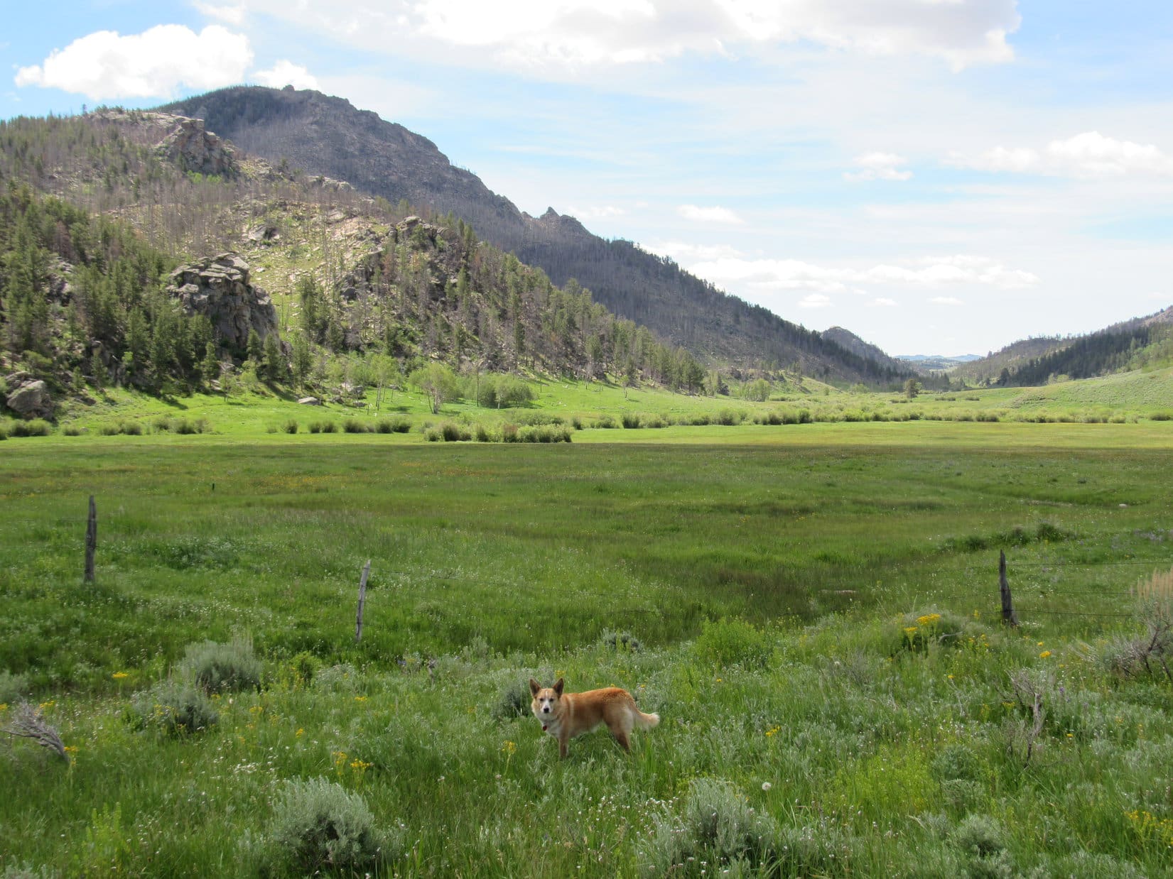
Looper set off in search of Peak 4400 about 1.5 miles to the SW.  She crossed a ravine, then started up a forested hill.  She soon came to a dirt road, and followed it higher to a better one.

Loop on the first road she came to early on her journey to Peak 4400. Photo looks S.
Higher up near the better road. Photo looks SW.

The better road took Lupe SW up to a level area where there was a big meadow.  Loop was close to High Point 4238 on the topo map.  Everything was going fine until Lupe heard gunfire.  Hunters?  The gunfire originated from somewhere off to the W, but sounded quite far off.

Lupe hates gunfire or explosions of any sort no matter how faint or far away.  She was instantly a nervous wreck and wanted to forget all about Peak 4400.  When the gunfire continued sporadically every few minutes, SPHP was certain it wasn’t from hunters.  Someone must be doing some target practice.  SPHP persuaded Lupe to continue, though she had lost all her enthusiasm.  She slunk along, staying close to SPHP.

A maze of minor dirt roads went through the forest.  Eventually, SPHP figured Lupe must be getting close to Peak 4400, and stopped to consult the topo map.  Suddenly a man appeared, walking straight toward Lupe through the woods.

The man hailed SPHP.  It turned out he was an employee of a company that leases 2,500 acres in this area.  He said this was all private property, not national forest land.  He was out with his young son checking cameras set up to monitor wildlife.  Lupe was right next to one.  The gunfire was indeed coming from a shooting range not terribly far NW of here.

The man was friendly, but insisted on taking Lupe and SPHP in his ATV winding N through the forest to a road that led out of the leased acreage down a valley to the E.  He and his son then roared away in the ATV.

Well, shucks.  Lupe started down the road to the E.  She hadn’t made it to the top of Peak 4400.  She hadn’t been too far SE of it either, from what SPHP had been seeing on the topo map.  Now she was 0.5 mile N of it.  Decisions.  Maybe it wasn’t the thing to do, but Loopster was already here.  This was the one and only time she would ever be, given the situation.  Lupe and SPHP left the road, heading S through the forest.

It didn’t take long for the American Dingo to reach a hilltop that looked like it might be the summit of Peak 4400.  This was just a high spot in the forest devoid of views, but Lupe posed on a tree stump for a couple of photos anyway.

Loop reaches a high point SPHP initially thought might be the summit of Peak 4400. Photo looks S.
Is this it? Can we go yet?

Lupe had scarcely left the hilltop when she caught a glimpse of Bear Butte (4,433 ft.) through a small opening in the trees.

Lupe had scarcely left the high point, when she caught a glimpse of Bear Butte through a small opening between the trees. Photo looks E.

The topo map showed quite a large area inside the 4,400 foot contour on Peak 4400.  In fact, there were two such areas 0.25 mile apart.  Lupe was in the N one now, which was where Brian Kalet had placed the true summit without further comment.

Maybe Lupe should look around here a bit more, just to make sure she’d reached the actual high point in the N contour?  She could then go check out the terrain in the S contour.  It wouldn’t take long.

A short search of the N contour area did show a higher point than where Lupe had been on the tree stump.  The true summit was actually a little farther SW, near the W edge of the mountain.

At the true summit of the N 4,400 foot contour. Photo looks SW.
Still at Peak 4400’s N summit, but now looking SSE.
Lupe was happy at the true summit of the N 4,400 foot contour. SPHP hadn’t told her about the S contour yet.

Satisfied that she’d reached the true summit of Peak 4400, because SPHP congratulated her and told her so, Loop was surprised to learn that she still had to visit a S 4,400 foot contour before she would be completely done with Peak 4400.  However, she was glad to head off in that direction, because it meant getting farther away from the sporadic gunfire still heard coming from the shooting range.

Off Lupe went, heading SE.  She reached the saddle leading to the S 4,400 foot contour, and crossed it.  Soon she was at the S edge of the mountain, where the terrain dropped away rather sharply.  Peak 4400’s S summit was nearby, close to a fence on a section line.

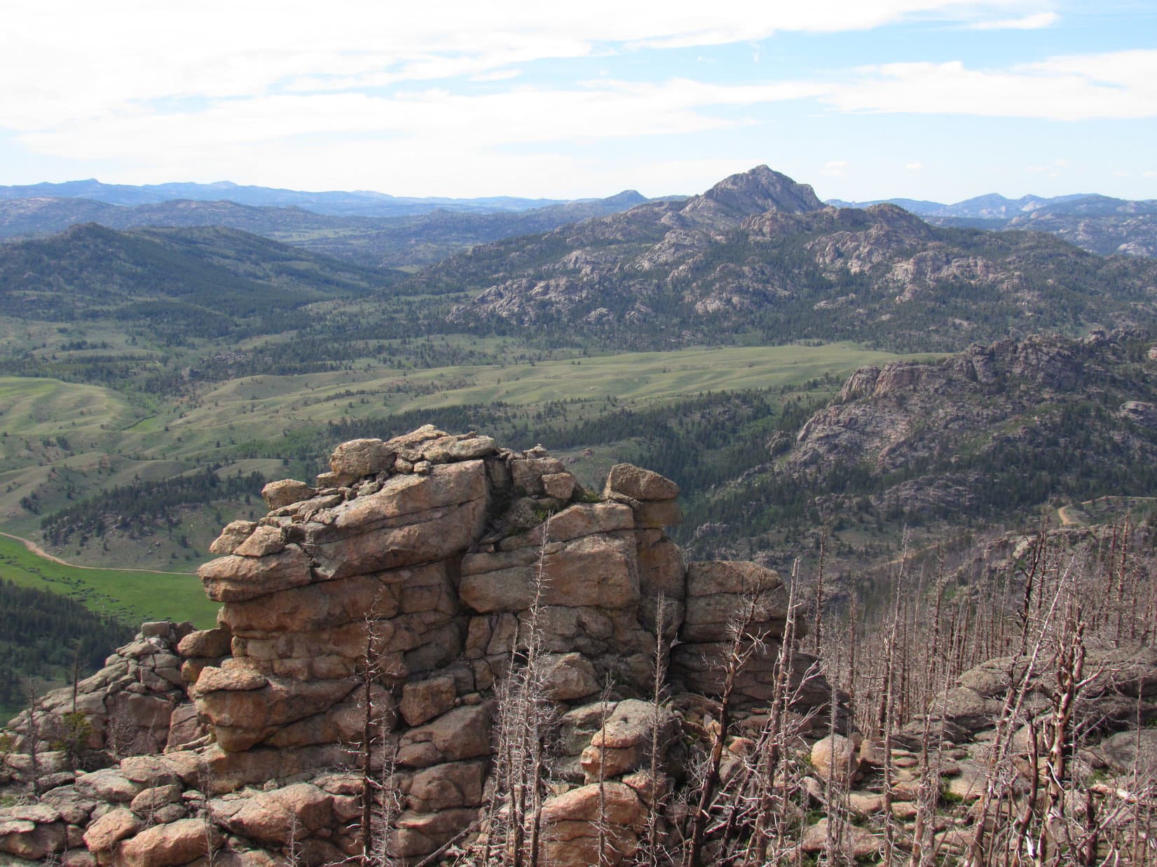
The S summit didn’t have much of a view, but shortly before reaching it Lupe had gotten a good look at Crook Mountain (4,930 ft.), and her next objective, Peak 4240.

After visiting Peak 4400’s N summit, Lupe headed SE looking for the S one. Here she’s approaching the saddle between them. Photo looks SE.
Nearing Peak 4400’s S summit, Lupe had this good look at both Crook Mountain, the high forested ridge in the background, and Peak 4240, the mostly barren lower ridge in the foreground. Peak 4240 would be her next objective. Photo looks SE.
At Peak 4400’s S summit. Terry Peak (7,064 ft.) is seen way off on the horizon in the narrow opening between the trees. Photo looks SW.

Well, Lupe had done it.  She had been to the true summit of Peak 4400.  Whether the N or S summit had been highest was uncertain.  Due to the forest, they couldn’t be seen from one another.  Brian Kalet had picked the N summit as the highest.  Both Loop and SPHP were happy enough to go along with that choice, right or wrong.

In any case, Lupe had been to both the N and S summits.  Better skedaddle, and leave Peak 4400 once and for all!  Going clear back to the road to the N that the nice man had shown SPHP as being the best route out of here would have been the long way around now.  Instead, Loop returned to Whitewood on a route pretty similar to the way she’d come up.

Lupe’s journey back to Whitewood from Peak 4400 was pleasant and uneventful. She seldom had any views, but did catch this one of Bear Butte. Photo looks E.

Once back at the G6 (12:33 PM, 65°F), Lupe and SPHP left Whitewood driving SW on Crook City Road.  SPHP parked the G6 again near the start of Oakbrook Road (12:45 PM).  Lupe’s next peakbagging goal, the summit of Peak 4240, was scarcely 0.25 mile SE of here.  Loop and SPHP took a stroll down Oakbrook Road looking for a way up.

At the W end of Peak 4240, an ATV trail left Oakbrook Road heading E up the narrow ridge straight for the summit.  Perfect!

The ATV trail started out in pine forest climbing steadily.  Soon Lupe came to a line of small S facing cliffs.  The ATV trail stayed a little N of them.  The cliff tops provided progressively better views, as the Carolina Dog journeyed up the hill.

Looper near the W end of Peak 4240 at the start of the line of small S facing cliffs. Photo looks ESE.

The short climb didn’t take Lupe long.  Soon she was at the top of the mountain.  As she’d seen from Peak 4400, the top of Peak 4240 was mostly bare.  The forest didn’t extend quite all the way to the summit.  Even though Peak 4240 wasn’t as high as nearby surrounding hills, the views were pretty decent.

Lupe arrives at the summit of Peak 4240 after a short trek up from the W. Heavily forested Crook Mountain (4,930 ft.) is in view. Photo looks SE.
Still at the summit. Whitewood Peak (5,140 ft.) is in view on the R.  Photo looks SW.
Bear Butte (4,433 ft.) (R) peeks over a ridge. Photo looks ENE.
Lupe squints in the sunlight. Elkhorn Peak (4,524 ft.) is the bare hill on the horizon at Center. The SW face of Peak 4400, where Lupe had just come from, is the high ridge on the R.
A little W of Peak 4240’s actual summit was this view of Pillar Peak (5,469 ft.) (L of Center). Photo looks S.
Pillar Peak (R) from Peak 4240 with help from the telephoto lens. Pillar Peak is sort of a special place to Lupe. Her very first blog post was about her Expedition No. 120 ascent of Pillar Peak on 2-20-15. Photo looks S.

It was fun to see so many mountains Lupe had been to before from Peak 4240!  She lingered, admiring the views.  Loopster couldn’t stay too long, though, if she wanted to climb another mountain today.  After a Taste of the Wild snack, the Carolina Dog was ready to move on.

Loopster near the cliffs, shortly before starting down Peak 4240. Whitewood Peak is on the far L. Photo looks WSW.

The last mountain Lupe would be climbing today wasn’t a Brian Kalet peak.  Lookout Peak (4,478 ft.) had been added to the Peakbagger.com data base a long time ago by Doug Melton, another prolific peakbagger.  Lookout Peak is the dominant mountain E of I-90 at Spearfish, SD.  When Lupe got back to the G6 (1:29 PM), SPHP drove her to Spearfish.

Late November, yet it was an amazing 72°F when SPHP parked the G6 at a little park at the S end of Saddle Horn Drive (1:57 PM).  Lupe hopped out.  Very few of her mountain ascents had ever started in a town, but this one was going to.  Lupe and SPHP strolled 0.5 block N on Saddle Horn Drive, before turning W on Branding Iron Drive.

SPHP had no idea what the situation was on access to Lookout Peak, but on the way in from the SE had seen a road zigzagging up the mountain’s S slope above a residential subdivision.  There were towers on Lookout Peak, so there must be a way up somewhere.  Loop wasn’t far from that zigzagging road now.  Would it really be as easy as simply sauntering through the neighborhood to get to it?

Branding Iron Drive curved SW.  Loop took a R on Pony Express Lane.  Ahead, at the upper end of this short street, a dirt road curved L out of sight.  Most promising!  When Lupe got to the end of the street, a sign showed that this was the access road to Lookout Mountain Park.  The sign listed a few simple rules, none prohibiting Dingoes.

And it was as easy as that!  Lupe trotted up Lookout Peak’s S slope on the zigzagging road.  The road brought Loop to a forested high point ESE of the summit.  From there, it continued across a saddle to the base of the summit knob.

Approaching Lookout Peak’s summit knob. This access road starts at the end of Pony Express Drive in Spearfish. Photo looks W.
Crow Peak (5,787 ft.) (far L), the dominant mountain W of Spearfish, is on the horizon. Photo looks WSW.

At the base of the summit knob, a trail left the road going right on up to the top.  The trail was rocky and a bit scrambly, but short.  In minutes, Lupe was approaching the towers at Lookout Peak’s summit.

Approaching the summit. Photo looks W.
These towers and little buildings are right at Lookout Peak’s true summit, near the E end of the summit knob.

The area right around the true summit was crowded with towers and buildings.  Approaching from the E, the summit had appeared like a big knob, but once Lupe was on top, she could see it was more elongated and ridge-like toward the W.  The terrain sloped down in that direction, yet looked like it might be the best place to check out the views.

Lupe trotted W past the true summit to see what she would find.

Lupe WNW of the true summit on Lookout Peak. Crow Peak is in view beyond the city of Spearfish. Photo looks WSW.
Peak 4433, the high ridge in the distance, is another Brian Kalet peak of interest to Lupe. She wasn’t going to get there today, though. Photo looks NE.
The city of Belle Fourche is barely visible beyond the distant low pine-covered hills on the L. Photo looks N.
Looking up the path to the true summit from the lower W portion of the summit ridge. Lupe may not have been quite as high here, but this area was prettier without all the towers and buildings around. Photo looks SE.

Lupe came to exposed ledges of large flat rocks at the far WNW end of the summit ridge.  Although at the low point of the entire summit area, the ledges provided some of the finest views from Lookout Peak.

From this exposed rock ledge at the far WNW end of the summit ridge, Lupe had some of the best views available from Lookout Peak. Crow Peak (L) and a good portion of downtown Spearfish are in view. Photo looks W.
Looking NW.

On the way back to the G6, Lupe stopped by the true summit for a photo.  Then it was all downhill from here.  Some of the views on the way down were really nice, too.

Lupe at the true summit.
Starting down the short scrambly trail to the access road. The mouth of famed Spearfish Canyon is in view beyond I-90 toward the R. Photo looks SSW.
View to the SSW from Lookout Peak. Spearfish Peak (5,800 ft.) is at Center. Similarly shaped, but more distant Little Crow Peak (5,885 ft.) is toward the R. The mouth of Spearfish Canyon is on the far R.

While Loop had been up at the summit, she’d had the whole mountain to herself.  Apparently, this was just a lucky fluke, at least on a gorgeous day like today.  On the way down, she started meeting lots of people and dogs coming up.  Lupe enjoyed all the sniffing that went on.  She wagged her curly tail at the little dogs, and growled at the big ones.

Whitewood Peak (5,140 ft.) is the high point on the far horizon on the L. Closer by at Center is Green Mountain (5,325 ft.). Immediately to its R is Polo Peak (5,410 ft.).  The highest point even farther R is Mount Theodore Roosevelt (5,680 ft.).  Photo looks SE.

The sun was still up, when Lupe got back to the G6 (3:34 PM, 62°F).  Loop and SPHP spent the remaining hour of daylight driving around scoping out Peak 4433, another Brian Kalet peak of interest in the area.  Perhaps someday Lupe will return to climb it, too.  But that will be another Black Hills, SD Expedition and a different adventure.

Lookout Peak from the NE at the end of the day, 11-26-17.

Links:

Next Black Hills Expedition                      Prior Black Hills Expedition

Want more Lupe adventures?  Check out her Black Hills, SD & WY Expeditions Adventure Index, Master Adventure Index, or subscribe free to new Lupe adventures!

Jack Squirrel Peak, Laramie Range, Wyoming (6-19-17)

Day 12 of Lupe’s 2017 Dingo Vacation to the Laramie Range in Wyoming & Beyond!

Lupe could hardly believe her big soft Dingo ears!  Her spine tingled with excitement.  She stared at SPHP in wide-eyed wonder and disbelief.  Was it true?  Was she really on her way to fabled Squirrel Mountain?  Oh, joy!

Not Squirrel Mountain, Loop – Jack Squirrel Peak.

Mountain, peak, what difference did it make?  Loop didn’t know and didn’t care.  She was certain Squirrel Peak would be every bit as fabulous as Squirrel Mountain.  How could it not be?  In fact, the notion that there might be both a Squirrel Mountain and a Squirrel Peak was an exciting idea she’d never even thought of before.

I’m not even certain what a jack squirrel is, Looper.  Maybe a jack squirrel is just larger than ordinary squirrels with a super long bushy tail?  Kind of like a jack rabbit is bigger than ordinary rabbits and has longer ears and legs.

The American Dingo’s eyes grew even bigger.  This was too good to be true!

Oh, I hope you’re right, SPHP!  This is going to be the best mountain ever!  I never should have doubted you.  Your the best friend a Dingo ever had!  This is going to make up for when you forgot the whiskey on Whiskey Peak, and then some.

Well, maybe it would, and maybe it wouldn’t.  SPHP parked the G6 on the S side of County Road No. 710 where it turned W near Silver Tip Creek (10:43 AM, 62°F)Jack Squirrel Peak (8,942 ft.) was only 1.5 miles SSE from here at the S end of the long Eagle Mountain ridge.

Several log and wooden structures were on the other (N) side of County Road No. 710 from where SPHP parked the G6. They all seemed to be abandoned. Photo looks N.

Most of the territory E of here, including Jack Squirrel Peak, was all national forest land.  However, by far the easiest way to the mountain was to head S across a big field N of the confluence of Silver Tip and Bear Creeks.  Though this field was private property, signs on the fence said this land was open to the public for hunting.

We’re hunting jack squirrels, right Loop?

Of course!  We’ll be back soon with passels of ’em!  We’re entirely legit.

I’m not even sure if it’s jack squirrel season.  You’ll vouch for me if anyone objects?

Don’t be ridiculous, SPHP!  It’s always squirrel season, jack or not.  We Dingoes are experts on the subject.  Carry on!  Just point me to Squirrel Peak!

Loop ready to depart for Jack Squirrel Peak (L). Photo looks S.

As excited as she could be, Lupe crossed the big field sniffing madly trying to pick up a scent.  Nearing Silver Tip Creek, she found a dirt road that got her over to the E side of the creek.  Once across, Loop followed the road S beyond Silver Tip’s confluence with Bear Creek.

Lupe heading for the promised land of Jack Squirrel Peak! She’s E of Bear Creek here, and will go up the L side of the low hill directly ahead to enter Hidden Gulch. Photo looks S.

A low hill was up ahead.  Loop left the road to climb it.  Reaching the top, she had a view of Hidden Gulch.

Hidden Gulch from the top of the low hill. High Point 8608 looms above the upper end of Hidden Gulch on the R. Photo looks E.

Hidden Gulch was part of the planned ascent route up Jack Squirrel Peak.  Lupe left the low hill heading E.  She stayed N of a tributary of Bear Creek flowing down the valley.  The intention was for Loop to go all the way up Hidden Gulch to the main N/S ridgeline at a saddle just S of High Point 8608.  At the saddle she would turn SW and follow the ridgeline to the summit.

Things started out OK, but Lupe soon came to a thick forest down by the stream.  The valley was already increasingly rocky, full of boulders and deadfall timber.  The forest appeared impenetrable.  It looked far easier to avoid the forest entirely.  Lupe and SPHP crossed over to the S side of the stream, and began climbing.

The forest had burned on the S side of the valley.  The slope was fairly steep and quite rocky, but the rocks were good-sized and mostly stable.  It wasn’t hard scrambling up among them.

A forest fire had burned the slope on the S side of Hidden Gulch. Though the area was very rocky, the rocks were mostly stable and easy enough to scramble up. Photo looks SE.

The new plan was to keep proceeding ESE up Hidden Gulch as Lupe gained elevation.  She might not have to go all the way to the main ridgeline S of High Point 8608.  Maybe she could manage a more direct route up Jack Squirrel Peak from the N or NW.

The American Dingo climbed and climbed.  The mountain kept getting steeper.  Despite what the topo map showed, the easiest way up always seemed to be more toward the W slope.  Lupe was already quite high by the time SPHP realized how far around to the W she’d gotten.

Lupe was already pretty high up by the time SPHP realized how far she’d drifted around onto Jack Squirrel Peak’s W slope. Huge rocks were everywhere, and the mountain was getting steeper with no relief in sight. Photo looks NW.
On Jack Squirrel Peak’s W slope. The Bear Creek valley is seen on the R. Photo looks S.
Looper looking in vain up Jack Squirrel Peak’s W slope for signs of any jack squirrels. Photo looks E.

Lupe started coming to massive rock formations separated by wide chutes of loose rock and boulders.  She went around the first one or two staying toward the SW.  However, the SW side of the mountain was becoming more intense.  Lupe was finally forced to climb NE up a long chute full of boulders.  Near the top she reached less difficult terrain.

Passing around the SW end of one of the massive rock formations, with another one directly ahead beyond a field of boulders. Photo looks ENE.
Near the upper end of the long chute, Lupe finally escapes the worst of the steep W slope. Photo looks NE.

Lupe was certainly getting up in the world!  Off to the NNE she now had a tremendous view of Eagle Peak (9,167 ft.) at the opposite end of the long Eagle Mountain ridge.  Only 10 days ago, Loop had nearly made it to the top of Eagle Peak, but had failed to find a route up onto a vertical rock wall at the top of the mountain.

Lupe was certainly getting up in the world! Off to the NNE she had a tremendous view of Eagle Peak.

Unfortunately, the American Dingo’s ability to get to the top of Jack Squirrel Peak was fast becoming a concern, too.  Although most of the terrain ahead was much easier than where Lupe had just been, a rock formation higher than anything else in sight sat perched high above the opposite side of the long chute she’d just come up.

Was that rock formation Jack Squirrel’s summit?  SPHP hoped not, but feared it might be.  The formation wasn’t all that large, but was at least 20 or 30 feet high.  The part of it in view from here had nearly vertical sides.  Unless the unseen side was a lot easier to climb, Lupe didn’t stand a chance of getting to the top.

On the opposite side of the long chute full of boulders Lupe had just come up, a knob of rock (L) sat perched higher than anything else around. Was that the summit? Failure loomed, if it was. Lupe wouldn’t be able to get to the top of that thing! Photo looks ENE.

Loop and SPHP headed for the rock formation.  When Loop got there, it turned out that the knob of rock was actually more like a narrow ridge.  It was long and skinny, not round.  The E side looked virtually the same as the W side Lupe had seen first.  Loop got up within 20 or 25 feet of the top, but that was as far as she could go.

When Lupe got there, the knob of rock turned out to be more like a narrow ridge. Lupe could get within 20 feet of the top, but no higher. Photo looks SW.

Fortunately, Looper didn’t need to get to the top of this rock formation.  It was only a false summit.  Beyond it, not too far away, was even higher ground.  The Carolina Dog could keep climbing!

Fortunately, the rock formation Lupe had reached was only a false summit. Higher ground was in view ahead. The Carolina Dog could keep climbing! Photo looks ENE.

The higher ground nearby was it!  Just like that, Lupe was at the summit of Jack Squirrel Peak (8,942 ft.).  It hadn’t been all that hard to get here after all.  The last part of the climb had been easy!

SPHP was ecstatic.  Loop seemed shocked by the news.  This was it?  The summit of Jack Squirrel Peak?  She got up on the highest rock for a photo as requested, but her heart didn’t seem to be in it.

Loopster at the top of Jack Squirrel Peak! Photo looks SSE.

The views were enormous, but the first to capture SPHP’s attention was an impressive wall of rock SSE of the summit.  It towered hundreds of feet above surrounding terrain, and looked virtually as high as the summit where Lupe stood.  In fact, parts of the wall appeared slightly higher.  Wasn’t Loop at the true summit of Jack Squirrel Peak?

The first view to capture SPHP’s attention was a towering wall of rock SSE of the summit where Lupe stood. It looked as high as where Lupe was, maybe even a little higher. Photo looks SSE.

SPHP checked the topo map.  Lupe was at the point where a site elevation of 8,942 ft. was shown within the larger of two 8,940 foot contours, the smaller contour being located along part of the rock wall to the SSE.  No site elevation was shown in that contour.

Well, Loop, I could convince myself there are parts of that gigantic rock wall that are higher than we are here, if I wanted to.  It kind of looks that way.  On the other hand, having terrain at some distance falsely appear higher is a pretty common optical illusion, too, as we’ve seen on other peaks.  The highest elevation shown on the topo map is right where you are now.

In any case, we’re claiming a peakbagging success for you!  If some purist wants to risk their neck to possibly gain 6″ or 2 feet more, or whatever it may actually be over on that rock wall, they are welcome to it.  It’s way too dangerous over there for us.  It may not be any higher anyway.  So this is it!  Good enough for Dingo work!  Congratulations, Looper on reaching the top of Jack Squirrel Peak!

SPHP shook Lupe’s freckled paw.  She smiled weakly, but said nothing.  She looked despondent.

Whether or not this giant rock wall was any higher than the 8,942 foot site elevation Lupe had reached was difficult to tell. In any case, it was way too dangerous for Lupe and SPHP to go over there. Loop was at the highest elevation actually indicated on the topo map. She was claiming a peakbagging success! Photo looks SSE.
Even after SPHP congratulated Loop on her Jack Squirrel Peak success, she looked a little down. The false summit Lupe had gone by on the way up is in view to the L of her head. The high peak in the distance seen straight up from her head is Windy Peak (9,080 ft.). Photo looks NW.
A closer look with help from the telephoto lens. The false summit Lupe went by is in the foreground on the L. Windy Peak is in the distance on the R. Photo looks NW.

Time for a break.  Lupe got down off the summit rock, and curled up near the backpack.  SPHP munched an apple, but Looper refused her Taste of the Wild.  She drank only a little water.

You OK, Loop?  What’s wrong?

Lupe stood up, gazed sadly at SPHP, then lowered her head.

Loop?

SPHP gave her a pat.

It’s terrible!  Simply awful, SPHP!  Just ….. sickening!

What is, Loop?

Lupe puked.  Three times.  It took her a moment to recover.

Jack Squirrel Peak!  Don’t you pay any attention, at all, SPHP?  Practically the whole mountain has burned.  The forest is ashes.  All the jack squirrels are dead and gone.  We haven’t seen a single one!  It’s horrible!  I thought we were coming to a squirrel paradise, but everything’s in ruins.  We’ve come all the way to the top, and it’s clear we aren’t ever going to see a jack squirrel.  My hopes are nothing but ashes now, too!

SPHP hugged Lupe, then sat with her stroking her soft fur.

Oh, Loop!  I’m sorry you feel so bad!  You’re right, the forest has all burned.  We haven’t seen any squirrels, jack or otherwise, at all.  It must be terribly disappointing to you.  You know what, though?  Since there weren’t any jack squirrels here, I’ll take you to some other mountains where there will be plenty of  squirrels.  They may not be jack squirrels, but you’ll still have fun!

Really?  I thought we were just going home after this.  Isn’t my Dingo Vacation almost over now?

Yes, we are going home after this.  Only for a little while, though.  Your Dingo Vacation to the Laramie Mountains is about done, but in July you’re going on another Dingo Vacation to even bigger mountains.  You’ll see lots of squirrels, and other animals, too!  Plus I’ll have a big surprise for you before it’s over!

Really?  Promise?

Promise!  You can count on it.  You’re going to be one busy, lucky Dingo this summer!  Say, you’re looking a little better.  Listen, now.  The forest and the jack squirrels may be gone, but Jack Squirrel Peak is still quite a mountain.  The views are stupendous here.  Let’s look around a bit, get some photos, then we can head down.  Whad’dya say?

OK, sure.  I do feel a little better.  Thanks, SPHP!

Lupe got up on several different high rocks for photos.  Then she curled up to rest a bit longer, while SPHP took a few more pictures.

Laramie Peak (10,272 ft.), the highest mountain in the Laramie Range from Jack Squirrel Peak. Photo looks NE.
Looking NNE at Eagle Peak. High Point 8608 is the massive block of rock seen straight up from Looper’s rump. Photo looks NNE.
Windy Peak is on the L. South Sawtooth Mountain (8,723 ft.) is the distant high point at Center. Photo looks NNW.
Eagle Peak and the long ridge leading to it from Jack Squirrel Mountain. Photo looks NNE with help from the telephoto lens.
Laramie Peak. Photo looks NE.
View to the SSW from the summit of Jack Squirrel Peak.
The Laramie Mountains, where Lupe had such a good time on her 1st Dingo Vacation of 2017. Photo looks WNW.

On the way back, Lupe took a much different route.  Instead of going down the W slope, she tried heading NNE to the saddle near High Point 8608, but it was tough going and Loop didn’t stay the course very long.  She ended up descending the N face of Jack Squirrel Peak.  It was steep with lots of rocks, deadfall timber, and some live trees as well.  For a while, SPHP was afraid the Carolina Dog might cliff out, but she didn’t.

It took a long time for Loop to work her way down to the upper reaches of Hidden Gulch.  The forest had all burned here, but the forest floor sported a grand profusion of green plants with showy yellow flowers.  Lupe was feeling better by now.

By the time Lupe made it down to the upper reaches of Hidden Gulch, she was feeling much better.
Exploring Hidden Gulch.

Lupe made her way to the tributary of Bear Creek.  Staying to the N, she followed it W down Hidden Gulch.  When Loop finally got out of Hidden Gulch, the rest was easy.  Soon she could see the G6 parked across the green meadow near County Road No. 710.  On the other side of the road, the old wooden barns and outbuildings sat quietly at the foot of Jaybird Peak.

This was it.  The final stroll of Lupe’s 2017 Dingo Vacation to the Laramie Range in Wyoming & Beyond lay before her.  She’d had a great time on this trip, and more Dingo Vacations and adventures would be coming soon, but they didn’t matter yet.  It was still June, and a gorgeous evening.

The Carolina Dog ran down to Silver Tip Creek for a drink of cold water, then trotted into the big green field.  Sniffing and exploring happily, she played a little longer in the evening’s glow before heading home (7:03 PM, 65°F).

Looking N toward Jaybird Peak, Laramie Mountains, Wyoming, 6-19-17

Related Links:

                Next Dingo Vacation                          Prior Adventure

This Dingo Vacation                                      Prior Dingo Vacation

Eagle Peak, Laramie Range, Wyoming (6-9-17)

Want more Lupe adventures?  Choose from Lupe’s 2017 Laramie Range, Wyoming & Beyond Adventure IndexDingo Vacations Adventure Index or Master Adventure Index.  Or subscribe free to new Lupe adventures.