Right on time, the guest of honor dashed into Grandma’s house wearing her party hat. Lupe has always celebrated her birthdays at Grandma’s, and wasn’t about to break with tradition. Good things always happen to her here, and there was no sense in taking any chances on her big day.
Let the festivities begin! The party animal has arrived! Lupe felt fully up to the task of being pampered.
Of course, Grandma was the first to greet Lupe and welcome her to her home.
The 7 year old birthday girl looks forward to being adored.Grandma welcomes birthday girl Lupe.
Most years the only guests at Lupe’s birthday party are Grandma, Grandma’s 3-legged cat Butterfly, and SPHP. This year was different. Mush was here, too!
Grandma, Mush and Lupe all together. Quite a crowd for a Lupe birthday, but Loop could handle the additional lovin’. American Dingoes are instinctive experts at both giving and receiving love.Mush and Loop. This was Mush’s first Lupe birthday experience ever.
In 2016, SPHP had baked Lupe a birthday cake for her 6th birthday. It had turned out pretty well, especially considering SPHP’s general level of culinary skills. This year, though, it was time for a step up. For the first time ever, Lupe had a store-bought birthday cake. It was decorated with colored sprinkles and pink, purple, and yellow balloons made of whipped cream icing.
Lupe’s first ever store bought birthday cake, complete with a clever message appropriate for the occasion.
No birthday party for a 7 year old girl is complete without presents! SPHP had brought 4 wrapped presents for Loop. What was inside? Lupe was dying to know, but she couldn’t open them quite yet.
Lupe with her birthday cake and presents from SPHP on either side of her. She was enjoying the moment, eagerly awaiting permission to dig in!
Next came the scary part about birthdays – all those dangerous flaming candles! Lupe tried to be calm, but it took all her bravery and a command to sit right there from SPHP to avoid fleeing the scorching bonfire her birthday cake had become.
Lupe was very brave and managed to sit next to 7 frightening flaming candles on her birthday cake long enough for Grandma, Mush & SPHP to sing “Happy Birthday” to her.Lupe’s scary 7th birthday cake.
Mush blew out Lupe’s birthday candles for her to end the terror. The only bad part was that Mush only blew 6 out on her first try. She used a 2nd breath to blow out the 7th candle. Did that mean Lupe’s birthday wish wouldn’t come true? The Carolina Dog certainly hoped that wouldn’t be the case, but what was done was done.
Anyway, now that the scary part was over, it was time for presents! Mush helped Lupe open them. The first present was an instant hit – a T-bone steak from SPHP.
Mush helped Lupe open her presents. The first one was a T-bone steak from SPHP.At least one wish Lupe had on her 7th birthday came true. She got a T-bone steak!
Next came a new Kong squeaker ball.
Lupe’s 2nd present was a new Kong squeaker ball. Loop loves squeaker balls!
The 3rd present turned out to be a bag of Purina Waggin’ Train Chicken Jerky Tenders. Even though Grandma was already broiling her T-bone steak for her, Lupe decided maybe she should have a chicken jerky tender as an appetizer. Not that there was a thing wrong with her appetite, you understand. The jerky tender vanished in nothing flat.
The Purina Waggin’ Train Chicken Jerky Tenders bag had a picture of a very happy dog that looked a lot like Lupe on it, so right away she knew they were going to be good.These chicken jerky tenders are yummy, but don’t stop now! Keep those presents coming!
Lupe’s 4th and final present from SPHP was a new Tuffy UltFlyer flying disc. It’s very strong and made of cloth, so it doesn’t hurt to catch it. The new flying disc was exactly like one Lupe had received from Erik & Ana a year ago in the PupJoy box they’d ordered for her. Loopster still has and uses her old flying disc practically every day, but it’s looking pretty frazzled by now. The squeaker inside hasn’t worked for months.
Lupe’s new Tuffy UltFlyer flying disc, still in the wrapper.
That was all the birthday loot Loop got from SPHP, but she wasn’t done yet. Grandma also had a present for Lupe, a big bag of Nudges Chicken Jerky Cuts. They also looked delicious!
Loop thought maybe she should sample one of the Nudges Chicken Jerky Cuts, too, just to keep her appetite up. SPHP said even though it was her birthday she shouldn’t open a 2nd bag of treats. She would have to save the Nudges until the 1st bag was gone so they would stay fresh. Besides, she’d already proven there wasn’t a thing wrong with her appetite.
Grandma gave Lupe a great present, too! A big bag of Nudges Chicken Jerky Cuts.
Lupe now had a little time for some Kong squeaker ball fun with Mush and SPHP while Grandma was busy broiling her T-bone steak for her.
Fun times with the new Kong squeaker ball while Lupe’s T-bone steak is getting broiled.
It wasn’t long before Grandma had the T-bone broiled to perfection. It was nice and hot, yet still a bit pink and bloody. The squeaker ball was a blast, but T-bone steak is Lupe’s favorite meal. She was able to tear herself away from the squeaker ball long enough to devour her scrumptious steak. SPHP cut the steak into bite-sized pieces for her.
Birthday dinner is served! T-bone steak is Lupe’s favorite meal.Cooked to perfection! Hot, yet still pink and a bit bloody. What more could a Dingo want?If you’re going to cut this steak up into pieces for me, you’d best get on with it SPHP! I’m perfectly capable of dealing with it all by myself, if you don’t.
The Purina Waggin’ Train Chicken Jerky Tender had done its job. Lupe’s appetite was great! In fact, she was famished! The entire T-bone steak disappeared as fast as SPHP could cut it up.
Everything disappeared except the actual T-bone, that is. SPHP made sure to leave some meat clinging to it. Lupe would get the bone later on at home.
Cake and ice cream was coming, but a little exercise was in order first. Lupe is a regular visitor at Grandma’s house. She always likes to go the cul-de-sac at the end of the street with SPHP at least once every time she’s here. This time of year, Loop enjoys the pretty Christmas lights while still keeping an eye out for bunnies and deer.
It was another warm evening for December. For the first time SPHP could remember, there wasn’t any snow on Lupe’s birthday.
Lupe stopped by the most beautiful Christmas tree near the end of the cul-de-sac. Every year this same tree is all decorated up with hundreds of colorful lights. Unfortunately SPHP’s photo is underexposed and too dark to do the tree justice.Loop by another pretty tree that came out better.
When Lupe got back from the cul-de-sac, she went to see Butterfly, Grandma’s 3-legged cat. Butterfly always used to be at Lupe’s birthday parties, but now she likes to stay upstairs all the time. Lupe at least wanted to say hello to Butterfly on her birthday.
Lupe went upstairs to see Butterfly for a few minutes. Butterfly seldom comes downstairs any more, but used to be a regular attendee at Lupe’s birthday parties.
After her visit with Butterfly, it was time for cake and ice cream. The cake was rainbow colors inside. Lupe mainly liked licking the whipped cream icing off the cake. She devoured all the cookies ‘n cream ice cream SPHP would give her.
Full of cake, ice cream and T-bone steak, Loop spent the rest of the evening snoozing peacefully on Grandma’s soft carpet until it was time to go home.
At home, SPHP presented Lupe with her T-bone with meat still clinging to it. Lupe gnawed and gnawed. The T-bone was a very satisfying way to end another great birthday.
Lupe’s 7th birthday party had been a big success! Now she’s going to be 7 for a whole year. Lupe has never been 7 years old before, and isn’t certain what the coming year will bring. 7 is supposed to be a very lucky number, though, so she’s looking forward to many more Dingo Adventures, and hopes you are, too!
Day 10 of Lupe’s 2017 Dingo Vacation to the Laramie Range & Beyond!
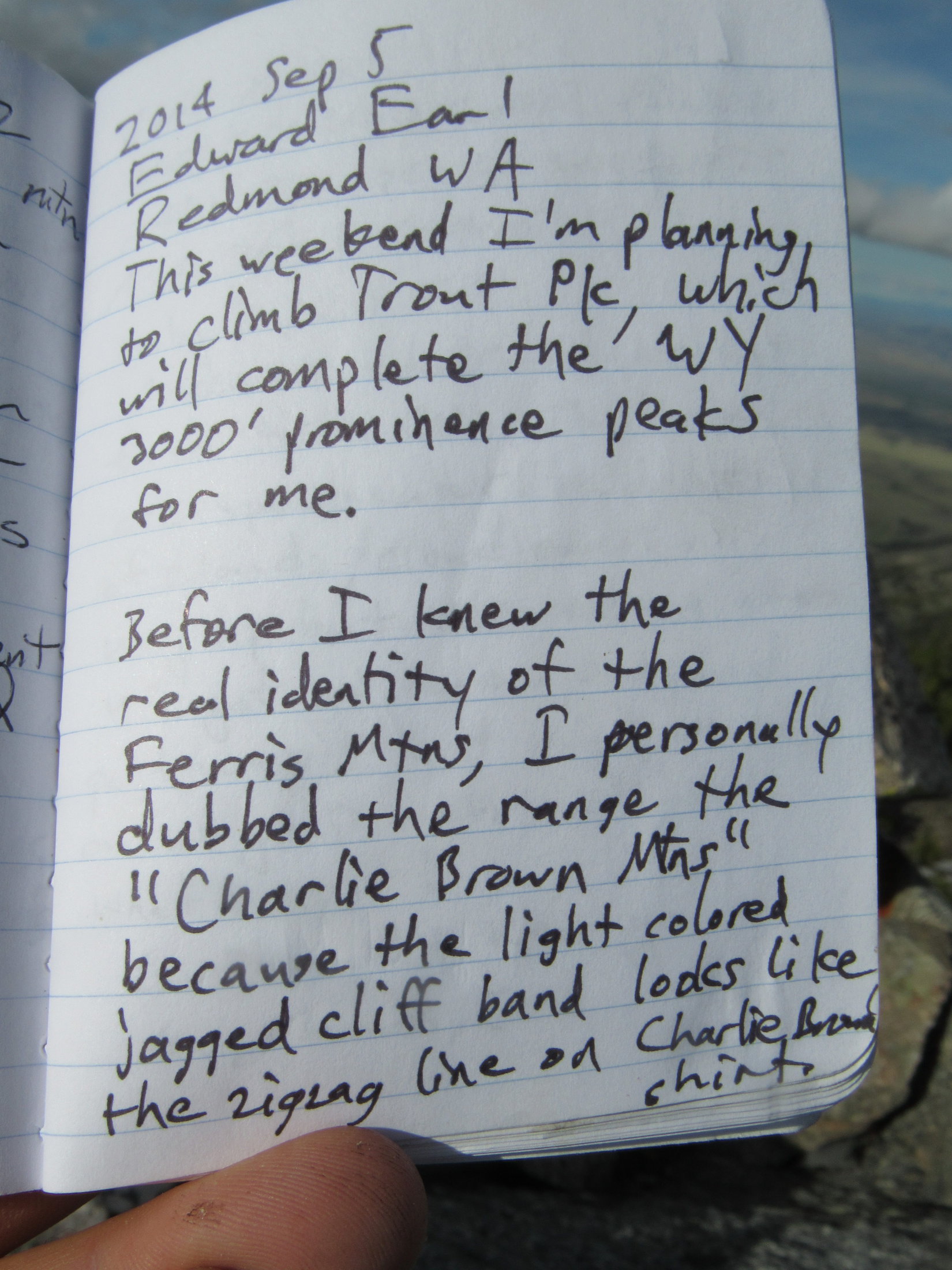
As you drive along I-80 through Rawlins WY, you can see in the distance about 35 miles north a mountain range with a very striking feature: a zigzagging white cliff band running nearly the entire length of the range from left to right. That band is the Madison formation, an upended layer of limestone which has subsequently been eroded into a series of V-notches by a succession of streams coming down from the crest above. I first noticed this mountain range in the late 1980s, and that zigzagging line reminded me of the zigzagging line across the bottom of the shirt that Charlie Brown wears. For this reason, I personally dubbed the range the “Charlie Brown Mountains”.– excerpt from Edward Earl’s trip report on his 9-5-2014 ascent of Ferris Mountain on Peakbagger.com
Rain! Not good. If it rained too hard, the dirt road would turn to mud. The G6 might get stuck way out here NW of Bairoil. Better get back to pavement, now!
It was still dark out, but Lupe was already awake. SPHP had just come to. In pre-dawn rain and fog, SPHP drove back to Bairoil. The rain had already let up to a light sprinkle, by the time Lupe reached the pavement on Hwy 73. May as well keep going.
Eight miles E of Muddy Gap, SPHP turned S off Hwy 220 onto Carbon County Road No. 499. The rain and fog were gone, but dark clouds still hid the Charlie Brown Range. It was light out now, but still very early. Lupe was ready for action! SPHP wasn’t.
Gimme a few more hours snoozing time, Loop. Need to wait a bit to see what the weather’s going to do anyway. And with that, SPHP parked the G6 and went back to sleep.
A few hours later, SPHP was ready. Time for Lupe to take on dreaded Ferris Mountain(10,037 ft.), high point of the entire Charlie Brown Range! Of course, that was provided she could even get close enough to make an attempt feasible.
The first part of the way ought to be easy enough. Lupe could follow directions in peakbagging hero Edward Earl’s trip report. She was already at the first place Mr. Earl mentioned, the sign for Pete Creek Road & Cherry Creek Road at the turn off Hwy 220.
The BLM sign off Hwy 220 at the turn onto Carbon County Road No. 499. Whiskey Peak(9,225 ft.) (L), which Lupe had good time climbing yesterday, is in view. Photo looks SW.
Mr. Earl’s trip report contained detailed instructions on how to get to Ferris Mountain. The next thing to look for was 0.9 mile from Hwy 220 along Carbon County Road No. 499, where a road branching off to the R was marked only by an unreadable sign. This intersection quickly came into view.
The intersection 0.9 mile from Hwy 220 (L) where an unmarked road branches to the R off County Road No. 499 quickly came into view. Photo looks SE.
Mr. Earl’s instructions said to go straight at this first intersection, avoiding the R turn on the unmarked road. 2 miles from Hwy 220 was another R turn, this time onto Cherry Creek Road, which was also to be avoided. Lupe and SPHP stayed on Carbon County Road No. 499 both times, and came to the Handcart Ranch sign 2.5 miles from Hwy 220.
Lupe by the unreadable sign at the first turn to the R, which is the wrong way to go. The G6 is parked along Carbon CR No. 499, which is the correct way.Stay straight on Carbon County Road No. 499. Loop is on the correct route here.At the 2nd turn to the R, which goes to Cherry Creek. Lupe did not take this side road either.Lupe at the Handcart Ranch sign mentioned by Edward Earl as being 2.5 miles from Hwy 220. There was no turn off Carbon County Road No. 499 here.These pronghorn antelope got Lupe excited!
Edward Earl mentioned a fork in the road 4.3 miles from Hwy 220. The R branch goes to a ranch, while Carbon County Road No. 499 continues to the L. Lupe arrived at this fork just as Mr. Earl said.
At the fork in the road 4.3 miles from Hwy 220. Carbon County Road No. 499 goes L here. The road to the R goes to a private ranch headquarters.
Edward Earl also said that the condition of Carbon County Road No. 499 worsened beyond this intersection. He cited frequent mud holes which were dry when he was here, but correctly surmised they were mud puddles during wet weather.
SPHP had scarcely made the L turn at the fork, when there was trouble ahead. A large mud puddle fed by a small stream completely blocked the road. Lupe and SPHP got out for a look.
Lupe inspects the mud puddle and small stream blocking Carbon County Road No. 499.
Nope! Not gonna try it! This mud puddle was as far as the G6 was going. Mr. Earl’s trip report indicated that it wouldn’t be much farther before high clearance would be needed anyway. Even though the base of the Charlie Brown Range where Mr. Earl had parked his Nissan pickup truck was still 6.5 miles away, it was going to be paw and foot for Lupe and SPHP from here. Loopster was in for a very long day!
SPHP parked the G6 in the field next to Carbon County Road No. 499, and proceeded to get ready for Lupe’s long march. The ranch headquarters was in sight from this location, not too far away. Soon a vehicle was seen leaving HQ. A couple minutes later, Lupe and SPHP met Kyra Torgensen and her son. The G6 was parked on the ranch Kyra and her husband own. Naturally, she wanted to know what was going on.
The Torgensen’s ranch HQ was in view from where the G6 was parked. Kyra Torgensen and her son soon drove up wanting to know what was going on.
SPHP explained that Lupe was here to climb Ferris Mountain. It was only another 0.2 mile to BLM land. SPHP would have parked over there, but the G6 couldn’t get past the mud puddle. Did she mind if the G6 was parked here for the day?
Mrs. Torgensen was a little reluctant at first. However, Carbon County Road No. 499 had to be a public right-of-way, which she must have known. SPHP didn’t mention this fact, though, hoping to avoid an argument. In the end, while she may not have been thrilled with the idea, Kyra Torgensen was fine with the G6 where it was. Before she drove away, she warned SPHP not to stay out too late, and to beware of wolves.
A few minutes later, Lupe and SPHP jumped the little stream, and began the long trek to Ferris Mountain (10:17 AM, 68°F). Only 0.2 mile farther, the Carolina Dog went through a gate onto BLM land. The road forked again. Following Edward Earl’s instructions, Lupe took the road to Pete Creek.
After leaving the Torgensen’s ranch, Lupe took BLM Road No. 3148 to Pete Creek. The Charlie Brown Range was still more than 6 miles away.
Lupe and SPHP weren’t worried about wolves. However, Ferris Mountain had long been the most dreaded peakbagging goal of this entire Dingo Vacation. The mountain itself wasn’t the worry. Distance wasn’t either. Forewarned by Edward Earl’s trip report, SPHP had realized all along that Lupe would likely have a 6+ mile trek just to get to the Charlie Brown Range.
The problem was the sagebrush prairie Lupe would have to cross. Two of Lupe’s nemeses might well be out there – cactus and rattlesnakes. If Lupe became scared of cacti, she would refuse to move. Rattlesnakes, of course, would be far worse.
For these reasons, SPHP encouraged Lupe to stay very close, preferably right on the road. Most of the time she did.
A few cacti did grow out on the high prairie. Fortunately, they weren’t too abundant.On the way to the Charlie Brown Range on Pete Creek Road.Wildflowers blooming on the normally arid prairie.
Fortunately, Lupe saw only a few cactus and no rattlesnakes. Meanwhile, the weather remained questionable. Dark clouds hung around. Sometimes they obscured virtually the entire Charlie Brown Range. Other times, they lifted to reveal the mountains. A significant storm was brewing off to the SE. For a while it came closer, but eventually it sailed off to the NE.
Roughly 4 miles from the G6, Lupe came to a cairn on the L side of Pete Creek Road. Edward Earl mentioned 3 cairns in this area, but the Loop only saw 1.
Lupe on the only cairn she saw on the L side of Pete Creek Road. Ferris Mountain, her ultimate goal, is straight up from Lupe’s head. Photo looks S.Lupe at the wire gate described by Edward Earl 9.2 miles from Hwy 220. The view of the mountains ahead shrouded in clouds wasn’t too encouraging at this point.
6.5 miles from the G6, Lupe finally reached the base of the Charlie Brown Range on a grassy ridge E of the mouth of Pete Creek Canyon. A white pickup truck was parked here near the edge of the forest, right about where Edward Earl must have parked his Nissan pickup. Pete Creek Road, which had been going due S for miles, turned SE here.
Lupe at the base of the Charlie Brown Range close to where Edward Earl must have parked his Nissan pickup truck in 2014. Pete Creek Road (No. 3148) (R) heads SE from here. Photo looks SE.
Lupe still had another 0.5 mile to go on Pete Creek Road along the base of the mountains. On the way, she lost 120 feet of elevation crossing the Rush Creek drainage, where she saw a salt lick noted by Edward Earl. By the time she reached a green metal gate near the mouth of Pole Canyon, she had regained all of the lost elevation and a good deal more.
Beyond the green metal gate, Loop finally left Pete Creek Road. She headed into Pole Canyon, and quickly came upon a different faint road heading up the valley.
A pronghorn antelope near Pole Creek, which is hidden in the trees. Photo looks E.Lupe reaches the green metal gate after crossing the Rush Creek drainage on Pete Creek Road. The mouth of Pole Canyon is seen beyond her. Loop left Pete Creek Road near this point. Photo looks S.Starting up Pole Canyon. Photo looks SW.
Edward Earl had followed this same road up Pole Canyon. His trip report mentioned fallen trees and a few marshy spots, but Mr. Earl had been here in September when conditions are much drier. Pole Creek was no occasional marshy spot in the middle of June, but a clear running stream. It was easy enough to wade across, however, and Lupe enjoyed the cold water.
Lupe at the first crossing of Pole Creek.
The road crossed Pole Creek more than once. Lupe also came to marshy glades, where the road hardly existed, but she could usually find it again a little higher up. After a while the road completely disappeared, lost for good.
At another Pole Creek crossing.Loop cools her paws in Pole Creek. By now, the road she had been following had faded away. So far, it was still pretty easy traveling up the R (NW) side of the canyon. The easiest routes usually weren’t right down by the creek.
At 8,450 feet, Loop arrived at the place where Pole Canyon splits. When Edward Earl had been here, only the R (W) branch had flowing water. Both branches had flowing water now. Like Edward Earl, Lupe stayed L (E). As she continued gaining elevation, the creek was increasingly hidden beneath snow.
Loop (behind the tree on the right) reaches the 8,450 foot level where Pole Canyon and the stream divide. She would follow the stream seen on the L here up the E branch of the canyon. Photo looks S.As Lupe continued to gain elevation, the creek was increasingly hidden by snow. Photo looks S.
Lupe stayed to the W (R) of the creek, but it started getting harder to make progress. The forest was dense, and the American Dingo came to more and more rocks and deadfall. The canyon sides steepened, becoming more difficult to traverse. SPHP decided Loop might have an easier time up on the ridge W of the creek.
For a while, leaving the canyon seemed like a good decision. Lupe had no problem reaching the ridgeline. It went straight S rising relentlessly at a pretty good clip, but there was less deadfall to deal with. Sometimes there was even some open ground. When she did come to rock formations, they usually weren’t much trouble to get around. Lupe gained elevation rapidly.
After abandoning the canyon to get up on the ridge to the W, Lupe gained elevation rapidly. Here she is perched on the largest rock formation she had to maneuver around in the early going. Photo looks N.Terrain like this open spot on the ridge was a lot easier to deal with than all the rocks and deadfall in the canyon Loop had left behind. Photo looks S.
It was a long way up. Lupe gained lots of elevation, but the ridge started getting ever steeper and rockier. Huge rock formations appeared above. Looper ended up on steep slopes of broken rock interspersed with spruce trees. This was challenging terrain. SPHP began to fear there wouldn’t be a way to the top.
Lupe had gained a lot of elevation, but the ridge route became increasingly challenging. Lupe found herself on steep slopes of broken rock interspersed with spruce trees. This was slow going. Photo looks SSE.
The ridgeline had basically disappeared. Lupe now seemed to be going straight up the N face of a mountain. She needed to get to easier terrain. SPHP led her up a very steep rocky chute toward a forested saddle between two massive rock formations.
Loop never made it to the saddle. Everything got so steep, progress ground to a halt. At the top of a long, narrow snow bank, SPHP realized that even if Loop could get up to the saddle, she probably didn’t stand much chance of getting over or around the giant rock formations towering above. She would be trapped between them.
Lupe at the top of the snow bank where SPHP realized she needed to down climb and go around this part of the mountain. Photo looks N.
Lupe had to down climb. She needed to get farther E. She didn’t have to lose all that much elevation, but it took a lot of time. Fortunately, it wasn’t terribly far around the huge rock formation above her. Once she managed to get around it, things became easier. The Carolina Dog was still on steep, rocky stuff, but the route up was more manageable.
Once Lupe worked her way around to the E of the massive rock formation that had towered over her, this route up was much more manageable. Photo looks SSE.
Loop climbed and climbed. She was very high, and getting close to the top of something! Her luck needed to hold only a little longer. It did. Suddenly she was there! Lupe stood next to a wooden pole at the top of a big cairn. The views were spectacular!
Lupe climbed and climbed. SPHP could see she was getting close to the top of something. Suddenly she was there, standing on top of a big cairn next to a wooden pole! Photo looks NE.
Had Lupe arrived at the top of Ferris Mountain(10,037 ft.)? The grand views, and presence of the big cairn with the pole sticking out of it made SPHP think so.
A more careful look at the views and a glance at the topo map revealed this wasn’t the case. Lupe was already nearly as high as the true summit, but she was actually on Ferris Mountain’s most westerly sub-peak over 10,000 feet. The true summit was in view from here, still 0.5 mile away to the SE.
Although SPHP initially thought Lupe might have reached the top of Ferris Mountain here, the true summit (R), which wasn’t much higher, was actually still 0.5 mile away. Photo looks SE.
Clearly, the vast majority of the work of climbing Ferris Mountain(10,037 ft.) was done. Getting over to the true summit didn’t look hard. This appeared to be the 2nd highest point on the mountain, and an amazing place. Lupe had time to take a rest break and enjoy the views.
Looking NW along the Charlie Brown Range from the westernmost 10,000+ ft. subpeak of Ferris Mountain.The rocky crag seen below on the L is Ferris Mountain North(9,740 ft.). Far beyond it out on the prairie, part of Pathfinder Reservoir is in view. Photo looks NE.Another look NW with help from the telephoto lens.Looking down on Lupe’s route up. Pole Canyon divides near the center of the photo. Lupe had started up the R (E) branch, but soon got up on the forested ridge between the divided canyons. After that it was mostly straight on up, with a short down climb to get a bit farther E. Pole Canyon empties out onto the prairie on the R. Photo looks N.Lupe takes a break on Ferris Mountain West. Photo looks NW.
After relaxing on fabulous Ferris Mountain West, it was time to move on. The ridge Loop had to follow wasn’t difficult. Her first objective along it was a slightly lower subpeak only 0.1 mile E. She was soon there, looking down on the 9,900 foot saddle where Edward Earl had first reached the ridgeline.
The route along the ridge leading to the true summit of Ferris Mountain (R) didn’t look too difficult. Lupe’s first objective, a slightly lower subpeak 0.1 mile E of Ferris Mountain West is seen on the L. Photo looks ESE.Heading toward the 9,900 foot saddle. Ferris Mountain’s true summit (Center) is seen straight up from Lupe. Ferris Mountain Middle(10,000 ft.) is across the saddle toward the R. Photo looks SE.
Loop went down to the 9,900 foot saddle and crossed it. Edward Earl hadn’t gone all the way up to Ferris Mountain West, but the American Dingo was back on his trail again here. She was now approaching Ferris Mountain Middle(10,000 ft.), the next high point along the ridge.
Looking down on Ferris Mountain North, the rocky crag on the R, from the 9,900 ft. saddle. Photo looks NNW.Lupe approaches Ferris Mountain Middle, the next 10,000+ ft. high point along the ridge. Lupe went around the N (L) side of it before climbing up to the top from the E. Photo looks SE.
The Carolina Dog stayed high as she went around the N side of Ferris Mountain Middle looking for a way to the top. She had to get E beyond the high point before she found a route. Ferris Mountain Middle(10,000 ft.) was another rather dramatic place to be!
After circling around the N (R) side of Ferris Mountain Middle, Lupe found a route to the top from the E. This was a rather dramatic place to be! Photo looks NW.At the top of Ferris Mountain Middle. Photo looks NW.Ferris Mountain West, where Lupe had first come up, is seen in the distance slightly L of Center. Photo looks NW.
Ferris Mountain’s true summit was now no more than 0.25 mile away. A lot of time had gone by. Lupe and SPHP were anxious to get there. The terrain wasn’t difficult, so Loop made great progress.
Approaching the true summit. Photo looks ESE.
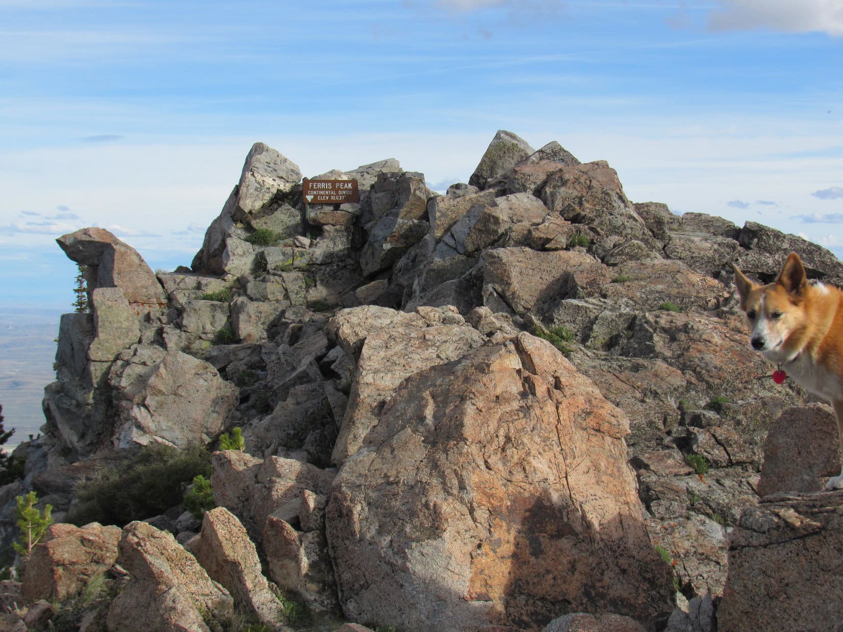
Near the very end, everything was rocky. Fortunately, it still wasn’t too hard getting around. Lupe seemed to be running out of mountain, when suddenly the summit appeared ahead. Right below the highest rocks, a metal sign said “Ferris Peak, Continental Divide, 10,037 ft.” Lupe had made it!
This what we’ve been looking for, SPHP? …. Yes, ma’am, that’s it, sweet Puppy!On Ferris Mountain at the top of the Charlie Brown Range. Photo looks S.Ferris Mountain summit. Photo looks S.
What a tremendous mountain! The views were superb. The weather was vastly improved from what it’d been this morning. Beauty shone forth in every direction in the early evening light. A glorious day! SPHP congratulated Lupe on her grand success, shaking her freckled paw.
Scrambling the short remaining distance to the highest rocks, Lupe came across two survey markers. At the very top, tucked among rocks near the metal sign, she found a plastic jar. Inside was a registry. SPHP was eager to have a look at.
Was it there? Yes, it was! Happy day! SPHP found the entry by Edward Earl.
One of two survey markers Lupe found on Ferris Mountain.Survey marker No. 2.The plastic jar containing the registry in its hiding place behind the metal sign.Edward Earl’s 9-5-2014 entry in the Ferris Mountain registry.
Seeing that Edward Earl had written about the Charlie Brown Mountains made SPHP smile. Lupe had been to quite a few mountains with assistance from Mr. Earl’s detailed trip reports. Once again, she was at the top of a mountain Edward had been to before her. Sadly, Lupe would never get to meet him.
Edward Earl had perished tragically nearly 2 years ago on 6-19-2015, drowned in the rushing Jago River in the Brooks Range in NE Alaska following two failed attempts to climb Mount Isto(8,976 ft.).
Others appreciate Edward Earl’s excellent route descriptions, too. John Stolk of Redmond, WA mentioned Edward in his registry entry dated 8-21-16.Lupe’s entry in the Ferris Mountain registry.Lupe taking it easy in the least uncomfortable spot she could find on Ferris Mountain while waiting for SPHP to finish with the registry. The registry showed that 4 other people had been here earlier today, but Loop never saw anyone.
Lupe rested among the rocks, while SPHP fiddled with the registry. When SPHP was finally done, it was time to spend a while contemplating the tremendous views.
Lupe looking beautiful in the evening light up on Ferris Mountain. Photo looks N.View to the SE.
Looking S. Edward Earl was once where Lupe was now.Final moments at the top.Looking NW from the summit. Ferris Mountain’s westernmost 10,000+ foot high point where Lupe came up is in the distance on the L.Lupe had seen these same dome-like hills from Whiskey Peak(9,225 ft.) a day earlier. Photo looks NW with help from the telephoto lens.Pathfinder Reservoir from Ferris Mountain. Photo looks NE with help from the telephoto lens.The Pedro Mountains rise on the far side of the southern end of Pathfinder Reservoir. Photo looks E with help from the telephoto lens.
All too soon, the angle of the sun insisted it was time to move on. Lupe left Ferris Mountain starting back the way she’d come up. SPHP figured the American Dingo still had some time to spare. She revisited the summit of Ferris Mountain Middle.
Lupe returns to the top of Ferris Mountain Middle. On the way back the plan was to visit Ferris Mountain North, the rocky knob on the R, too. Photo looks NW.Ferris Mountain North (R) from Ferris Mountain Middle. Photo looks NW.Ferris Mountain West (L) from Ferris Mountain Middle. Lupe wasn’t going all the way back over there on her way down.
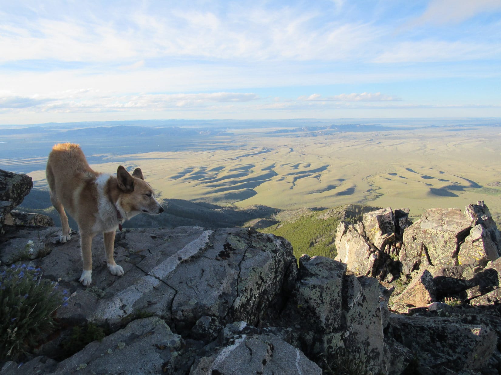
From Ferris Mountain Middle, Lupe went down to the 9,900 foot saddle. She was about to leave the mountain’s main ridgeline. Before continuing down, she took a last look at the huge expanse of prairie S of the Charlie Brown Range.
Before leaving the 9,900 foot saddle, Lupe took a final look at the huge expanse of prairie S of the Charlie Brown Range. Photo looks SW.
She then turned her attention to her final peakbagging objective of the day, Ferris Mountain North(9,740 ft.).
Looking down on Ferris Mountain North from the 9,900 foot saddle. Photo looks N with help from the telephoto lens.
Looper headed down to the 9,700 foot saddle leading to Ferris Mountain North. She went N toward the high point. As she got close, she circled around to the E where it wasn’t as steep. Lupe quickly found a rocky route to the top.
Approaching the top of Ferris Mountain North from the SE.
To the S, were the forested upper N slopes of Ferris Mountain leading to the ridge where the Carolina Dog had spent the last several hours atop the Charlie Brown Range. To the N, thirsty sagebrush prairie stretched away to distant hills. Shadows of ridges made the land look like ripples on a sea.
Lupe on Ferris Mountain North with a view of the NE side of the Charlie Brown Mountains. Photo looks NW.Ferris Mountain (L), Ferris Mountain Middle (Center), and the 9,900 foot saddle (R) from Ferris Mountain North. Photo looks SE.Looking down on the 9,700 foot saddle from Ferris Mountain North. The 9,900 foot saddle is seen up on the ridge on the L. Ferris Mountain Middle is the high point on the far L. Photo looks S.A commanding view to the N.Looking NNW.
Lupe couldn’t linger long on Ferris Mountain North. She was 2 miles from the green metal gate near the mouth of Pole Canyon. Another 7 miles to the G6. After a good look around, and a little time spent in contemplation, Lupe headed back to the 9,700 foot saddle.
Downhill all the way now! The Carolina Dog plunged N down into the E branch of Pole Canyon. The forest was a maze of 3 to 5 foot high snow drifts and deadfall timber, but this route was easier than the way Lupe had gone up. The terrain was only moderately steep, and not too rocky.
Loop soon discovered that the roughest ground was at the bottom of the canyon. For a long way, she stayed E and higher up, sometimes more than 100 feet above the creekbed. The snowbanks shrank and became less numerous, as she lost elevation.
By the time Lupe was low enough so most of the snow was gone, the deadfall wasn’t as bad either. She now made fast progress, which was a good thing. The sun, though still up, was hidden behind the mountains. Sunset couldn’t be too far off.
As Lupe drew near the point where both branches of Pole Canyon converge, the terrain changed. Lupe made her way to the bottom of the canyon, and leapt over to the W side of the creek. She soon came to the stream confluence, and had to make one more crossing. For a while she traveled down Pole Canyon staying W or NW of the stream.
To avoid the larger stream crossings and swampy ground closer to the mouth of Pole Canyon, Lupe eventually got up on the side of the ridge to the NW. Nearing the base of the Charlie Brown Range, she reached the ridgeline. The sun was down, the land dark. Thin clouds glowed brilliantly orange in a pale sky.
The colorful display faded to gray. Lupe managed to reach the green metal gate before it was too dark to see. Still 7 miles to go, but Loop had made it to Pete Creek Road. After crossing the Rush Creek drainage, the road turned N. All gently downhill from here.
Lupe and SPHP marched away from the Charlie Brown Range, never looking back. Only blackness was behind. Ahead, distant headlights on Hwy 220. The infinite universe glittered above.
Every now and then Lupe heard something, and went racing away into the night. Antelope? Rabbits? No telling. Fortunately, the luck of the Dingo held. She always came streaking back, panting happily. No cactus had stabbed her. No rattler had bit her. No wolves had devoured her.
Ferris Mountain had been a fabulous day! Yet, things don’t always go one’s way. Luck can run out. Perhaps weariness, or the silent black night was to blame, but during the long trek back it was hard not to think about another adventurer who had come this way. An adventurer who ultimately helped make this day a success for beloved Lupe, but whose luck had run out nearly 2 years ago.
It was hard not to ponder the life and times, and tragic fate of Edward Earl. (12:05 AM)
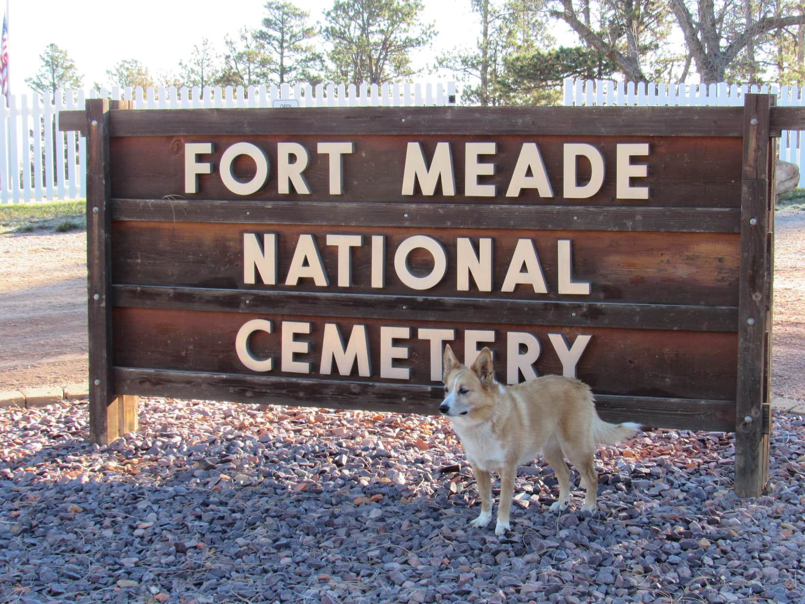
Start – Fort Meade National Cemetery near Sturgis, 8:46 AM, 35°F
Lupe arrived at Fort Meade National Cemetery the day after Veteran’s Day. The cemetery was officially closed this time of year. Loop wouldn’t have gone in even if it wasn’t. Some might consider an American Dingo prancing around a cemetery disrespectful, even though she wouldn’t have done any harm.
Lupe arrived at the Fort Meade National Cemetery the day after Veteran’s day on a bright, crisp morning.
Lupe was actually here to visit a few peaks near Sturgis she’d never been to before. Once SPHP was ready, she crossed the road W of the cemetery, and started climbing along a ridgeline through a pine forest. She didn’t have far to go before reaching a broad meadow of tall grass.
W of Fort Meade Cemetery, Lupe reaches a meadow of tall grass near the start of her way up Peak 3950. Photo looks W.
In the meadow, Loop happened upon a dirt road that curved SW. She followed it higher back up into the forest. A huge dead tree had fallen over the road, blocking it completely. From the trunk of the dead tree, Lupe could see Bear Butte(4,422 ft.) off to the NE rising dramatically from the surrounding prairie.
From the trunk of the dead tree, Lupe saw Bear Butte rising dramatically from the surrounding prairie. Photo looks NE.Bear Butte’s summit is the N end of Centennial Trail No. 89 which winds 111 miles through eastern portions of the Black Hills all the way to Wind Cave National Park.
The road climbed steadily through the forest. Before long, though, the terrain began to level out. The forest became more open and park-like, and the road curved NW.
Off to the SW, it looked like there might be views from the edge of the mountain. Lupe left the road to explore in that direction. Several deer fled as she approached the edge. Loop had a nice view of the valley S of Sturgis.
Lupe came to this nice view of the valley S of Sturgis. Photo looks SSW.
Peak3950 was Lupe’s destination. The summit was only 0.5 mile NW from here. Lupe traveled NW near the sharp SW edge of the mountain. At first, the terrain was level or rolling. The American Dingo had her choice of staying in the pine forest or out on another tall grass meadow, and did some of both. Bear Butte was still in view from the meadow.
On the way to the summit of Peak 3950, Lupe spent part of her time in this big tall grass meadow, from which she could still see Bear Butte. Photo looks NE.
In the meadow, Loop came upon the road again. She followed it NW back into the forest, gaining elevation at a moderate pace. Lupe stayed on the road until she was close to Peak 3950’s summit. The final part of the climb was an easy romp through the woods.
On the road again getting close to the top of Peak 3950. Photo looks NW.
Peak 3950’s summit area was large and relatively level. The highest part was near the N end. No single point stood out as the exact location of the true summit, but Lupe was satisfied. Climbing Peak3950 had been easy and fun.
Lupe at the top of Peak 3950. Climbing the mountain had been quick and easy. Photo looks SSE.On Peak 3950’s flat summit. Photo looks E.
At the top of Peak 3950, trees hid the views in most directions. However, along the edge of the steep W slope, Lupe found rock outcroppings from which she could see the town of Sturgis.
From rocks along the W rim, Lupe could see the town of Sturgis. Photo looks WNW.Sturgis, SD from Peak 3950. Photo looks NW.A look at the downtown area with a little help from the telephoto lens. Photo looks NW.Looking W.
Lupe could also see her next two peakbagging objectives. Oyster Mountain and Sly Hill were both in sight to the NW.
Lupe’s next peakbagging objectives were in view.Oyster Mountain(4,040 ft.) is the forested ridge on the L. SlyHill(3,920 ft.) is straight up from the blue water tank on the R. Photo looks NW.
Names, dates, and initials had been carved into the rocks Lupe was standing on. One rock S of the summit area even had a whole phrase carved into it.
Many names, dates, and initials were carved into rocks along the W edge of the mountain. Someone had gone to the trouble of carving the phrase “The fear of the Lord is to hate evil.” into this rock.
Lupe lingered on Peak 3950 for a little while, but didn’t stay terribly long. She still had more peakbagging to do. After sniffing around some and enjoying the views, it was time to head back to the G6.
On her way back down, Lupe returns to the upper tall grass meadow SE of Peak 3950’s summit. Photo looks SE.
Once Loop made it back to the G6 (10:41 AM), SPHP drove into Sturgis looking for a way to Oyster Mountain or Sly Hill. A mile NW of town, a road went N over a saddle on the ridge connecting the two mountains. A mile beyond the saddle, SPHP parked the G6 again (11:10 AM, 49°F).
Lupe got out ready to climb Oyster Mountain’s NE ridge. At first, she was in a mixed oak and pine forest, but she didn’t have far to go before reaching a meadow. Bear Butte was once again in view.
Lupe at the first meadow she came to on the way up Oyster Mountain. Photo looks SW.Bear Butte(4,422 ft.) from the lower slopes of Oyster Mountain’s NE ridge. Photo looks NE.
Just like on Peak 3950, Lupe found a dirt road in the meadow which took her higher and back into the forest. Loop followed this road SW most of the way up Oyster Mountain’s NE ridge. Sometimes she had glimpses of views along the way, but usually there were too many trees to see much of anything.
The road eventually reached a saddle. Loop would start losing elevation if she stayed on the road, so she left it. She headed W, still climbing steadily.
Before long, the Carolina Dog arrived at the top of a small hill. Maybe this was Oyster Mountain’s summit? SPHP wasn’t certain. The topo map had been forgotten in the G6.
Not long after leaving the dirt road, Lupe reached the top of this small hill. At the time, SPHP thought this might possibly be Oyster Mountain’s summit. Photo looks WSW.
Lupe continued W from the small hill, and soon reached a slightly higher hill. A ridge nearly the same height was in view to the SW across a small valley. The valley drained toward a depression to the W.
SPHP remembered the topo map had shown a depression close to Oyster Mountain’s true summit. Loop ought to be able to find the summit by crossing the valley, then following the ridge on the other side.
So that’s what she did. When Lupe made it up onto the ridge, she could see I-90 in the valley below on the other side.
After crossing the small valley, Lupe climbed up onto this ridge where she could see I-90 below. Photo looks SW.
Lupe followed the ridge WNW. The terrain was nearly level for a little way, but soon Loop saw slightly higher ground ahead. The summit had to be over there.
Oyster Mountain’s S slope from the ridgeline. The summit isn’t much farther ahead in the trees on the R. Photo looks WNW.
Shortly before reaching the top of Oyster Mountain(4,040 ft.), Loop came to a sparsely forested sunny hillside. Snow was visible on Terry Peak(7,064 ft.) on the far horizon. Closer by, Lupe had a nice view of heavily forested Crook Mountain(4,930 ft.).
Snow is visible on Terry Peak’s ski runs on the far horizon (L). Heavily forested Crook Mountain is in view on the R. I-90 is seen in the valley below. Photo looks SW.
Oyster Mountain’s summit proved to be a relatively narrow, 150 foot long, flat ridge. Forest blocked any views. Minor rock outcroppings that didn’t amount to much were on the S side near the far W end.
Lupe on top of Oyster Mountain(4,040 ft.). Photo looks ESE.Carolina Dogs are rarely seen on Oyster Mountain. However, the mountain’s odd and mysterious name was part of the allure that brought Lupe here. Oyster Mountain seems an unlikely name for a mountain in the Black Hills. Lupe was about as far from an ocean here as you can get in North America.Lupe goofing around trying to be silly and dramatic from the little rock outcroppings near the W end of the summit ridge. Photo looks E.
Loopster took her only Taste of the Wild break of the day up on Oyster Mountain. The shady summit ridge was a pleasant place. Traffic noise from I-90 only partially marred the sense of isolation.
On the way back to the G6, Lupe stopped by the sunny slope E of the summit again for a final look. She then left the ridgeline, cutting down to the depression in the small valley. The depression was bone dry now, but looked like a seasonal pond forms here during wet periods.
As she left Oyster Mountain, Loop swung back by this sunny slope E of the summit for a final look. Photo looks S.Lupe near the depression on Oyster Mountain. The depression was bone dry now, but looked like a seasonal pond must form here during wet periods. Photo looks W.
After leaving the depression, the American Dingo retraced her route up all the rest of the way down. Lupe had fun running and sniffing around, but it was only 1.25 miles back to the G6. It didn’t take her all that long to get there. (1:09 PM)
Loop still had one more peak to climb near Sturgis. SPHP drove to the saddle between Oyster Mountain and Sly Hill, parking near a fence surrounding a “rubble site” (1:16 PM, 52°F). A sign nearby indicated Dingoes might not be entirely welcome on Sly Hill, the top of which was only 0.5 mile to the SE. Hmmm.
American Dingoes can be quite foxy, and the name of her objective was Sly Hill, after all. Lupe wouldn’t hurt a thing. Off she went, slinking through the forest. It didn’t take her long to reach a wide flat meadow rimmed with pines. The topo map showed this area as the true summit of Sly Hill(3,920 ft.).
Lupe at the official top of Sly Hill according to the topo map. SPHP was skeptical that this was actually the true summit. Photo looks NW.The Sly Dingo on Sly Hill feeling pretty foxy.Near the S rim of Sly Hill, a bit SW of the official summit according to the topo map. Photo looks WSW.
The topo map showed another high point on Sly Hill only 0.25 mile to the SE. High Point 3917 was supposed to be almost as high as the official summit. Maybe Lupe should go on over there to check it out while she was still in the area? It seemed like the thing to do.
Off Lupe went. She lost a bit of elevation exploring a narrower part of the ridge that forms Sly Hill. Soon Loop was approaching High Point 3917, a far smaller area that came to much more of a definite peak than the official summit. She caught a glimpse of Bear Butte as she began the short climb.
Looking back along the ridge linking Sly Hill’s official summit and High Point 3917. Photo looks NW toward the official summit.As Lupe started the short climb up to High Point 3917, she caught this glimpse of Bear Butte. Photo looks NE with help from the telephoto lens.On the way up to High Point 3917. Photo looks SE.
Climbing High Point 3917 was easy. Lupe got up on the top rocks at the foot of a big pine tree. Up until now, SPHP hadn’t been totally certain where Lupe was on Sly Hill, but the views from here confirmed her position. Parts of Sturgis could be seen, though trees obscured some of the town.
Loopster on the highest rocks at High Point 3917 on Sly Hill.Western parts of Sturgis are in view here from High Point 3917. Photo looks S.Looking SE from High Point 3917. A small portion of eastern Sturgis is in view on the R.
Lupe’s exploration of Sly Hill was now complete, except for one thing. On the way to the official summit shown on the topo map, Lupe had passed N of some high ground that seemed like it might actually have been higher than the official summit.
So Lupe returned to Sly Hill’s official summit, then proceeded W looking for the high ground she’d bypassed earlier. She climbed a heavily forested narrow ridge. The official summit could not be seen from here, but SPHP would have bet money that this high point to the W was actually the true summit of Sly Hill.
Lupe on top of the high point W of the official summit. SPHP would have bet money that this was actually the true summit of Sly Hill(3,920 ft.). Photo looks WNW.
Lupe had done about all there was to do up on Sly Hill. The Carolina Dog left the W high point (and likely true summit) traveling NW along the ridgeline. This proved to be the most rugged terrain she’d come to on Sly Hill. She went by several interesting rock formations on the way down.
Loop on one of the rock formations she came to on the way down. Photo looks S.On the most impressive rock. Photo looks NW.
The Sly Dingo of Sly Hill made it back to the G6 without incident (2:34 PM). At least a couple of hours of daylight remained. With visions of Lupe making one more peakbagging attempt at yet another modest, seldom-visited hill, SPHP drove Lupe to the Whitewood area. She even got close to Spearfish. However, she had no luck at any other hills or mountains.
So Sly Hill was Lupe’s final peakbagging success of Expedition No. 215. That didn’t bother the Carolina Dog at all. She didn’t mind riding around barking at deer, cattle and horses at all! She had a blast the whole time, yipping and yapping until it was way too dark to see.
Looking across the saddle separating Sly Hill from Oyster Mountain (Center). Photo looks NW.