Lucky Dingo! Australian adventurer Luke Hall was staying with her. For the second day in a row, Lupe was going to get to play host and tour guide. That could only mean another brand new adventure!
Yesterday Lupe had taken Luke up to Little Devil’s Tower(6,960 ft.) and Black Elk Peak(7,231 ft.), the highest mountain in South Dakota. Did Luke have any preference on what else he would like to see while still in the Black Hills region? Yes, he did, actually! Luke wanted to see Badlands National Park.
That was a great idea! Although the W end of Badlands National Park is only a little over an hour’s drive E of the Black Hills, Lupe had never been there before, either. Luke, Lupe and SPHP all piled into the G6. The miles flew by. It wasn’t long before SPHP turned onto Sage Creek Road a mile or two E of Scenic, SD.
The W end of the park’s N unit was still miles away, but Luke was ready to get out for a look around.
Australian adventurer Luke Hall on Sage Creek Road, a less frequented route into the W end of Badlands National Park’s most famous N unit. The park was still 10 miles away from here, but Luke wanted to take a look at the prairie lands typical of the surrounding area. Photo looks N.
Once Lupe reached Badlands National Park, a series of overlooks along Sage Creek Rim Road provided increasingly dramatic views. The first views were of Sage Creek Basin. The sharply eroded hills and bluffs typical of the Badlands were still a little way off in the distance.
Lupe at one of the first viewpoints inside the park along Sage Creek Rim Road. Photo looks SSE.The badlands scenery grew more dramatic and impressive at each succeeding viewpoint heading E along Sage Creek Rim Road. Photo looks SE.Lupe & Luke with another view of Sage Creek Basin. Photo looks SW.
Farmers, ranchers! Don’t let this happen to your property! Lupe stands next to a prime example of an erosion control program gone seriously awry. Photo looks S.
No one had to tell Lupe why this place was called the Badlands. It was easy to see there wasn’t a snowball’s chance in you know where of finding a squirrel out here! Most disappointing. Why on earth had Luke wanted to come way out to this wretched, forsaken land?
The answer was soon apparent. Hundreds, maybe thousands, of prairie dogs were living in large towns right along the road! Hundreds, maybe thousands, of fat squirrels right on the ground that couldn’t climb a tree even if there was one? It was an American Dingo’s dream come true! Badlands? Hardly, this place was a Dingo paradise! Luke was a genius!
Hundreds of prairie dogs could be seen in towns right along the road.
Shockingly, SPHP was a total spoil sport. This could have been the greatest day of Lupe’s life! Instead, SPHP refused to let her go after those prairie dogs. Not even one! It was maddening. Sure, those prairie dogs had burrows, but this ground was soft and Lupe is a great digger. It would have been the most fun ever!
The Carolina Dog had to watch as a badger scurried across the road and disappeared down into a prairie dog burrow. Luke saw a coyote nearby. Poor Lupe could only stare out the window of the G6 and dream. SPHP decided it was best to drive on.
Oh, what might have been, if SPHP hadn’t interfered!
At the Hay Butte overlook, a plaque told about how pioneers had gone to great efforts to hay the grass off of the top of a long, flat butte seen in the distance. Why they felt compelled to do so was never fully explained. The Badlands are completely surrounded by prairie. What was so special about the grass growing on that butte?
It was a mystery of the universe. Some things can’t be explained, like why SPHP sided with the prairie dogs against the loyal Carolina Dog, a lifelong friend?
A short distance E of the Hay Butte overlook, Sage Creek Rim Road ended at the paved Badlands Loop Road, which winds through the most frequently visited part of Badlands National Park. Park headquarters and most trails, overlooks, and displays are located along the Badlands Loop Road.
Lupe’s first stop traveling E on Badlands Loop Road was at the Pinnacles overlook, where a couple of short trails led away from the road down to several viewpoints. Luke went down to investigate. American Dingoes couldn’t go on any of the trails, but the views were great right up by the road.
At the Pinnacles overlook. Hay Butte is the long, flat butte in the distance on the L with clearly badlandy sides. Luke is a mere speck checking out the views from the end of the trail on the R. Photo looks SW.The view to the SE from the Pinnacles overlook revealed a sweet, happy Carolina Dog. Abundant weird landforms were seen in this same area, too. Photo looks SE.
Most of the dramatic eroded buttes and spires of the Badlands are horizontally striped with many relatively thin layers of gray, white, or pink soils. At the Yellow Mounds overlook, however, a thick lower layer of yellow soil capped with red was exposed. The grays, whites and pinks could still be seen higher up. In some of the lowest parts of this region, the mounds were completely yellow, since the overlying layers had been eroded completely away.
While the soil colors can appear more dramatic near sunrise or sunset, or especially after a rain, even in sunshine at midday the Yellow Mounds were definitely worth a look.
Luke & Lupe at the Yellow Mounds. Here the yellow soil is seen as a lower layer at the bottom of a small valley. Photo looks NW.Looking NNE directly across the same valley.Looking ENE down the same valley. More of the yellow soil is exposed here. One of the smaller lower mounds in the valley is almost entirely yellow.Yellow mounds were present on the S side of the road, too. Luke gives Lupe a lift to help get her more into the scene. Photo looks WSW.Lupe enjoyed being toted around the Yellow Mounds area by Luke. Photo looks S.
10 or 12 miles E of the Yellow Mounds, Lupe arrived at a big parking lot next to the Fossil Exhibit Trail, a short loop trail where fossils are on display as originally found. Luke went to check out the trail, while Lupe and SPHP visited with a park ranger who had just finished a talk on various fossils found within Badlands National Park.
The Badlands are full of fossil-bearing sedimentary rocks. Fossils of many extinct animals from the Oligocene epoch 23 to 35 million years ago continue to be found here, including:
Leptomeryx – a small deerlike mammal
Oreodonts – common and sheeplike
Archaeotherium – a relative of pigs equipped with sharp canines
Mesohippus – an ancestor of modern horses
Hoplophoneus – an early saber-tooth cat
Metamynodon – a massive rhinoceros
Stark views of the Badlands like this one were common along the Badlands Loop Road.People wander along the Fossil Exhibit Trail where fossils are on display as originally found. Luke took this trail while Lupe and SPHP stayed at the parking lot chatting with a ranger who had just finished a talk about fossils found in Badlands National Park.
After Luke got back from the Fossil Exhibit Trail, the next stop was at the Ben Reifel Visitor Center. Lupe couldn’t go in, but Luke and SPHP did, returning with brochures containing maps of the park. Several short trails were only a few miles away, so it was decided to go check them out.
Lupe had to wait in the G6, while Luke and SPHP went to explore the Window and Door trails.
The very short Window Trail ended at a metal railing at the edge of a deep gully. Across the gully was this view of steep, wild badlands. Photo looks E.Luke on the Door Trail, which passed through a narrow gap to reach this large area of badlands. Photo looks E.Luke farther along the Door Trail. A series of numbered posts showed the way. Photo looks SE.Door Trail. Photo looks NW.Luke stands near a twisting maze of steep, deep gullies typical of the badlands. Photo looks SE.Badlands from the Door Trail. Photo looks SE.
The Window and Door Trails provided great views of some wild-looking badlands, but didn’t take long to explore. After returning to the G6, Luke continued on to explore the Notch Trail. Meanwhile, SPHP stayed with Lupe near the start of the trail.
Lupe enjoyed being out relaxing in the dry grass, surrounded by the beauty of the Badlands.
Lupe relaxes in the dry grass near the start of the Notch Trail while waiting for Luke to return. Photo looks ESE.
Luke was gone quite a while. People who had left after Luke did started returning. When SPHP inquired, two groups they said they had been all the way to the Notch at the end of the trail. Both groups had taken 40 to 45 minutes to make the round trip.
Lupe kept waiting. Eventually Luke reappeared.
Luke returns from the Notch Trail. Photo looks SSE.
Of course, Luke had made it to the end of the Notch Trail, too. He enjoyed the walk and the views, but especially the extra time he’d spent scrambling around on the Badlands formations.
The Badlands aren’t high at all by mountain climbing standards, but scrambling among them is tricky and potentially treacherous. The very steep sides of the formations are often loose and crumbly. Exercising considerable caution, Luke had successfully made it to the top of some of the highest formations near the Notch.
Near the start of the Notch Trail. Photo looks E.View along the Notch Trail on the way to the Notch.Luke up on top of Badlands formations near the end of the Notch Trail. Photo looks SE.Looking SE. Most of the Badlands lie along a long, relatively narrow area. Views of the surrounding prairie are never far away.Looking SW. The area near the Ben Reifel Visitor Center is on the far R.Looking E.Looking NW.
It was evening and time to start back when Luke returned. SPHP drove W back along the Badlands Loop Road. Lupe saw lots of animals to bark at from the G6. Pronghorn antelope, a buffalo, and bighorn sheep all got the enthusiastic Dingo treatment as Lupe sailed on by.
Lupe got to make a few stops to enjoy the scenery along the way, too.
Scenery on the drive back W along the Badlands Loop Road.Slanting evening light highlights the sharply eroded Badlands terrain.Loopster enjoys a short outing along the Badlands Loop Road. Photo looks WNW.
The sun was sinking fast. Lupe, Luke and SPHP stopped at Panorama Point for a final look at the Badlands before it set. The evening was beautiful, and the sweeping views simply magnificent.
Approaching sunset from Panorama Point.Australian adventurer Luke Hall at Panorama Point. Photo looks E.Lupe, Luke & SPHP watched the sun set behind a distant jagged Badlands horizon.Luke takes a photo from Panorama Point before the last rays of sunlight disappear.Looking E from Panorama Point with help from the telephoto lens.Lupe’s beautiful day in Badlands National Park draws to a close.
The sun disappeared from view. Lupe’s beautiful day in Badlands National Park with her friend Australian adventurer Luke Hall was over. It was her last big adventure with Luke before he would set out for Grand Teton and Yellowstone National Parks in Wyoming.
It was sad to think that Luke would be leaving soon, but Lupe and SPHP were both glad that he had taken the time to come and visit the Black Hills and Badlands of remote western South Dakota.
Lupe at Panorama Point, Badlands National Park, 9-27-17.
Day 2 of Lupe’s 2017 Dingo Vacation to the Laramie Range, Wyoming & Beyond!
Lupe shot out into the night. No telling what hour it was. No doubt it was late, very late. Following a road to the top of Black Mountain(7,960 ft.) yesterday hadn’t been hard enough to wear the Carolina Dog out. She was all stirred up about being on a Dingo Vacation again, and had been staring out of the G6 watching the dark forest for hours. SPHP wasn’t all that sleepy, either. May as well join Looper out there.
The night air was pleasantly cool. Only a few stars could be seen through high, thin clouds. The nearly full moon was so bright, no other light was necessary. SPHP strolled S along USFS Road No. 633, while Lupe explored small fields nearby. The flowing waters of Horseshoe Creek and Lupe’s sniffing made the only sounds breaking the silence.
Forty minutes later, Lupe was back at the G6. She helped devour the rest of the leftover roasted chicken, then was finally able to fall asleep. By the time SPHP woke up again, the sun was shining. A surprisingly strong, cool breeze was blowing down the Horseshoe Creek valley. Lupe and SPHP spent a little time down by the stream. The sky clouded up.
Lupe by Horseshoe Creek. A surprisingly strong, cool breeze was coming down the valley. Photo looks S.
The wind was strong enough so making breakfast was going to be a bother. SPHP decided to skip it. The roasted chicken in the night could serve as breakfast. Lupe was raring to go, anyway. Onward!
SPHP drove toward Lupe’s next peakbagging destination, following USFS Road No. 633 back to Esterbrook. From there Lupe enjoyed a scenic ride SW on Country Road No. 5. A huge herd of beautiful cows appeared ahead right on the road! Another cattle drive, or perhaps it was the same one Lupe had passed yesterday back at Prairie Dog Hill (6,400 ft.), was going on. In any case, another enthusiastic barkfest was in order.
Once safely a few miles beyond the cattle, SPHP stopped the G6 near a big rock outcropping providing a great view of Lupe’s next challenge. Eagle Peak(9,167 ft.) loomed to the S.
Eagle Peak from a hillside near County Road No. 5. Photo looks S.Eagle Peak was Lupe’s next peakbagging challenge. With no roads or trails to follow, it would prove to be much harder than Black Mountain had been yesterday.N face of Eagle Peak. Eagle Peak is nearly 4 miles W of Laramie Peak, the highest mountain of the Laramie Range.
By 10:23 AM (67°F), the G6 was parked only a mile NW of Eagle Peak near the 3-way intersection of County Roads No. 5 & 71, and USFS Road No. 671. Lupe started out on No. 671, but quickly left it to follow a steep side road up an open slope. When the side road turned NE to rejoin No. 671, Lupe left it as well, climbing SE up into the forest.
The forest was full of cheerful yellow flowers.
Soon after Lupe departed for Eagle Peak, she found herself climbing through a forest full of pretty yellow flowers.
The climb through the forest was fairly steep. Lupe soon reached a high point where she could not advance any farther toward Eagle Peak. Gah! She was going to have to lose some of her newly gained elevation. From high rocks, a flowery open saddle could be seen below to the SE.
Lupe ultimately lost 100+ feet of elevation working her way NE through thick forest and boulders before she came to a point where she could reach the open ground safely. She then had to head S back up to the flowery saddle. Not very efficient.
Lupe reaches the flowery saddle. Photo looks S.
Great job of route finding, SPHP!
Pshaw! A minor setback. Puppy, ho! Onward!
From the flowery saddle, Lupe went SSW, skirting around the W side of another minor high point. She then turned SE, and quickly arrived at the edge of a small valley. A thickly forested hillside rose from the valley, climbing steeply toward the rocky upper NW face of Eagle Peak.
It looked like it might be possible to simply climb the NW face straight to the top of the mountain. Then again, maybe not. The rocky summit ridge was a long way up, still too far off to see details well. The topo map seemed to indicate it might be easier to approach the mountain from the SW.
High up on the mountain toward the S, an area of burnt forest was visible. Maybe Lupe should head toward that?
Beyond the flowery saddle, Lupe arrives at the edge of the small valley seen directly ahead. A thick forest rose steeply from the valley up the NW face of the mountain. The topo map seemed to suggest the easiest route to the summit might be from the SW, not the NW. For that reason, SPHP led Lupe toward the burnt area seen high up on the R (S). Photo looks SE.
SPHP led Lupe across the small valley, entering the forest. Loop traveled SSE gaining elevation steadily. The immediate goal now was to reach the burnt forest high up on Eagle Peak’s SW slope. The Carolina Dog had a good time exploring the living forest, which went on for quite a long way. She stopped for water and to relax a few times when SPHP needed a break.
Enjoying the forest somewhere on the lower NW slopes of Eagle Peak.The living forest went on for what seemed like quite a long way as Lupe headed SSE. It was too thick to permit any views of how much progress she was making.
The living forest was nice and cool, but the morning’s clouds had mostly dissipated by the time Lupe reached the start of the burnt area. The day was sunny, bright, and getting warmer. Lupe could now see more of the territory higher up. The view improved as Lupe continued climbing. The top of the mountain was still hundreds of feet higher.
Looper enters the burnt area on Eagle Peak’s upper SW slopes. She had a somewhat better view of things from here, but the top of the mountain was still at least several hundred feet higher up. Photo looks ENE.
At first the burnt area was quite easy to navigate through, but as Lupe got higher up, she started encountering more deadfall, larger boulders, and some living trees as well that made progress increasingly difficult. Lupe and SPHP turned ESE to climb more aggressively, but the terrain grew worse. Finally, it became clear that the Carolina Dog was rapidly approaching the base of a nearly vertical wall of solid rock.
By now, Lupe wasn’t too far from the S end of the mountain. SPHP had her head that way, looking for a break in the rock wall that would let her get up on top. No dice. The vertical rock wall was continuous. Lupe finally reached the S end of it. She was now quite high on Eagle Peak, and had a good view of the 2 mile long ridge far below leading SSW to Jack Squirrel Peak(8,942 ft.).
SPHP had hoped Loop would be able to follow that SSW ridge to climb Jack Squirrel Peak after summiting Eagle Peak, but that clearly wasn’t in the cards. The ridge was way too rough. Nearly all of it had burned, and there would be a ton of deadfall down there, too. No way would there be time enough to navigate through all that!
At the S end of Eagle Peak, Lupe had a great view of the 2 mile long SSW ridge leading to Jack Squirrel Peak(8,942 ft.), seen in the distance. SPHP had hoped Lupe might be able to follow this ridge to tag the summit of Jack Squirrel Peak after climbing Eagle Peak. However, it was completely clear from here that was way too ambitious, and simply out of the question. Photo looks SSW.
Of course, there wasn’t much use in worrying about Jack Squirrel Peak yet, anyway. Lupe still hadn’t found a way to the top of Eagle Peak. A quick check of the topo map suggested that maybe she could go around the S end of the vertical rock wall and find a way up along the E side?
The rock wall was only a few feet thick at the S end. Lupe could now see spruce trees growing in a corridor to the E. The initial view was encouraging. May as well try it!
Looking NNE back up at the vertical rock wall at the S end of Eagle Peak. Lupe had worked her way S to this point along the W (L) side of it without finding a way up, but maybe she could find a way up from the E (R) side? It was worth a shot!
Lupe and SPHP circled around the S end of the vertical rock wall over to the E side. It was slow going amidst large boulders, and a mix of living trees and deadfall. However, Lupe and SPHP both made it, and found there was indeed a channel of forested land rising steadily to the N on the E side.
For a short distance, Lupe stayed right along the E base of the vertical rock wall as she climbed N. However, the wall rose higher to the N, too. Lupe wasn’t making any apparent progress toward being able to get up onto it.
The terrain immediately below the wall became increasingly difficult. Tightly packed spruce trees and boulders forced Lupe E away from the wall in order to make any progress at all. Even over here, the going was far from easy. Lupe was often down in cave-like spaces between boulders, while SPHP worked up and around them. Once SPHP was up, the crafty American Dingo always found a way to bound higher, too.
As Lupe climbed, she reached the W side of another, somewhat smaller rock wall along the E side of the corridor leading higher. After following this wall N up a short distance, several breaks appeared revealing large cliffs only a few feet away, and big views to the SE. SPHP was glad when those gaps ended a little higher up, and the unnerving cliff views were walled off again.
Looking back at Jack Squirrel Peak from the corridor Lupe was following higher on the E side of the S end of Eagle Peak. Photo looks SSW.
Lupe kept climbing N, but the rock wall to the W continued to get higher, too. If only she could scramble 30 or 40 feet up the wall, she would be on top, but there didn’t seem to be a way to do it. Finally, SPHP spotted a route that might work. If Lupe could reach a small green tree a little more than halfway up, the rest should be easy. It looked feasible.
After climbing N almost as far as she could, it looked like Lupe could reach the top of this rock wall and Eagle Peak, if she could get to the small green tree seen here 25 feet above her. A crack in the rocks visible from some angles went SW from the little tree up what appeared to be an easy route the rest of the way to the top. Photo looks NW.
By the time SPHP spotted this possible route via the small green tree, Lupe was nearing a pass only a little farther N. Maybe a more certain and easier way up would be visible N of the pass? Should probably check that out first! Hopes soared as Lupe approached the pass.
The view N from the pass was a colossal disappointment. All that could be seen was a line of enormous cliffs extending along the entire E side of the mountain. The continuous rock wall to the W offered not the slightest encouragement. Forget that!
Lupe reaches the pass on the E side of Eagle Peak. The view was a colossal disappointment! All that could be seen farther N was an unbroken line of huge cliffs. Lupe didn’t stand the slightest chance of scaling the mountain from anywhere along in here. Photo looks N.
The American Dingo retreated S from the pass back down to the potential route via the little green tree. It was Lupe’s last hope of reaching the summit from anywhere along this SE side of the mountain.
Lupe and SPHP went closer to investigate. The truth was plain within only a few minutes. No, there wasn’t any way Looper could get to that little green tree. It was all an illusion. The whole foray around the SE side of the mountain had been a huge waste of time and energy.
Lupe and SPHP returned from disappointment at the N pass on the E side of Eagle Peak for a closer look at this last possible route to the top from the SE end of the mountain. SPHP quickly concluded this route wasn’t going to work either. Lupe had no hope of reaching the little green tree seen at the upper R, which success entirely depended upon. Photo looks NNW.
No hope remained over here. Lupe had to return to the W side of the mountain. Slowly, slowly, Loop and SPHP worked S back down the channel E of the vertical rock wall. Time ticked by. Lupe and SPHP made it back to the S end of the mountain, and around to the W side.
The plan once again was to stay near the base of the vertical rock wall, and follow it N until a way up could be found. SPHP was still optimistic Lupe would succeed over here, if she went far enough N.
Looking up once again at the vertical rock wall at the S end of Eagle Peak, as Lupe returned to the W side of it. Photo looks NNE.
Looper seemed happy and optimistic, too, but the slog N was painfully slow going. This high up, there were plenty of obstacles on the W side of the mountain, too. More giant boulders, more deadfall, more live trees.
On and on, yet no matter how high Lupe got, the top of the vertical rock wall was always out of reach. Sometimes not terribly far out of reach, only 40 or 50 feet in some places, but out of reach nevertheless. Frustration began setting in. Wasn’t there any way up?
As if it was needed, a new worry appeared. Off to the N was another long section of Eagle Peak’s summit ridge. It was separated by a saddle from the S end of the mountain where Lupe had been trying to get up. SPHP had tried to lead Lupe up the S end, partly because that was where the topo map showed the 9,167 ft. survey benchmark. However, another look at the map showed that both the N and S ends of the mountain had sizable areas enclosed by the 9,160 ft. contour.
Maybe the true summit of Eagle Peak was actually over at the N section of the summit ridge, instead of at or near the S section’s survey benchmark? Entirely possible. Lupe’s first view from this high up over at the N section revealed 3 vertical prongs of rock grouped close together. They looked high. Maybe higher than anything over here?
As Lupe worked her way N beneath the vertical rock wall on the W side of Eagle Peak, a new worry appeared. Even farther N, a group of 3 vertical prongs of rock came into view. They looked very high. Was the true summit of Eagle Peak actually over there? SPHP couldn’t tell, but it was certainly possible. Photo looks N.Soooo, SPHP, let me get this straight! After we’ve spent hours circling uselessly around as much of this big wretched S end of the mountain as possible, you now think maybe the summit is actually way over there?Oh, don’t mind me! Think I’ll just lay on this comfy moss in the sun and laugh for a while.
Fine, fine, Loop, just peachy fine! Have your little laugh, or big one if you like, but here’s the deal. If we can get to the top of either the S section or the N section of the summit ridge, we are going to call it good enough for Dingo work. You can then claim a peakbagging success on Eagle Peak and we can get out of here. Unless, of course, it’s completely clear from up on top that the true summit is definitely at the other section? What do you think?
OK, but I really think there’s no need to keep consulting your silly, misleading, inconclusive maps. Maybe it’s time to consult a psychiatrist, instead! You might get to the bottom of all this, if not the top.
Ha, ha! So hilarious! Come on, let’s get on with it. Either way, success or defeat, I’m about done with Eagle Peak.
Oh, maybe you still do have a marble or two left!
Lupe came close to making it. Twice she got within 20 feet or so of reaching the top of the vertical rock wall. One route looked possible, but too exposed. SPHP wouldn’t chance it. The other appeared effectively blocked by a single boulder.
Twice Lupe nearly made it to the top of the big S section of Eagle Peak’s summit ridge. Here she’s only about 20 vertical feet from being there. So close, yet so incredibly far, too!
If she could have gotten up on that wall, SPHP believed Lupe would have had an easy stroll with only minor additional elevation gain required to reach Eagle Peak’s summit. It never happened. All hope of reaching the top of the mountain’s S section of the summit ridge disappeared when the N end of it ended in big cliffs.
Attention shifted to trying to get to the top of the N section of the ridge. Unfortunately, the clearer view of it that Lupe had now was even more daunting than before.
Lupe would be approaching the 3 vertical prongs from the S where the steep rock offered little encouragement. Worse yet, what could be seen of the top of the ridge farther N looked like a narrow string of rock knobs difficult and dangerous to traverse, even if it was possible to get up there somehow. Towering cliffs were seen to the E, and it looked like there must be cliffs of lesser, unknown height to the W.
Nevertheless, staying toward the W, Lupe and SPHP headed down to the saddle leading to the N section of the summit ridge. Lupe crossed the saddle and succeeded in regaining some elevation, but as expected, there was no way to the top from here.
Lupe nears the N section of Eagle Peak’s long summit ridge. Photo looks N.
It was still entirely possible Lupe might be able to reach the top of the N section of the summit ridge from the NW. She had seen that much earlier in the day. From here, though, even trying it would mean a big down climb, and then another search for a route up working N along the W side of the long ridgeline. No way. Not today. SPHP was done.
Let’s get some photos from here Loop, and call it good.
Lupe barked happily! She was ready to call it a day, too.
Looking back at the rock wall along the S half of Eagle Peak where Lupe and SPHP had spent most of the day trying and failing to reach the top. Photo looks SE.Laramie Peak from between Eagle Peak’s N & S summit ridges. Photo looks E.Another look at Laramie Peak(10,272 ft.) from Eagle Peak(9,167 ft.). Photo looks E.County Road No. 710 winds away to the SW.Jack Squirrel Peak(8,942 ft.) with help from the telephoto lens. Photo looks SSW.
On the way back down, Lupe passed through the burnt forest again.
Lupe roaming in the burnt forest near the start of the return trip down off the mountain. Photo looks SW.Windy Peak (R of Center) from the upper W slopes of Eagle Peak. Photo looks NW.
SPHP made the mistake of leading Lupe N too soon. She should have lost more elevation first. This way the burnt forest went on and on. Maybe it was just the sense of defeat, but what should have been a relatively easy trek back, seemed much longer and steeper than the way up had been. When Lupe finally reached the live forest, it also seemed to go on forever. The American Dingo turned W, plunging relentlessly down the mountain. SPHP became afraid she was going to cliff out, but she didn’t.
Somewhere near the end, Lupe’s routes up and down crossed. At last, the Carolina Dog emerged from the forest, reaching relatively level open ground near County Road No. 710. The NW slope of Eagle Peak didn’t look all that daunting from down here.
Lupe W of Eagle Peak at the end of the day not far from County Road No. 710. Eagle Peak didn’t look all that daunting from down here. Photo looks E.
Oh, well! What was done was done. Que sera. It was over. Next time Lupe would just go straight on up that NW slope! If there ever was a next time. Defeat bred pessimism.
Lupe reached the G6 again at 6:52 PM (72°F). Denied, after 8.5 hours on a mountain only a mile away, with less than 1,500 feet of elevation gain required to summit! How was that even possible? SPHP felt sunburnt, battered, bruised, scraped, and worn out. The plucky American Dingo looked fine, but you could bet even she wouldn’t be taking any long moonlit strolls tonight!
SPHP drove around the N end of Eagle Peak heading E on USFS Road No. 671. Lupe would spend the evening at a dispersed camping site off USFS Road No. 681 leading to Friend Park near Laramie Peak.
What a gorgeous evening! On the way to No. 681, SPHP stopped briefly NE of the mountain to let Lupe out for another look. Eagle Peak stood high and wonderful, its crown surrounded by an intriguing variety of cliffs and spires. Lupe had nearly reached the top. Almost, but not quite. The lofty summit remained the domain of eagles, not dingoes.
Sometimes that’s the way it goes.
Lupe NE of Eagle Peak on the beautiful evening of 6-9-17.
Start: Hwy 87/89, 0.25 mile NW of Sylvan Lake Lodge, 9:46 AM, 46°F
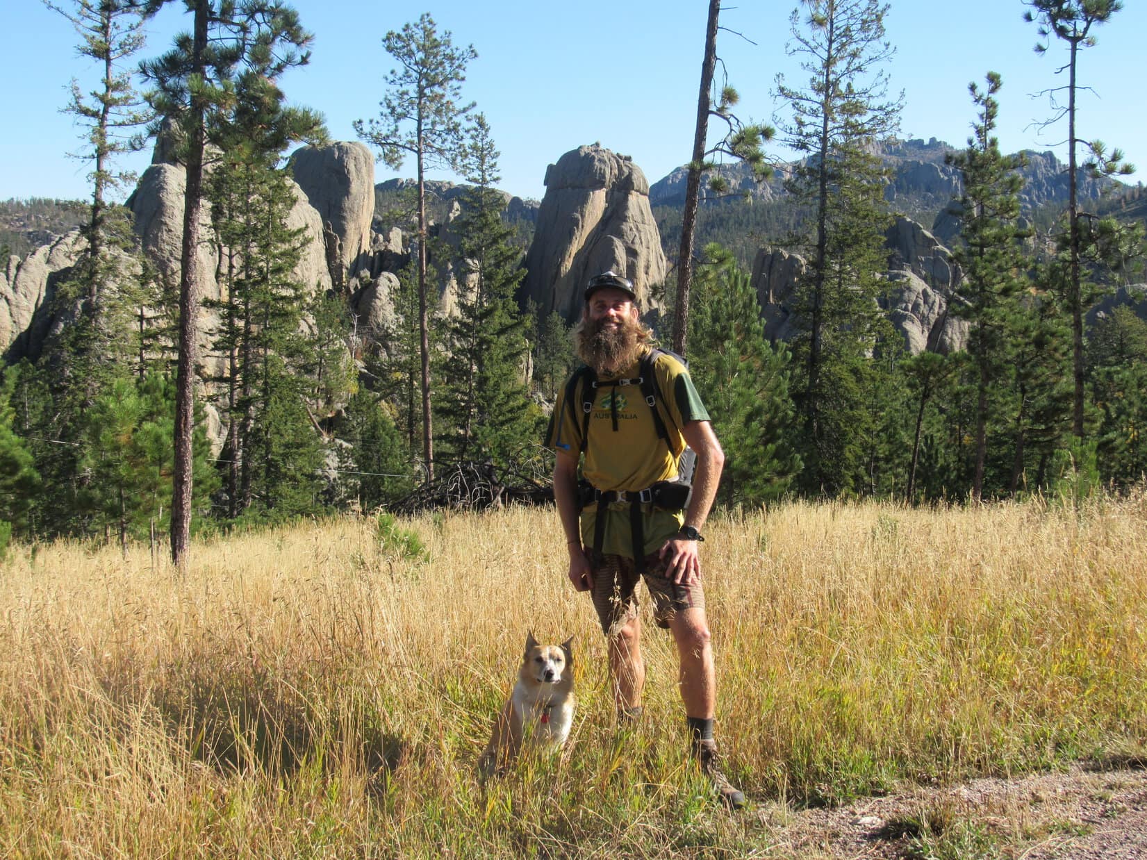
Wonder of wonders! Australian adventurer Luke Hall was actually here – in Lupe’s Black Hills of South Dakota! He’d arrived yesterday afternoon only a few weeks from the end of a 6 month trip exploring the western United States.
During his recent travels, Luke had scrambled up many notable mountain peaks, including Mt. Whitney(14,498 ft.) in California and Mt. Elbert(14,433 ft.) in Colorado, the two highest mountains in the lower 48 states. He’d spent a lot of time along the Pacific coast, and visited a great many national parks – Yosemite, Death Valley, Sequoia, King’s Canyon, Grand Canyon, Zion, Bryce, Mesa Verde, Mt. St. Helens, Mt. Rainier, Rocky Mountain – the list went on and on.
Surfing, swimming, backpacking, mountain biking, climbing – Luke had been a busy guy in 2017, but that was perfectly normal for him. In previous years, he’d explored western Canada, 10 different countries in South America, wandered through much of Europe, and toured Morocco and Egypt. He spent 2 years living and working in London, England, and another 2 years in Banff, Canada. Maybe it wasn’t so surprising that Luke had finally landed in the remote Black Hills of South Dakota after all? He did get around!
Fittingly enough, Lupe and SPHP had first met Luke Hall over a year ago on Gunsight Mountain(6,441 ft.) in Alaska. Now Luke was here to join Lupe on one of her Black Hills, SD expeditions. He had already dropped by Mt. Rushmore(5,725 ft.) on his way in, so Black Elk Peak(7,231 ft.), the highest mountain in South Dakota, seemed like a good destination. For Luke it would be an easy day, but maybe he wouldn’t mind dialing it down a notch after 5+ solid months of more strenuous adventures?
It was a lovely bright, clear day as Lupe, Luke and SPHP set out. First stop along the way was Sylvan Lake.
Lupe and Luke together again in the Black Hills for the first time since meeting over a year ago on Gunsight Mountain(6,441 ft.) in Alaska. Black Elk Peak, the highest mountain in South Dakota was today’s ultimate destination. Photo looks E.Only 10 or 15 minutes after setting out, Luke and Lupe reach the NW shore of Sylvan Lake.The small dam creating Sylvan Lake, which features a short walkway with a railing, is seen beyond Luke. Photo looks N.Looking NE across the lake.A few ducks were out on the calm water.
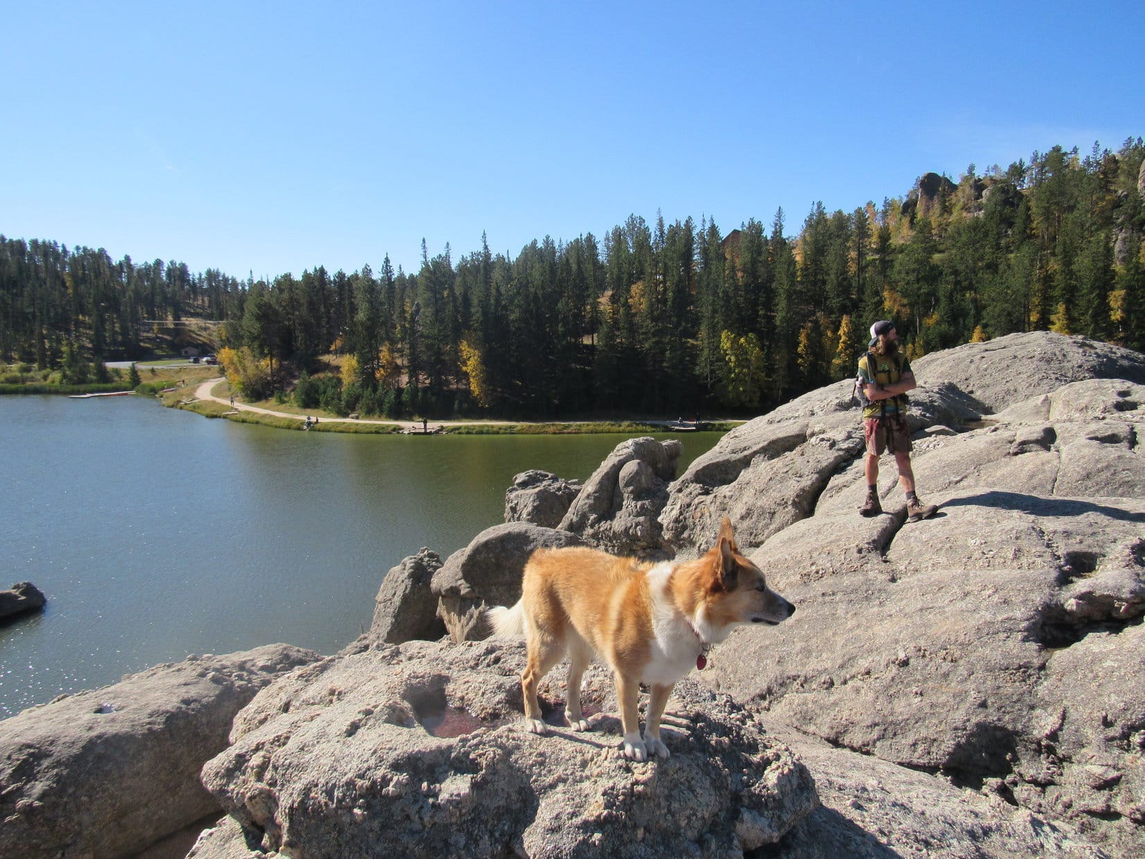
After a look at Sylvan Lake from the NW shore, Lupe, Luke & SPHP followed a trail that goes all the way around the lake back down below the dam. Lupe led Luke around to the NE & E sides of the lake.
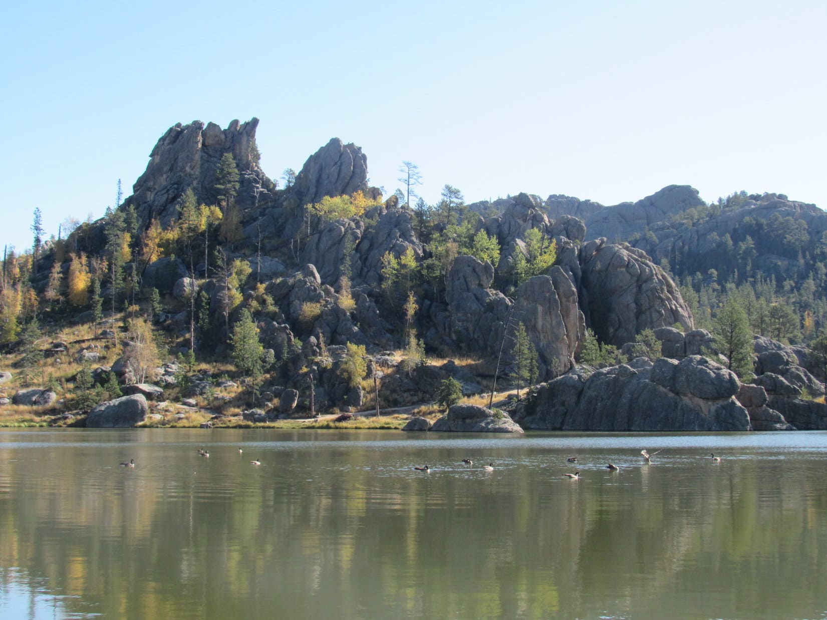
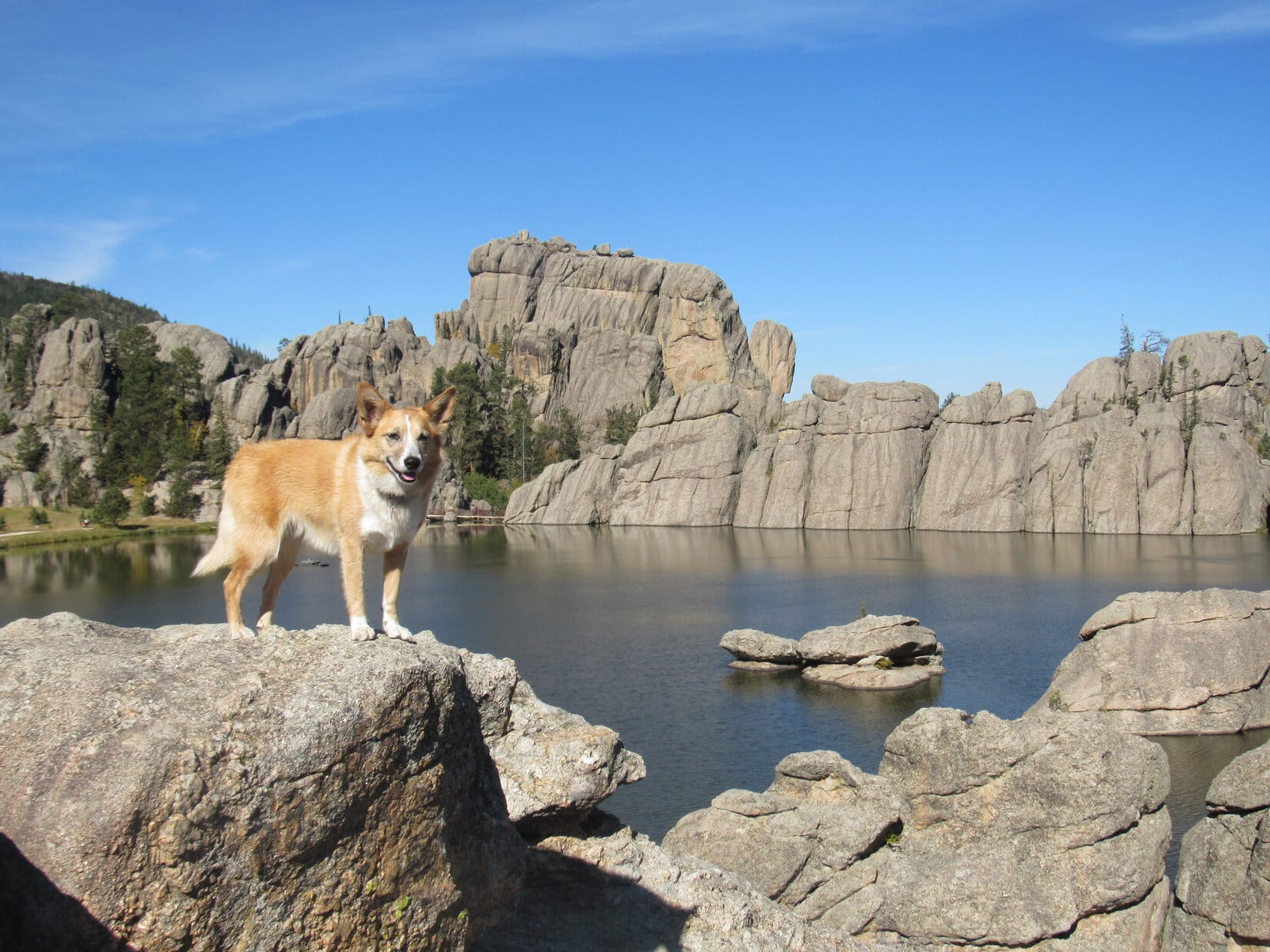
Looking SW from the rock formations along the N shore.Sylvan Lake is located at the far NW corner of Custer State Park. Though small, the lake nestles among scenic granite formations. It’s a popular destination for tourists and locals alike with a swimming beach and picnic ground. Paddle boat rentals, a convenience store and Sylvan Lake Lodge are all nearby. Photo looks W.Lupe showing her buddy Luke around Sylvan Lake. Photo looks WNW.Loopster and Luke on a large granite formation that extends out into Sylvan Lake from the E shore. Photo looks SW.Looking NNW at the N half of Sylvan Lake.
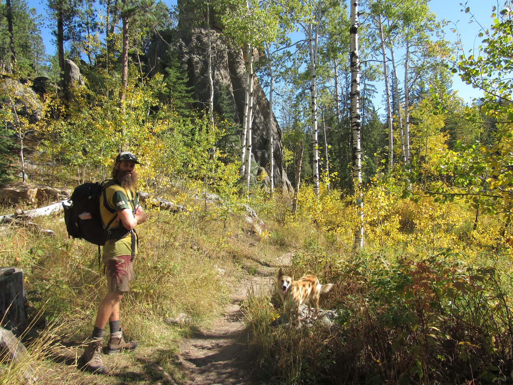
Trail No. 9 from Sylvan Lake is the most direct and popular route to Black Elk Peak, but Lupe had another trail in mind. She led Luke past the picnic ground at the SE end of the lake, and took Trail No. 4 to the Little Devil’s Tower trailhead instead.
Taking Trail No. 4 was a longer route to Black Elk Peak, but had the advantage of giving Luke a chance to climb Little Devil’s Tower(6,960 ft.) along the way, and get a close look at the Cathedral Spires(6,840 ft.), too.
Luke & Lupe along Trail No. 4 to Little Devil’s Tower.A 0.25 mile long spur trail off Trail No. 4 leads to the summit of Little Devil’s Tower. Here Lupe is near the spur trail with a view of the Cathedral Spires. Photo looks E.Luke & Looper on the way to Little Devil’s Tower. Cathedral Spires in the background. Photo looks E.
A 0.25 mile long spur trail leads from Trail No. 4 to the summit of Little Devil’s Tower. The end of the route involves a quick, easy scramble up the granite. Even small children can make it with a little supervision and an occasional boost.
Luke & Loop nearing the top of Little Devil’s Tower. Photo looks N.
Luke, Lupe and SPHP quickly arrived at the summit of Little Devil’s Tower(6,960 ft.). There were cliffs around, especially to the N, but they were of no concern. Although a bit rough, the uneven granite summit area is quite roomy.
The 360° views from Little Devil’s Tower are among the best in the Black Hills, with Black Elk Peak(7,231 ft.) to the NNW and the Cathedral Spires(6,840 ft.) to the SE being the most eye-catching.
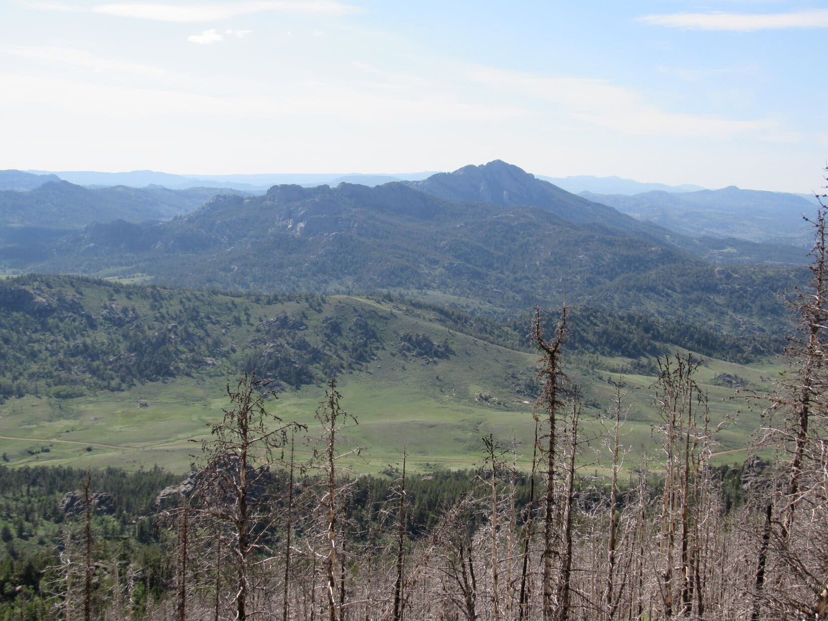
Luke and Loopster arrive at the uneven granite summit of Little Devil’s Tower. Photo looks ESE.Another view with some of the Cathedral Spires (also known as the Needles) in the background. Photo looks ESE.Lupe with the Cathedral Spires in the background. This was Lupe’s 5th ascent of Little Devil’s Tower. Photo looks SE.Although the day had started out clear and bright, quite a few clouds were around by the time Lupe reached the top of Little Devil’s Tower. A chill breeze was blowing out of the S, too. Photo looks SE.Looking NNW toward Black Elk Peak. For those with insufficient time to climb Black Elk Peak, the shorter trip on Trail No. 4 up to the top of Little Devil’s Tower can provide similarly striking views of the Black Hills.Sylvan Hill(7,000 ft.) is the long ridge 2.5 miles away with the high point poking up just R of Center. Photo looks WSW.
At first, no one else was around up on Little Devil’s Tower. It wasn’t long, though, before a couple appeared. Bryan and Rene Jobo from Franklin, Tennessee joined Lupe, Luke and SPHP at the summit.
Rene and Bryan were on vacation in the Black Hills, and apparently having a good time relaxing and hitting some of the area’s highlights. Bryan, Rene, Luke and SPHP were soon chatting pleasantly. Lupe got involved posing for photos.
Australian adventurer Luke Hall poses with Bryan & Rene Jobo from Franklin, TN up on Little Devil’s Tower. Photo looks SE.Despite a cool SW breeze, Lupe wasn’t about to get left out. Here she poses with Bryan & Rene, too.In addition to posing with an American Dingo up on Little Devil’s Tower while in the Black Hills, Bryan & Rene were looking forward to attending the Custer State Park annual buffalo roundup in a couple more days. Lupe would have loved to go to help herd buffalo around, too. Unfortunately, SPHP never seems to think that a huge buffalo herd will appreciate a noisy Dingo, so Lupe has never gotten to go.
Bryan and Rene stayed chatting with Luke and SPHP for a while, but didn’t have time to accompany Lupe all the way to Black Elk Peak. They had other adventures in mind to press on toward. Soon after Bryan and Rene said good-bye; Luke, Lupe and SPHP resumed the trek to Black Elk Peak.
Luke near the Cathedral Spires on the way back to Trail No. 4 to resume the trek to Black Elk Peak. Photo looks E.
Trail No. 4 went N past some of the Cathedral Spires, and eventually linked up with a short section of Trail No. 3, which led in turn to Trail No. 9. Near the end of a spur trail off Trail No. 9, a metal stairway hidden in a narrow opening in the granite spiraled up to a rock stairway leading to the old fire lookout tower on Black Elk Peak(7,231 ft.).
Luke reaches the old fire lookout tower at the summit of Black Elk Peak. Photo looks N.Until August 11, 2016 when the U.S. Board of Geographic Names voted unanimously in favor of the name Black Elk Peak, the highest mountain in South Dakota had been known as Harney Peak. Luke poses by a plaque at the lookout tower which has not been updated yet. In May, 2015, the South Dakota State Board of Geographic Names had proposed renaming the mountain Hinhan Kaga (Making of Owls), but that recommendation was never enacted. Lupe would have preferred Squirrel Mountain, or at least Chipmunk Mountain, but, oh well!Looking ENE from the Black Elk Peak summit. The most distant big square block of granite at Center is the back side of Mt. Rushmore.
Upon arrival at South Dakota’s highest point, Luke, Lupe and SPHP spent a few minutes out on the fire lookout tower’s W facing observation deck taking in the views. The wind had shifted to the NW by now, though, and was even colder than at Little Devil’s Tower.
View to the NNW from the fire lookout tower observation deck on Black Elk Peak.
Even Lupe was soon ready to retreat back into the lookout tower. The tower wasn’t very large inside, but Luke enjoyed exploring the winding passage down to the basement. An open doorway led out to a massive granite shoulder of the mountain immediately W of the tower. Everyone enjoyed a break in the shelter of a few pines growing out of the rock.
After snacks and water, it was time for photos from various points on the granite near the lookout tower.
Luke and Lupe NW of the fire lookout tower. The tower was last staffed in 1967. Made of stone, it has held up remarkably well during the ensuing 50 years, despite the efforts of any huffing and puffing big, bad Dingoes. Photo looks SE.Luke & Lupe up on rocks N of the tower. Photo looks NE.Adventure buddies Lupe and LukeLupe on Black Elk Peak. This was her 7th visit to the mountain. Her last visit was over 2 years ago on 9-7-15. Back then the mountain was still officially Harney Peak, as it had been since 1896. Photo looks W.Helicopters giving tours of the Mt. Rushmore area often make a pass around Black Elk Peak. Lupe loves barking at helicopters! She’s spotted one now!The view to the SE.Cathedral Spires (L) and Little Devil’s Tower (R) are in view beyond Lupe & Luke. Photo looks S.Black Elk Peak was Luke’s 3rd US State high point after Mt. Whitney in California and Mt. Elbert in Colorado. Photo looks S.
All too soon, it was time to depart. On the way back to the G6, Lupe, Luke and SPHP followed Trail No. 9 all way to Sylvan Lake. The sun was sinking, but down out of the wind the evening was pleasant.
Starting down. Sylvan Hill is seen in the distance. Photo looks SW.On Trail No. 9 before the junction leading to Little Devil’s Tower (R). On the return trip Luke & Lupe stuck with Trail No. 9 all the way, the most direct route back to Sylvan Lake. Photo looks SSW.Little Devil’s Tower from Trail No. 9. Luke & Loopster had been up there only a few hours ago! Photo looks SW.A view to the NW from Trail No. 9.Loop & Luke at the last big viewpoint along Trail No. 9 on the way to Sylvan Lake. Photo looks NNE.Australian adventurer extraordinaire Luke Hall presents the Black Hills of South Dakota!Looper takes a break on a lovely bench provided by the Highpointers Foundation. This bench is along Trail No. 9 at the first good viewpoint toward Black Elk Peak (formerly Harney Peak) on the way up from Sylvan Lake.
The light was fading fast by the time Lupe reached the G6 again at 6:45 PM (upper 50’s °F). Climbing mountains with Luke, and getting to show off her Black Hills home territory had been great fun!
The fun wasn’t over yet, though. There would be pizza and beer with Luke at home. (What, no beer for the faithful, peakbagging Carolina Dog!? No fair!) Even better, Luke was sticking around for a while. Another adventure was in store tomorrow.
It just doesn’t get any better than that!
Adventurer Luke Hall originally hails from Sydney, Australia. Lupe & SPHP were thrilled that he took the time to come pay a visit to the beautiful Black Hills of western South Dakota!Adventuring buddies Luke & Lupe on Black Elk Peak, 9-26-17


 The sun was sinking fast. Lupe, Luke and SPHP stopped at Panorama Point for a final look at the Badlands before it set. The evening was beautiful, and the sweeping views simply magnificent.


 The light was fading fast by the time Lupe reached the G6 again at 6:45 PM (upper 50’s °F). Climbing mountains with Luke, and getting to show off her Black Hills home territory had been great fun!
