Squaretop Mountain, Wind River Range, Wyoming – Part 1: On the Highline Trail from Green River Lakes to Beaver Park (7-20-18)

Day 8 of Lupe’s 2018 Dingo Vacation to the Bighorn Mountains & Wind River Range of Wyoming!

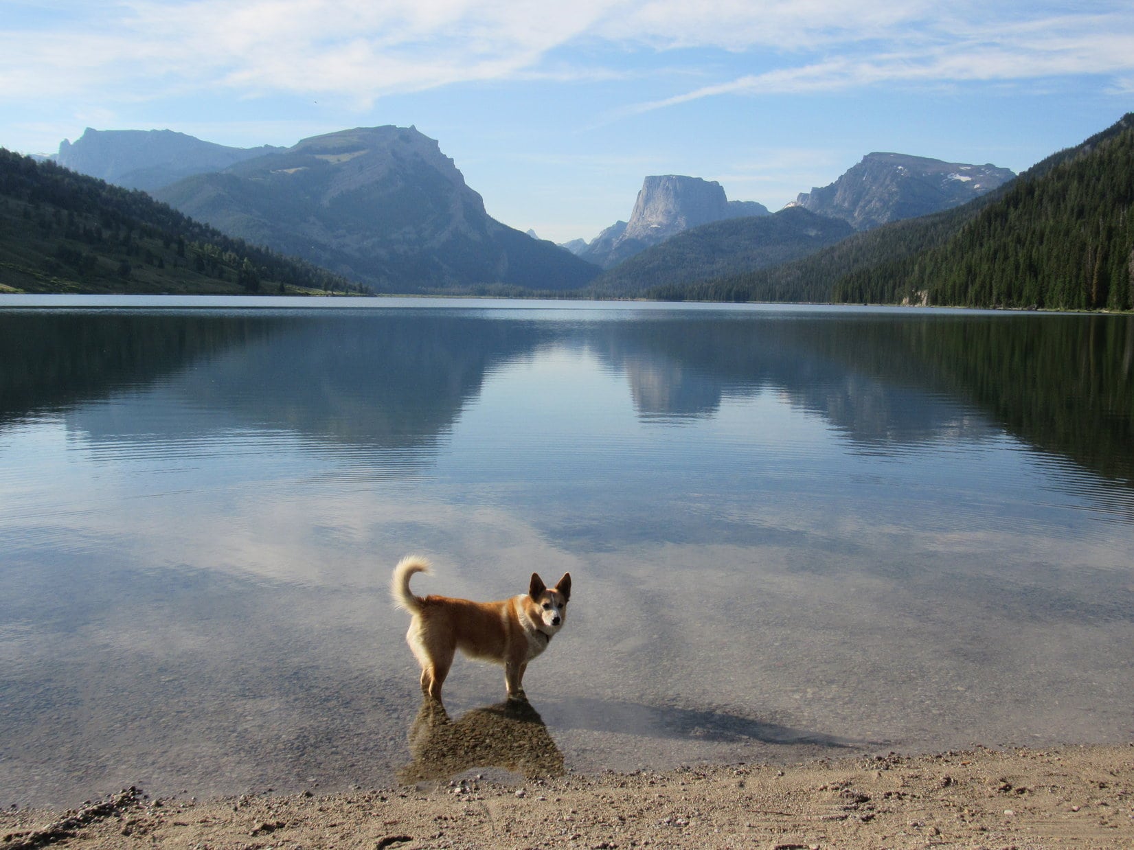
Before SPHP even got the pack ready to go, Lupe went down to the shore of Lower Green River Lake.  Having spent yesterday resting in the G6 while traveling to get here, the Carolina Dog was in fine form and great spirits.  Thankfully, her sore L front paw was no longer bothering her.

Scarcely a ripple marred the still, smooth surface of the big lake.  Beyond it, flanked by other massive peaks stood the majestic sentinel of the NW entrance to Wyoming’s rugged Wind River Range – mighty Squaretop Mountain (11,695 ft.)!

Squaretop Mountain (R of Center) from Lower Green River Lake. Photo looks SE.

Lupe had been here before.  In 2015, she had taken the Highline Trail on a reconnaissance mission to see if she might be able to climb Squaretop someday.  SPHP had an old book, Wind River Trails by Finis Mitchell, in which Mitchell described a route to the summit from Beaver Park.

Loop’s 2015 reconnaissance had only been a day hike.  She did make it to Beaver Park, but what she had seen wasn’t promising at all – glimpses of giant vertical rock walls soaring more than 2,000 feet above and beyond a densely-forested ridge, the top of which was itself 1,200 feet higher than Beaver Park.

That hadn’t been the end of it, though.  Lupe returned to Green River Lakes in 2017 and took an alternate route up to Porcupine Pass.  SPHP thought maybe she could get to the top of Squaretop Mountain from there, but Loop only made it as far as New Benchmark (11,850 ft.) where a huge, steep snowbank blocked further advance.

In Wind River Trails, Finis Mitchell insisted the route up Squaretop from Beaver Park was “not difficult”.  Finis claimed to have taken 4 year olds up the mountain.  So now, 3 years after her initial reconnaissance, Lupe was back to see if she could find Mitchell’s route!

Still looks impossible, but what are we waiting for? I’m already 7!

7-20-18, 8:28 AM, 59°F – After reading Finis Mitchell’s route description one last time, SPHP left the book in the G6.  All systems go!  It was on!  Lupe headed for the footbridge over the Green River close to where it left Lower Green River Lake.

There’s the bridge over the Green River! It’s just downstream of Lower Green River Lake. Photo looks E.

A year ago, there had been signs warning that a bridge over Clear Creek near the far end of the lake had been wiped out by flooding.  Luckily, no such signs were seen today.

This bridge provides access to the Highline Trail (No. 094)! Photo looks NNE.

After crossing the bridge, Lupe picked up the Highline Trail (No. 94), which would take her all the way to Beaver Park.  For the first couple of miles, the trail ran along the lower slopes of a mountainside paralleling Lower Green River Lake.  Views of the lake, Squaretop Mountain, and all the neighboring peaks were absolutely grand.

(Note: The Highline Trail runs the length of the Wind River Range.)

Starting for Squaretop Mountain (Center) on the Highline Trail. Photo looks SE.
Halfway along Lower Green River Lake. White Rock (11,284 ft.) (L) and Squaretop Mountain (Center). Photo looks SE.

Lupe had a blast exploring the mountain slopes near the trail.  Almost before she knew it, she was getting close to the S end of Lower Green River Lake.  She passed a junction with the Clear Creek Trail (No. 184).  Shortly thereafter, after going through a stand of tall bushes, Loopster arrived at the new bridge over Clear Creek.

S end of Lower Green River Lake. Squaretop Mountain (L). The Bottle (11,480 ft.) is the rectangular pinnacle at Center. Photo looks SSE with help from the telephoto lens.
Loopster about to cross the new bridge over Clear Creek. Photo looks SE.

Despite no Dingo level pawrails, Lupe had no problem crossing the Clear Creek bridge.  The Highline Trail was now on low, flat terrain.  Soon the Green River was in view again, tranquilly meandering down from Upper Green River Lake.  Another bridge over the Green River was ahead.

The next bridge over the Green River between Upper & Lower Green River Lakes comes into view. Photo looks S.

This next bridge provided access to the Porcupine Trail (No. 137), which Loop had taken to Porcupine Pass last year, or to the Lakeside Trail (No. 144), an alternate route along the W shore of Lower Green River Lake going back to the trailhead.  Lupe did not need to cross it.

Looper skipped this second bridge over the Green River, staying on the Highline Trail. Photo looks SW.

Beyond the bridge, the Highline Trail left the Green River, veering E off into the forest.  Lupe followed it over a minor ridge.  A mere 0.33 mile from the bridge, Upper Green River Lake came into view.

Upper Green River Lake is much smaller than the lower lake, only 7 feet higher, and equally exquisite. Photo looks S.

3 miles from the trailhead now, taking a break somewhere along the shore of the incredibly beautiful upper lake sounded like a great idea.  The Highline Trail was about to cross a marshy area here, so Lupe left it to follow a short spur trail S along the lake’s NW shore.

Squaretop Mountain (L of Center) from Upper Green River Lake. Photo looks SSE.
Squaretop Mountain (L) and The Bottle (R) from Upper Green River Lake. Photo looks SSE with help from the telephoto lens.

The views were stunning, but something else soon became the focus of Lupe’s attention.  A flotilla of 15 ducklings came paddling along close to the shore led by their mama.  A charming sight, they seemed to be thoroughly enjoying a mid-summer float trip on Upper Green River Lake.

Mama duck, admiral of a 15 duckling fleet, came paddling by.
These lucky ducklings had a mama with a keen eye for choice real estate. She could hardly have chosen a more beautiful home for her brood.
Common Goldeneye or perhaps Barrow’s Goldeneye?

After entertaining Lupe for a while, the duck display paddled onward.  The American Dingo moved on, too.  She returned to the Highline Trail, which now proceeded S above the E shore of Upper Green River Lake.

Heading S past Upper Green River Lake. Photo looks S.

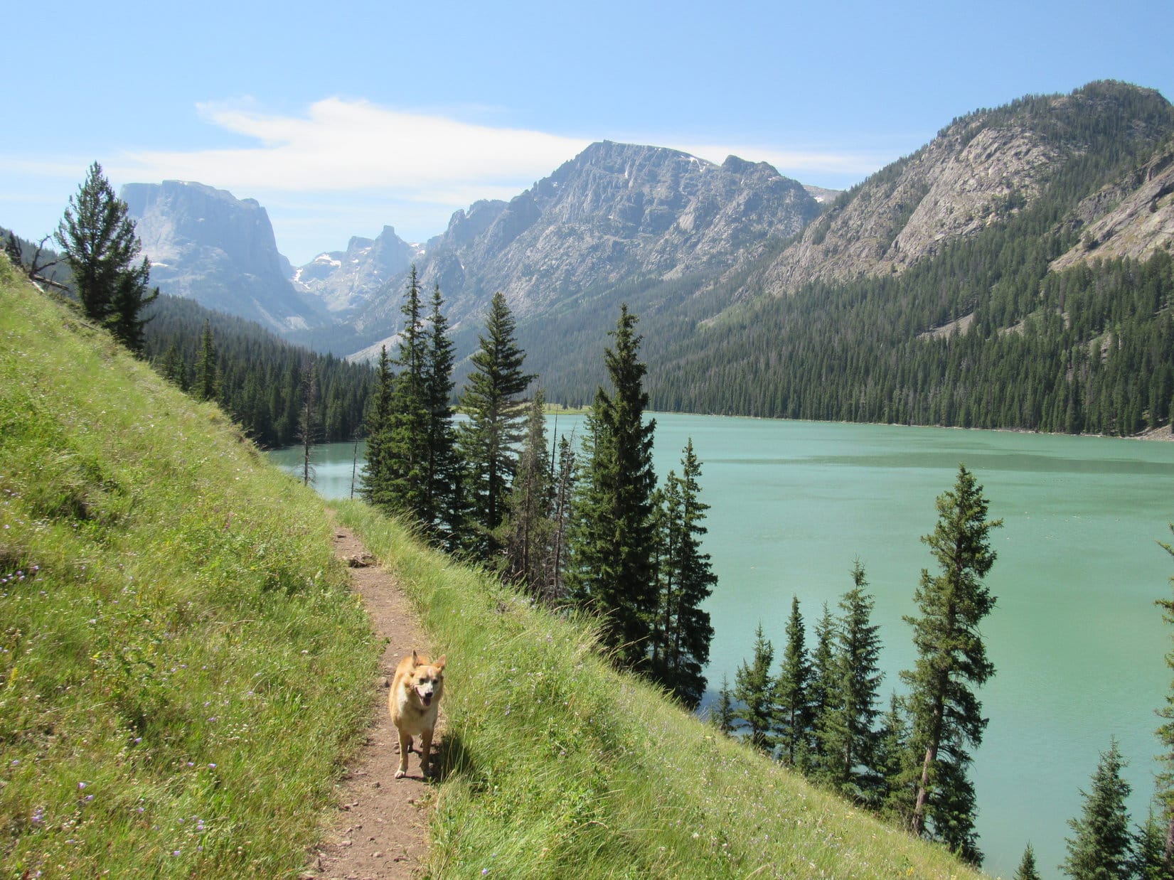
Once past Upper Green River Lake, the trail continued S up the Green River valley.  Sometimes the river was in view, and occasionally the Highline Trail even went right by it.  Other times, the river was farther away.  Most of the time Lupe was in the forest, but clearings provided lovely views of Squaretop Mountain, and allowed the American Dingo to gauge her progress.

Lupe cools off in one of many small streams that cross the Highline Trail.
Squaretop Mountain from the Green River Valley. Photo looks S.
Same view with help from the telephoto lens. The Bottle is on the R.
Looking W across the valley.

The trail sometimes went up or down, but net elevation gain was almost negligible.  The day was gorgeous, and the trail began to get busy.  SPHP occasionally stopped to chat briefly with passers-by.  Lupe stayed busy checking trees for squirrels.  The view of Squaretop began to change as the Carolina Dog got closer.

Getting closer, but still 4 miles to Beaver Park! Photo looks S.
The Green River is so beautiful! It’s got that pale, glacial look to it. Photo looks S.
A bend in the Green River. The Bottle is on the L. Photo looks SW.

Approaching Squaretop, the Highline Trail started bending toward the SE.  It stayed in the forest and began to gain elevation.  The Green River was now well below the level of the trail.  Finally the river began to get closer again, and came into view down a steep embankment.  Lupe left the trail and went down to the river.

This was a favorite spot!  Lupe had stopped here in 2015, too.  The Green River was much higher today.  The river poured down a series of rapids past a large rock midstream and disappeared into the forest below.

Loop at her favorite spot along the Green River.
These rapids are down a steep embankment next to the Highline Trail.
The Green River disappears into the forest after flowing around the big rock on the R.

The weather was perfect!  Early afternoon and Beaver Park wasn’t that much farther.  2 or 3 miles maybe?  No more than that.  A break, a nice long one, at this gorgeous spot sounded wonderful!

Lupe rested in the shade of a spruce tree, listening to the mesmerizing roar of the water while snapping at flies and ants.  SPHP dangled a foot in the frigid river until bones ached with cold.  Then the other foot took a turn at suffering, while the first one basked in warm sunshine.  Rinse and repeat, literally, over and over again.

SPHP counted how many times short sticks swirled around in an eddy before the current caught them and they sailed downstream.  Lupe dozed.  The Green River swept relentlessly, hypnotically, by.The river wasn’t the only thing sweeping by.  Time flowed relentlessly along as well.  An hour and 40 minutes vanished, before SPHP finally shook off a lethargy induced by the idyllic setting.  Puppy, ho!  Onward!  But the time spent along the bank of the Green River had sure been splendid.

Lupe returns to the Highline Trail. Granite Peak (9,892 ft.) dead ahead! Photo looks S.

At intervals, Lupe had come to various small streams which crossed the trail.  None had been even close to large enough to cause any problems.  All had merely been places where Loop could get a refreshing drink and cool her paws off.  However, as she was getting close to due E of Granite Peak, she came to two much larger streams in rapid succession.

The first was Elbow Creek.  SPHP didn’t remember crossing any major streams in this area back in 2015, but the Green River was running much higher now than back then, so perhaps these tributaries were also commensurately larger?  Looper was reluctant to ford the scary stream, but after SPHP started across, she ultimately made a successful soaking dash for the opposite bank.

The glow of this success was immediately extinguished upon reaching Pixley Creek minutes later.  Pixley Creek was 20 feet across!  Even at its deepest the stream was only knee deep on SPHP, but the water was fast and powerful.  After hesitating, SPHP waded in.  The force of the water was strong enough to make it doubtful Lupe could be carried across without falling, as had happened while attempting to cross Porcupine Creek last year.

SPHP managed to ford Pixley Creek, but Lupe hadn’t dared to follow this time.  Full of separation anxiety, she ran back and forth along the N bank searching for a way, but it was all too deep and frightening.  She finally sat in the tall grass peering across the stream at SPHP pleading for help.

Desperate not to be left behind, Lupe pleads with SPHP for help crossing swift-flowing Pixley Creek. Only a fraction of the stream’s width is shown here.

SPHP was convinced Lupe would be fine if she swam across herself, but no amount of coaxing could induce her to enter the stream.  Pixley Creek was frigid, over her head, and simply too terrifying.  In all fairness, if the situation had been reversed, no way would SPHP have done it either.

Downstream of the Highline Trail, a single log bleached white by the sun was stretched out across the entire width of Pixley Creek.  The log wasn’t terribly wide, especially near the S bank.  The danger was that if Lupe fell off it, the stream would instantly wash her into a logjam of sticks, branches and other logs immediately downstream.

When nothing else worked, SPHP reluctantly pointed the white log out.  Lupe caught on instantly!  While SPHP looked on with trepidation, the Carolina Dog raced across without the slightest problem.  Worked great, but SPHP still didn’t like it.  The what if was too terrible to think about.

At any rate, Lupe was safely across Pixley Creek.  The trail continued S up the Green River valley.  Sometimes it wound fairly high up into the forest.  Sometimes it went right along the Green River.  SPHP made one mistake leading Lupe down a short side spur that ended at the river.

Continuing up the Green River valley S of Pixley Creek. Photo looks S.
SPHP made a mistake going down to the river here. The Highline Trail actually stayed up in the forest. Photo looks S.

The Highline Trail was in the forest up on a mountainside when Lupe went around a sharp bend and saw a bridge over the Green River.  The bridge was a welcome sight.  Beaver Park was close at paw!

The footbridge over the Green River near Beaver Park. Photo looks SE.
Crossing the Green River. Photo looks NE.
This is how river crossings are meant to be!
Looking up the Green River from the bridge near Beaver Park.
Looking downstream.

Once across this last big bridge, Lupe was actually on an island.  A short distance farther on the trail brought her to a little bridge across a small side channel of the Green River.  Beyond this little bridge Lupe entered Beaver Park again for the first time since 2015.

Crossing the little bridge over the side channel. The open meadows of Beaver Park are already partially in view beyond the trees. Photo looks SW.
Beaver Park. Parts of Squaretop Mountain are visible beyond the near ridge. Granite Lake is hidden up on the ridge. Granite Peak is on the R. Photo looks WNW.

It was 5:30 PM when Lupe reached Beaver Park.  The Highline Trail had been busy all afternoon.  Yet no one was at Beaver Park.  A single tent was set up near a small grove of big pines near the S end, but nobody was there at the moment.

W of Beaver Park was the same 1200 foot high forested ridge Lupe had seen in 2015.  Towering portions of Squaretop Mountain loomed above and beyond it.  The original plan for the day had been to camp up on that 1200 foot high ridge by Granite Lake, which couldn’t be seen from here.  Camping up at the lake would save hours and all that elevation gain tomorrow when Lupe hoped to climb Squaretop Mountain.

However, it had been a long march from Lower Green River Lake carrying the pack, something on the order of 11 or 12 miles.  SPHP was tired.  Lupe was ready to call it a day, too.  Would have been better to get here earlier.  Too much time had been allowed to slip away while relaxing by the Green River rapids.  SPHP didn’t know of any trail up the ridge.  A bushwhack might easily consume hours.

It turned out that much of Beaver Park was lumpy, boggy ground.  The lone tent already set up at the cluster of pines occupied about the only really dry, level place.  A reasonably acceptable spot was found about 80 feet N.  SPHP set up Lupe’s new Marmot tiny house.

Lupe by her new Marmot tiny house in Beaver Park. Photo looks NE.

The sun was barely down behind the mountains when Lupe and SPHP crawled into the tiny house to hit the hay.  Smart to get as much rest as possible, but making Beaver Park base camp instead of Granite Lake was a major mistake.

It wouldn’t be the last.

In a contemplative mood the evening before what was likely to be Lupe’s final chance to climb Squaretop Mountain 7-20-18

Links:

Squaretop Mountain, Wind River Range, Wyoming – Part 2: Beaver Park to the Summit (7-21-18)

Next Adventure                    Prior Adventure

Green River Lakes, Squaretop Mountain & The Highline Trail to Beaver Park (8-30-15)

Striving for Squaretop Mountain, Wind River Range, WY – Part 1: Green River Lakes to Porcupine Pass (7-13-17 & 7-14-17)

Striving for Squaretop Mountain, Wind River Range, WY – Part 2: New Benchmark – Victory & Defeat! (7-15-17)

Striving for Squaretop Mountain, Wind River Range, WY – Part 3: The Dome Peak Salvage Operation (7-16-17)

Want more Lupe adventures?  Choose from Lupe’s 2018 Dingo Vacation to the Bighorn Mountains & Wind River Range in Wyoming Adventure IndexDingo Vacations Adventure Index or Master Adventure Index.  Or subscribe free to new Lupe adventures.

Black Hills, SD Expedition No. 245 – Peak 5438 (1-15-19)

Start – 9:56 AM, 27°F at the junction of Vanocker Canyon Road & USFS Road No. 135.2C

Snowier than SPHP expected.  Chillier, too!  Not even above freezing yet, though the day was supposed to warm up nicely for January.  Lupe was more than a mile S of the turn to Veteran Peak (5,333 ft.) at the start of a snowy side road off Vanocker Canyon Road.  An old marker declared this as USFS Road No. 135.2C.

Loop had been bored, bored, bored for days on end.  Chilly and snowy didn’t matter.  She wasn’t going to miss out on an expedition!  Conditions really weren’t bad at all.  Besides, one never knows how long it might be before the next chance for an expedition would come this time of year.

Lupe led the way past a couple of gates, proceeding N up a valley.

Chilly? Snowy? Forget it, SPHP! You’re not backing out now. We’re doing this! Lupe at the start of USFS Road No. 135.2C. Photo looks NW.

The snow was a good 6″ deep, loose and fluffy where there weren’t any tracks, crunchy and hard where there were.  The valley soon widened out.  The sun was brilliant.  SPHP stopped to shed a layer.

The valley widened out. The brilliant sunshine felt warmer than the temperature indicated. Photo looks SSE.
Looking farther up No. 135.2C from the same spot. Photo looks NNW.

Looper’s peakbagging objective for the day was Peak 5438.  According to Lists of John, the mountain has 548 feet of rise (prominence), quite good for a Black Hills peak.  Peak 5438 was less than a mile W of the snowy valley where Lupe was now, but a high ridge and another valley were between here and there.

No. 135.2C might eventually take Loop to the top of the ridge and around the N end of the valley to the W, but perhaps a more direct route could be found?  As Lupe headed up the valley, SPHP watched for an easy way up the ridge to the W.

Continuing up the valley on No. 135.2C. Photo looks NW.

After more than 0.5 mile on No. 135.2C, the last remaining tracks in the snow veered W off the road.  They started up the ridge toward a big pine tree with a curved trunk.  Why not?  Maybe this was the shortcut the American Dingo was looking for?  Lupe followed the tracks.

Leaving USFS Road No. 135.2C to start up the ridge to the W. Photo looks WNW.

The tracks ended before Lupe even got to the deformed tree.  The snow was deeper off the road, more like a foot.  The slope wasn’t all that steep, however, and Looper only needed to gain 200 feet of elevation.  So she kept going, and before long reached a big rock on a rounded edge where the terrain was leveling out.

Heading up the snowy slope. The snow was hard enough to support Looper’s weight. Photo looks S.
On the big rock near the start of flatter terrain. Photo looks ESE.

As shown on the topo map, a higher part of this ridge was visible off to the SW.  Loopster traveled W or WNW from the rock, still gaining some elevation.  The goal was to get to the other side of this ridge, where she ought to be able to see both Peak 5438 and the intervening valley.

From close to the big rock, a higher part of this ridge was visible between the trees. Photo looks SW.

Crossing the wide ridge, the Carolina Dog came to long open areas full of snow.  Logging or other minor roads may have been hidden beneath it.  Beyond these openings, Lupe got her first glimpse of Peak 5438.

Crossing the ridge, Lupe came to long snowy openings in the forest. The snow may have been concealing logging or other minor roads. Photo looks SSW.
From the W side of the first ridge, Peak 5438 was in view. Photo looks WSW.

The E slope of Peak 5438 looked steep, and the intervening valley was deeper than expected.  Not wanting to lose so much elevation crossing this next valley, Lupe turned N following the W side of the ridge she was already on.  Beyond a high spot, she came to the biggest opening yet in the forest.  Again it looked like a road must have been buried beneath the snow.

At the big snowy opening. Photo looks SE.

Lupe did not attempt to follow the hidden road.  She continued N along the W side of the ridge.  Dog-hair pine thickets slowed SPHP down.  After less than 0.25 mile, though, it was possible to see that Loop was getting close to the N end of the valley.  A snow-covered road on the far side led up toward a minor saddle.

A check of the map confirmed Lupe ought to head over to that saddle.  She would lose less than 50 feet of elevation crossing the valley here, so she went down to it.

See that snowy road (L) on the other side of the valley leading up to a minor saddle? That’s where we’re going next! Photo looks WNW.
Crossing the N end of the valley. Photo looks W.

The valley was dazzlingly bright.  Lupe trotted W across it.  She did not head directly for the snowy road leading up to the minor saddle.  She stayed on hillsides N of it, where a S exposure meant far less snow to deal with.  In some places, none at all.

Halfway up, the N hillsides became snowy, too.  Lupe finally took to the road.  She even tried crossing it and going directly up the hill to the SW, but the snow was 2 feet deep.  Returning to the road, she bounded the rest of the way up to the saddle.

Lupe was now on Peak 5438’s N ridge.  A small hill along this ridge was directly to the S, but there was no need to go clear to the top of it.  An open lane went SW from here toward another, as yet unseen, slightly higher saddle.  Lupe explored the forest near the open lane on the way to this second saddle.

Loop reaches the first minor saddle on Peak 5438’s N ridge. She would take the open lane beyond her to another slightly higher one. Photo looks SW.

From the second saddle, Looper traveled S along the W side of the hill she was circumventing.  This slope wasn’t nearly as snowy, but deadfall timber was present.  For the first time, Lupe had tree-broken glimpses of Custer Peak (6,804 ft.) far to the SW.

Heading S on the W slope of a small hill along Peak 5438’s N ridge. Photo looks S.
Lupe was now catching glimpses of Custer Peak. Photo looks SW with help from the telephoto lens.

Once S of the hill she had just bypassed, a long, broad incline was ahead.  All Lupe had to do now was follow it to the top of Peak 5438.  The summit was barely 0.33 mile away.

Starting up the broad slope leading to the summit of Peak 5438. Photo looks S.

Near the top, the slope of the terrain diminished.  The ridge was almost flat by the time it turned SW and began widening out even more.  The snow was 1.5 feet deep.  Looper traveled SW through the forest.  SPHP expected she would soon come to a 20+ foot rise shown on the topo map where the true summit of Peak 5438 was located.

Getting close to the top. Photo looks SSW.
Exploring the flat, forested summit of Peak 5438. Photo looks SW.

She never did.  The whole mountaintop covering quite a large area was almost completely flat.  The topo map showed a definite 20+ foot rise near the W end of the greater summit area, but Lupe arrived at the W edge of the mountain without having seen any such high point.

A second brief reconnaissance of the whole region where the 20+ foot rise was supposed to be revealed nothing at all.  Lupe hadn’t somehow missed it.  The rise didn’t exist.  Never had, either.  This summit was undisturbed.  The topo map was simply wrong.  Yet this was Peak 5438 alright.  Everything else matched up just fine.

Lupe reaches the W edge of Peak 5438 without ever finding the 20+ foot rise indicated on the topo map where the true summit was supposed to be. Photo looks S.

The highest ground did seem to be about where the topo map indicated, not far from the W edge.  A few little rocks seemed to be about as high as anything else around.  As far as could be determined, this unremarkable spot in the woods was the true summit of Peak 5438.

Lupe sits near a few scattered rocks at the true summit of Peak 5438. Photo looks NE.
Well, guess this is it. Sort of disappointing, I know. We’d been expecting something a bit more dramatic ourselves. Photo looks ESE.
Some of the highest ground near the W edge. Photo looks SSW.

Maybe Peak 5438 isn’t as high as what the topo map would lead one to believe.  Or maybe the entire mountaintop is virtually that high.  Either way, it was what it was.  The mountain was quiet and undisturbed, a pleasant place to be on a warmish January afternoon.

Lupe and SPHP took a break near the highest ground.  A rock formation along the W edge was the most interesting thing around.  Lupe climbed up on it.  Within a couple feet of being as high as the actual summit, this was a prettier spot.

This looks more noble and adventuresome, doesn’t it? Like I’ve actually climbed some kind of a mountain, instead of aimlessly wandering the forest? Photo looks W.

The rock formation provided a distant view of Custer Peak (6,804 ft.) again.  SPHP was tall enough to get a clearer look at it from another spot a little to the S.

Lupe at the same spot, with Custer Peak (L) in sight. Photo looks WSW.
SPHP was just tall enough to get this clearer view of Custer Peak (Center). Another year or two, and the pines will grow up to hide it. Photo looks SW.

Lupe laid in the sun on a patch of snow-free of ground.  She crunched up a bowlful of Taste of the Wild.  Custer Peak was about the only distant point of interest not hidden by the forest.  40 pleasant minutes of repose and quiet solitude shot by.  Time to go.

Loop and SPHP made a short trek around the S end of the summit area.  Another dog-hair pine thicket was on the SE side.  Not much to see.  Lupe started back N, the way she’d come.  An opening appeared permitting a view to the SE.

Loop discovers an opening along the SE edge of the summit area. Photo looks SE.

On the return trip to the G6, Lupe made only a couple of variations to the route she’d taken to Peak 5438.  She climbed the little hill along the ridgeline, taking a shortcut from there through snow as much as 3 feet deep down to the upper N end of the valley to the E.  On the first ridge she’d climbed, she followed a snowy road S to the biggest clearing.  She wandered the forest a bit N of where she’d been before.

The last part was all the same, though.  A snowy trek down USFS Road No. 135.2C brought Lupe back to the G6.  (1:59 PM, 41°F)

Peak 5438 hadn’t been spectacular in any way, but Lupe was happy with her expedition.  At least she’d explored a new place in the Black Hills.  These precious hours had broken the monotonous spell of winter.

Winter wasn’t over yet, though.  Not by a long shot.  The Carolina Dog would be staring out the window at home many a tiresome day before spring would arrive.  Peak 5438, or most anywhere else, would sound mighty good!

Custer Peak from Peak 5438, Black Hills of South Dakota 1-15-19

Links:

Next Black Hills Expedition                  Prior Black Hills Expedition

Want more Lupe adventures?  Check out Lupe’s Black Hills, SD & WY Expeditions Adventure Index, Master Adventure Index, or subscribe free to new Lupe adventures!