Black Hills, SD Expedition No. 259 – Zimmer Ridge & Peak 6600 (11-28-20)

7:59 AM, 18ºF, Whitehorse Road 0.2 mile from Hwy 16/385 – Dang chilly out!  Supposed to warm up a bunch, though.  Lupe was in high spirits as she set off up shady Whitehorse Gulch.  Apparently, the Carolina Dog wasn’t cold, but SPHP’s frigid fingers were glad when the gulch widened out enough to become sunny.

Whitehorse Road wound NW for a little over a mile before Lupe left it.  Crossing a small field of dry grass on the R, she entered the forest.  The terrain immediately began to slope higher, and soon became rocky.  Not bad at all, though.  Getting up Zimmer Ridge (6,600 ft.) was going to be a snap, if it stayed like this.

Near the forest after leaving Whitehorse Road. Photo looks NE.
Starting up Zimmer Ridge’s SW ridge. Photo looks NE.

Heh!  Not to be.  The rock formations along Zimmer Ridge’s SW ridge grew in size, and the slope steepened as the American Dingo climbed.  Looper eventually found herself high up on a bunch of boulders with no safe way forward, forcing a 50 foot retreat.

Determined Dingo, still on Zimmer Ridge’s lower slopes. Photo looks SSE.
On a short, easy, protected ramp higher. Photo looks ENE.
By a cool boulder along the SW ridge. Photo looks S.
A glimpse of Peak 6600 (R) beyond Whitehorse Gulch. Photo looks NW.

A minor setback.  Swinging around the W side of the big boulders, Lupe came to a steepish region of moderate-sized rock.  Scrambling up that, she reached a longer stretch of doghair pine right back on the ridgeline.  Loopster searched for squirrels, but she wasn’t going to be sneaking up on anything with SPHP snap, crackle, and popping twigs and branches every step of the way.

More big rock formations were ahead, but they weren’t gnarly enough to put an end to progress this time.  The forest began to open up along the ridgeline.  Unfortunately, that was due to all the deadfall.  Extremely common these days in the Black Hills, but never a welcome sight.

Scrambling the rocks. Photo looks NNE.
Among the doghair pines.
Another rock formation along the ridgeline. Photo looks SSE.
Oh, boy! Deadfall! Our favorite. Not! Photo looks NNE.

Zimmer Ridge’s SW and S ridges merged together somewhere along in here.  Lupe was getting quite high.  The summit couldn’t be an awful lot farther N, could it?

Maybe yes.  Loop had climbed Zimmer Ridge once before a little over 6 years ago.  Back then she had come up the W slope instead of the SW ridge, but had reached the main ridgeline well S of the summit.  Both routes ought to link up, but nothing looked familiar yet.

The Carolina Dog came to several larger rock formations along the top of the ridgeline separated by stretches of often deadfall-laden forest.  Reaching the N side of one of these outcroppings, aha!

Loopster!  Remember this?  You were here before!

I was?

Yes, yes!  Remember this log sticking out toward Sylvan Hill (7,000 ft.)?  Looks like it has weathered some more, but this has got to be the same one you visited before!

Lovely, I’m sure, but it seems to have made more of an impression on you, SPHP, than it did on me.  I’ll take your word for it.  Is this particular dead log some sort of big event?

Apparently, not!  I just thought it was sort of cool to see a reminder of our first visit to Zimmer Ridge.  I’m certain you were here before.  Took a photo of you by or on this log, which may be why I remember it.  Let’s get another!

Whatever!  Fine and dandy, SPHP!  Perfectly glorious!  But let me know when you’re certain you see a squirrel!

Traveling the ridgeline from one big rock formation to the next. Photo looks N.
Black Elk Peak (7,231 ft.) (R) in the distance. Photo looks ESE.
Once again on the oh, so incredibly memorable log pointing toward Sylvan Hill (L). Photo looks SE.

Having seen this fabulous reminder of the good old days, SPHP now felt that maybe it really wasn’t too much farther N to Zimmer Ridge’s true summit, although after thinking about it, it had seemed like a bit of a trek 6 years ago.

Another clearly higher point was off in that direction.  Looked more like a pine-forested hill than a rock formation, though.  SPHP recalled the true summit as being quite rocky, and surrounded by young aspens.

Whether that hill was or wasn’t the true summit, Lupe still had to go that way, though.  She headed N across a semi-open region harboring more deadfall.  Off to the SE were nice views of Black Elk Peak (7,231 ft.), Little Devils Tower (6,960 ft.), Saint Elmo Peak (6,458 ft.) and others.

On to the next higher point along the ridge. Photo looks NNE.
Black Elk Peak (Center), Little Devils Tower (R), and Saint Elmo Peak (R foreground). Photo looks ESE.

The next high point didn’t turn out to be the true summit, but it could be seen from here.  SPHP was sure that next more heavily forested hill had to be it.  A few rocks and aspens were visible at the top.  Lupe had to lose a bit of elevation to continue over there, but it wasn’t long before she was scrambling on rocks just SE of the top.

True summit of Zimmer Ridge ahead! Photo looks N.
Just below the S (true) summit. Photo looks NW.

Circling around to the N, Lupe climbed up to a gap between several large rocks at the very top of Zimmer Ridge (6,600 ft.).  Three stones were in contention for title of true summit.  Two were side by side just E of this gap, and one was immediately W of it.  SPHP helped Lupe up onto the closest E rock first.

On the E rock. Photo looks ENE.

The W rock was clearly a few inches higher than the two E ones were.  The crafty American Dingo managed to scramble around to the top of it all by herself.

At the true summit of Zimmer Ridge. Photo looks W.

Trees hid the views to the E, but Lupe could see a huge swath of the Black Hills in other directions.  Peak 6600, her next objective, was in sight to the WNW along the ridge on the far side of Whitehorse Gulch.  Big ridges of the limestone plateau country were visible miles farther W.

Peak 6600 (immediately R of Lupe) with ridges of the limestone plateau beyond. Photo looks WNW.

Perhaps the most interesting sight of all was HP6583, the N high point of Zimmer Ridge off to the NNE.  Connected by a 0.5 mile section of the huge ridge, HP6583 wasn’t much lower.  Having been there before, Lupe knew it was a much better place to take a break.  The true summit of Zimmer Ridge was a cool airy spot, but with little room to maneuver and nowhere to relax except well below the highest rocks.

HP6583 (R), the slightly lower N summit of Zimmer Ridge from the true summit. Photo looks N.

Took nearly 50 minutes to get over there.  Not really much of a surprise.  SPHP remembered this trek as having been a terrible deadfall mess.  Now it didn’t seem much worse than a lot of other places in the Black Hills, but Looper was still getting a workout leaping over one dead tree after another along whatever snaky route looked like the path of least resistance at the moment.

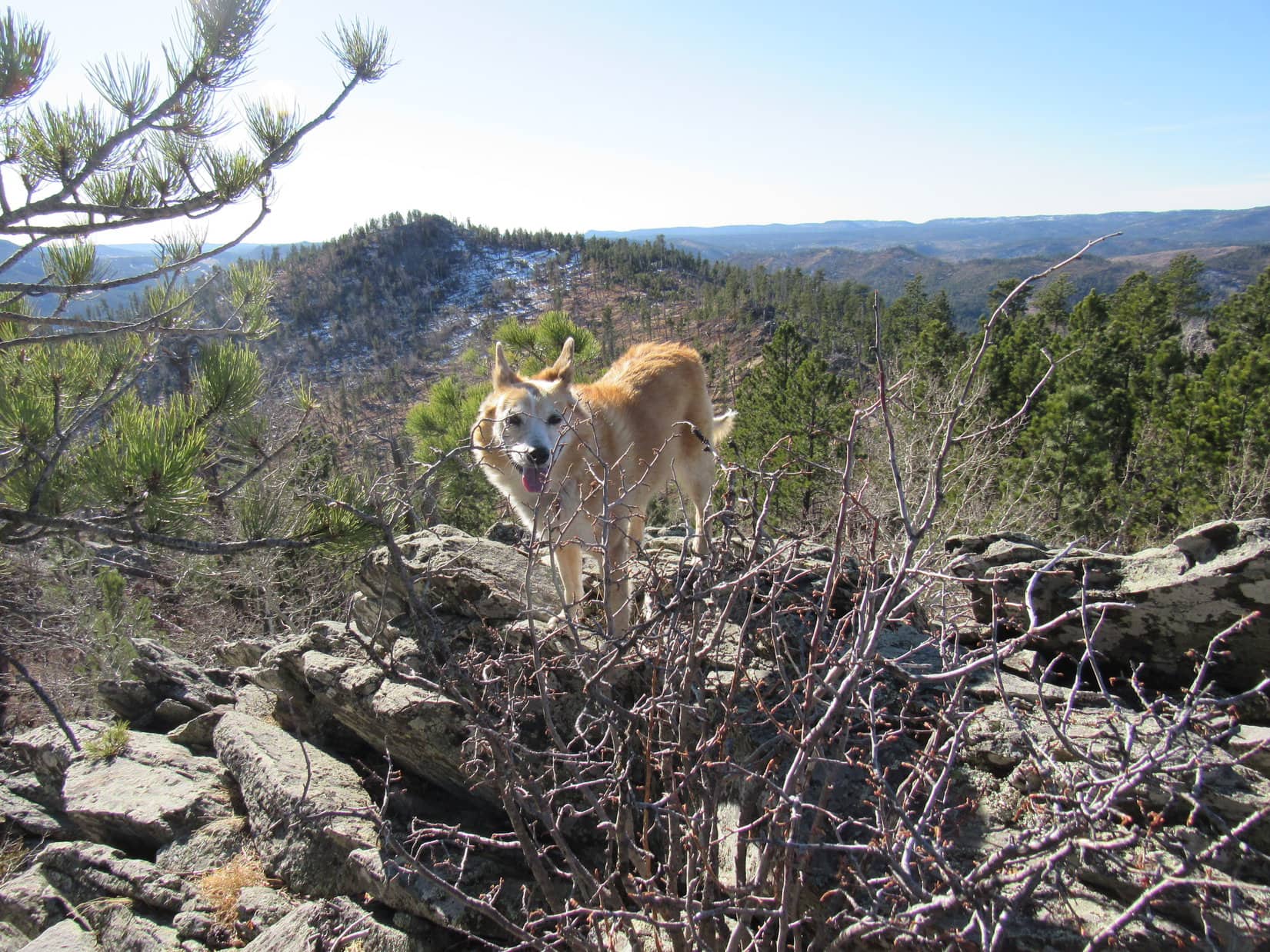
Most of the time the going was easiest E of the ridgeline.  The deadfall didn’t get bad until Looper was halfway to HP6583.  With so many trees down, Loop enjoyed a sweeping view of Elkhorn Mountain (6,381 ft.), Black Elk Peak (7,231 ft.), Peak 6920 and others off to the E and SE.

Leaving the true summit region. Photo looks SE.
Elkhorn Mountain (L), Black Elk Peak (Center), Peak 6920 (next knob to the R). Photo looks SE.
A glance back at the true summit (L). Photo looks S.

Shortly before reaching HP6583, most of the deadfall ended.  Lupe passed through a short section of young pine forest which led to a small boulder field next to a big rock formation at the top.  Circling around the NW side, the Carolina Dog scrambled up from the NE.  A lone pine tree’s inopportunely situated branches made following Loop a little tricky, but SPHP soon joined her on top.

Not much room up here, either, but definitely more comfortable than Zimmer Ridge’s true summit had been.  A U-shaped rock formation open to the SE surrounded a small area where Lupe could relax on a bed of pine needles, if she wanted to.  SPHP tossed some prickly pine cones out of it for her.

Loop on the rock formation at the top of HP6583. Photo looks SW.

The views from HP6583 were quite similar to what they’d been over at the true summit.  Loopster and SPHP hung around for half an hour.  A couple of little chocolate coconut bars were shared.  Lupe also partook of some Taste of the Wild while SPHP munched the usual apple.

True summit of Zimmer Ridge (L) from HP6583. Photo looks SW.
Another angle. Photo looks SSW.
Peak 6600 is the high point on the next ridge past Loop’s head. Photo looks W.

Mighty nice day for late November!  Time passed quickly.  Before all was over and done with, Lupe had also visited a lower rock formation off to the NE which had a view of Five Points (6,221 ft.).

Five Points (L of Center) from the lower NE rock formation. Photo looks NE.

Peak 6600 on the W side of Whitehorse Gulch was the American Dingo’s final peakbagging objective for the day.  Abandoning Zimmer Ridge, Lupe started down HP6583‘s NW slope.  This was all densely forested, fairly steep territory.  For a while boulder fields were off to the L (S) as Loop worked her way W.  Some deadfall, but not bad.  No views except trees, a mix of aspens and pines.

Descending Zimmer Ridge. Photo looks WSW.

Looking for a minor hill on the way to Pass 5935, Lupe finally saw it a little off to the NW.  She headed over toward it, but turned W along the S slope instead of going all the way to the top.  Upon reaching the Pass 5935 region, Loop came to a clearing.  Nearby was a dirt road which she followed NW up to a junction with USFS Road No. 387.1B.

Looper reaches USFS Road No. 387.1B near Pass 5935. Photo looks WSW.

Taking No. 387.1B, Lupe followed it up a short rise.  Once it topped out, the road then headed SW down a ravine leading into Whitehorse Gulch.  At the bottom, No. 387.1B turned NW.  Before making the turn, Loop left the road at the bend, heading down to a little pond only 200 feet away.

This pond had been a pretty spot the last time the Carolina Dog had been here more than 6 years ago.  Today it was frozen over, and seemed sad.  Everything looked motionless and dead.  A moment of silent reflection, and Lupe returned to the road, now going NW farther up Whitehorse Gulch.

Nearing the bend in Whitehorse Gulch. Photo looks WSW.
By the frozen pond. Photo looks SW.

For about a mile, No. 387.1B wound its way steadily higher.  Lupe came to a new, unmarked dirt road that angled off to the L, but didn’t take it.  After a while, the air became more strongly pine-scented than usual.  The reason was soon clear.  Logging!  The forest that had been here ever since Lupe had last been this way was now mostly gone.

The loggers had been here just recently.  Lupe passed numerous stacks of fresh cut logs, and huge piles of branches still loaded with green pine needles.  The change opened up the valley view, but the freshly churned up ground wasn’t pretty, the damage too new.

Lupe was undeterred, still happily exploring ahead, but SPHP trudged after her in an increasingly melancholy mood.

Exploring upper Whitehorse Gulch. USFS Road No. 387.1B (R). Where the new dirt road on the L goes remains a mystery. Photo looks NNW.
Whitehorse Gulch. Photo looks NW.
Near the start of the recently logged region. Photo looks NNW.

At the extreme N end of Whitehorse Gulch, No. 387.1B came to an end at a circular turnaround loop.  A more primitive road went W from here, and soon climbed a short steep slope.  Up on top, now 0.75 mile due N of Peak 6600, Lupe found she had reached a minor pass.  A fence crossed the road, but the gate was open.  Beyond the fence was a meadow and views of nearby hills to the NW.

Leaving the road, the Carolina Dog headed S along a broad ridge leading to Peak 6600.  Loggers had been up here, too.  All large trees were gone, although small ones remained, the ground churned up with caterpillar tracks and littered with little broken branches still sporting bright green pine needles.  Zimmer Ridge (6,600 ft.) could be seen off to the ESE, the top of Black Elk Peak poking up behind it.

Zimmer Ridge (Center). Photo looks ESE.

The loggers hadn’t made it all the way to Peak 6600 along this ridge, but they’d gotten fairly close.  Lupe had to duck under the annoying ancient barbed-wire fence that also went this way a couple of times, but finally got past it, too.

Closing in on Peak 6600 (R). Sylvan Hill (L) in the distance. Photo looks S.

Little patches of snow were still slowly melting on the N slopes, as Lupe made the final 200 foot ascent to the top of Peak 6600.  Not particularly steep, just a forested, and in a few spots, snowy trek higher.

Peak 6600 has two summits, E and W, separated by 300 feet.  Coming up the NNE slope of the mountain, Looper reached the E summit first.  She scrambled up onto a narrow, vertical band of rock running N/S at the high point.  This was the same spot she had reached 6 years ago, where SPHP had taken a photo of her silhouetted as the sun sank in the W.

Not that late in the day yet this time around.  SPHP took a couple of new photos of Loop on the E summit, but from different angles than before.

Peak 6600, at the E summit. Photo looks S.
E summit from another angle. Photo looks NW.

Trees interfered with the views.  The W summit was a bit higher in SPHP’s opinion, although it couldn’t be seen clearly from here for the same reason.  Lots of deadfall between the two summits.  Lupe stayed near the N edge, trying to avoid the mess as much as possible, as she headed over to the true summit.

3:17 PM – Lupe stood poised at the true summit of Peak 6600 enjoying a sunlit reception.  45 minutes before sunset.  She would spend 25 of them right here.  This was a beautiful spot, with some room to move around.  The best and only open views were off to the N and W where a series of forested hills led to the high ridges of the limestone plateau country.

In brilliant sunshine at the true (W) summit of Peak 6600. Photo looks N.
Limestone plateau ridges on the horizon (L). Photo looks WNW.
Bear Mountain (7,166 ft.) beyond Lupe. Photo looks WSW.
At the S end of Peak 6600’s W summit region. Photo looks S.

The last apple vanished.  Lupe had more Taste of the Wild.  Water for all.  Conditions were awesome for late November, and the slanting rays of early evening sunlight made everything so beautiful!  Wouldn’t last.  Looper cooperated fully in getting a few more dazzling Dingo shots.

Green Mountain (7,164) (L) in the distance. Photo looks NW.
Evening on Peak 6600. Photo looks W.
Back on the highest rocks of the true summit. Photo looks N.

Would have been fun to stay and watch the sunset, but it was a long way back.  The most direct route would be steep and full of deadfall.  Better to leave early enough to not get stuck out among the worst of it in the dark.

Prudence was going to win out.  The sun wasn’t quite low enough yet to get a true silhouette shot this time, but SPHP tried anyway, hoping to get a couple that might be close before Lupe left Peak 6600 again.  This time she stood proudly atop the true (W) summit, instead of the E one.

Peak 6600, true summit. Photo looks W.
Final moments atop Peak 6600.

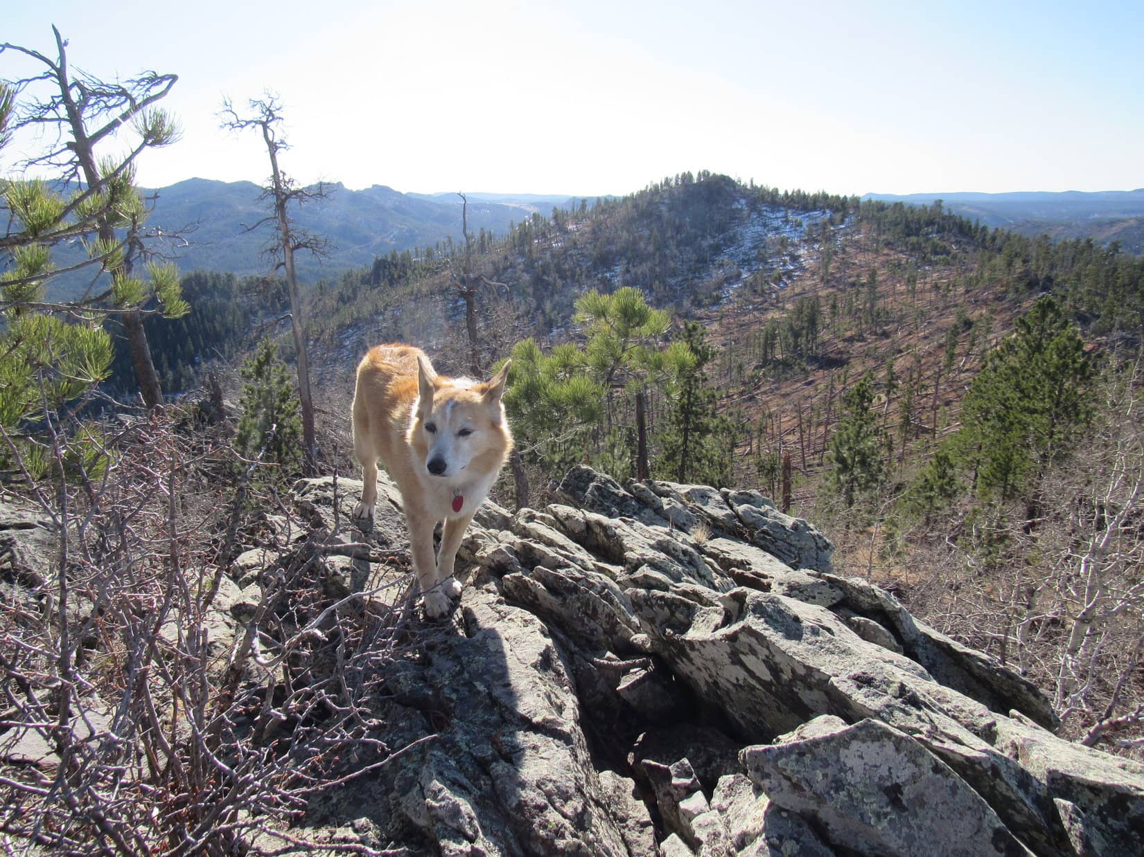
And the race was on!  The American Dingo started down Peak 6600’s steep SE slope, dodging all the deadfall as best she could.  She’d barely gotten going, when the views of Zimmer Ridge and the rugged territory surrounding Black Elk Peak were worth a pause.

Zimmer Ridge (Center). Photo looks E.
Black Elk Peak (L), Peak 6920 (Center), and Little Devils Tower (R). The SW ridge of Zimmer Ridge, which Lupe had climbed this morning, is the foreground. Photo looks ESE with help from the telephoto lens.

Dusk in Whitehorse Gulch.  The night sky never did get all that dark.  The white ghost of a nearly full moon rose over the shoulder of Zimmer Ridge.  Skirting fences along the edge of private property, an American Dingo slunk undetected through shadowy forest.

Chilly out again, but homeward bound.  (5:50 PM, 24ºF)

Peak 6600, Black Hills of South Dakota, 11-28-20

Links:

Next Black Hills Expedition                 Prior Black Hills Expedition

Black Hills, SD Expedition No. 101 – Zimmer Ridge & Peak 6600 (10-23-14)

Want more Lupe adventures?  Check out Lupe’s Black Hills, SD & WY Expeditions Adventure Index, Master Adventure Index, or subscribe free to new Lupe adventures!

Kings Peak, Uinta Range, the Utah State High Point – Part 2: To Gunsight Pass & the Summit! (7-24-20)

Days 15 & 16 of Lupe’s 2nd Summer of 2020 Dingo Vacation to Wyoming & Utah!

7-24-20, 6:50 AM, Henrys Fork trail No. 117, 0.5 mile S of Dollar Lake – Getting off to a reasonably early start, Henrys Fork trail No. 117 was empty as Lupe reached it.  Heading S, she could soon see Gunsight Pass, her first objective of the day, over 1.5 miles to the SE.  Although the pass was nearly 1,000 feet higher than where Loop was now, it sure didn’t look like it from here.

10 minutes after reaching the trail, Lupe came to a junction.  A sign said the path to the R went to Henrys Fork Lake.  No need to go there.  The Carolina Dog stuck with No. 117, which was already making a beeline for Gunsight Pass.  Lupe’s early start had barely beaten others to the punch.  Looking back, several groups of hikers were already hot on SPHP’s heels.

Heading for Gunsight Pass (Center). Gunsight Peak (13,263 ft.) (L)) and Dome Peak (13,103 ft.) (R). Photo looks SE.
Sign at the junction with trail No. 116 to Henrys Fork Lake.

Although she had been steadily gaining elevation nearly the whole way, as Loopster drew close to Gunsight Pass, actually getting up there was looking more difficult.  Apparently, she was still facing a rather steep rocky climb of several hundred feet.

Approaching Gunsight Pass. Hikers were already passing SPHP. Photo looks SE.

However, this proved not to be the case.  At the base of the steepest part, instead of proceeding right on up, the trail swung sharply NW along the rocky slope to the R (SW).  A steady, easy pace higher eventually brought Lupe to a second sharp corner where the trail turned SE again.  In the end, this one enormous switchback easily got the American Dingo up to a giant cairn astride Gunsight Pass.

At Gunsight Pass. Photo looks SSE.
Looking NW back into Henrys Fork Basin, where Lupe had just come from. Trail visible on the slope to the L.

From Gunsight Pass, Lupe could see Painter Basin, a vast lower region of grasslands, streams, bushes and small lakes to the SE.  In the distance, forests were visible near the ridge along the S edge of Painter Basin that culminated toward the E in Val Benchmark Peak (12,516 ft.), which looked like an easy climb if Loop had been headed that way.

Beyond the W end of the Val Benchmark Peak ridge, the Carolina Dog also had a decent view of Mount Emmons (13,440 ft.), 4th highest peak in Utah.  Even Mount Emmons appeared to be little more than a huge rounded hill, another easily climbed peak if approached from the proper direction.  The cliffy N face oriented toward Gunsight Pass, though, would clearly be another matter entirely.

Painter Basin from Gunsight Pass. Val Benchmark Peak (L). Mount Emmons (R – straight up from Lupe). Photo looks SE.

Officially, Henrys Fork trail No. 117 ended right here at Gunsight Pass, but in reality continued SE as Trail No. 68 into Painter Basin, where it would eventually link up with No. 25 going W up to Anderson Pass.  Less than a mile N of Kings Peak, Anderson Pass was the American Dingo’s next objective, but she did not take Trail No. 68 down into Painter Basin.

A steady stream of hikers also destined for Kings Peak was now coming up to Gunsight Pass from Henrys Fork trail No. 117, just like Loopster had, but none of them were proceeding down into Painter Basin, either.  Instead, everyone was veering R (S) toward a steep band of rocks along the lower E face of Dome Peak (13,103 ft.).  A relatively short, successful scramble on this route would make it possible to knock a good 2+ miles off the trek to Anderson Pass, saving an extra 600 feet of both elevation loss and gain in the process.

If everyone else could manage to get up that steep rock band, even SPHP might stand a chance, too!  Once satisfied with her inspection of Painter Basin from Gunsight Pass, Lupe joined the procession heading S along the use trail.

Trail No. 68 (visible at L) heads down into Painter Basin, but a use trail shortcut goes up the ridge seen straight ahead. Photo looks SSW.
Loop by the use trail, joining everyone else that would rather risk their necks than hike an extra couple of miles. Photo looks SSW.

Nothing to the first part of the use trail, not until it got clear over to the base of the steep, semi-cliffy, band of rock.  There, the situation suddenly became a lot more interesting.

SPHP kept a good eye on where everyone else was starting up.  It soon turned out that the use trail was somewhat braided.  Sort of a choose or make your own use trail kind of thing.  Lupe led the way higher, fully confident of her abilities to scramble up most anywhere, while SPHP tried to stick with the most popular and least exposed routes.

Following others near the start of the steep part. Photo looks SSW.
Eh, nothing to it!

A little sketchy in places, but not too bad!  Everyone was making it.  No one turned back.  Soon Lupe was through the worst of it, up on a grassy slope that wasn’t quite as steep.  The terrain got easier and easier as she began angling SW while following a series of cairns toward Dome Peak’s lower SE ridge.  As Loop got close to the ridgeline, the long, steep rocky slope of Kings Peak’s E face came into sight.

Made it! Looking NNE back down on Gunsight Pass (Center).
Following cairns toward Dome Peak’s lower SE ridge. Photo looks SW.
The E face of Kings Peak (L) comes into view. Photo looks SW.

The ridge turned out to be rounded and indistinct, but once sufficiently along it, the valley leading to Anderson Pass could be seen ahead.  This valley looked like an easy trek, but proved to be extremely rocky.  Lupe bounded along effortlessly, but crossing the pathetically simple-looking valley and getting up to Anderson Pass took SPHP 70 minutes.  As usual, others, being part mountain goat, managed it much more quickly.

Anderson Pass (L of Center) ahead! N ridge of Kings Peak (L), HP12880 (R of Center), Henrys Fork Peak (13,240 ft.) (R). Photo looks W.
Approaching Anderson Pass (R). N ridge of Kings Peak (L). Photo looks SW.

7-24-20, 10:23 AM, Anderson Pass – Getting to Anderson Pass marked the end of the preliminaries, and was an accomplishment of sorts in its own right.  From here, all that remained was the 0.75 mile scramble up the N ridge of Kings Peak (13,528 ft.).  The summit region was already in view.  South Kings Peak (13,512 ft.), Utah’s 2nd highest a mere 0.75 mile farther S along the same ridge, was in sight, too.

Loopster at Anderson Pass. Kings Peak (L) and South Kings Peak (R). Photo looks S.

Lupe enjoyed other interesting sights from Anderson Pass.  To the SW she could now see the Yellowstone Creek Basin.  The ridge leading W to Henrys Fork Peak (13,240 ft.) had an intimidating knife-edge look to it, putting a quick end to any goofy thoughts of taking that beast on.  To the NE, Dome Peak (13,103 ft.) and more distant Gilbert Peak (13,442 ft.), 3rd highest in Utah, both appeared far more feasible.

Yellowstone Creek Basin from Anderson Pass. Photo looks SW.
Gilbert Peak (Center) and Dome Peak (R). Photo looks NE.

A 15 minute breather at Anderson Pass, and that was it!  Looper started up the long rocky N ridge of Kings Peak.

Underway again. Despite appearances, the summit is way over at far R. Photo looks SE.

Talus, moderate-sized, but talus nonetheless.  SPHP is terrible on talus.  Many loose or tippy rocks.  The sure-pawed American Dingo had no problem at all.  She ended up with all kinds of time to enjoy the views while SPHP crept higher, spending it gazing this way and that.  At first, some decent use trails were present, but they soon became intermittent at best.

The W side of the ridge was scary steep, often presenting sheer cliffs.  Looper, like everyone else, stayed mostly E of the ridgeline, although at times she was right up on it.  Every now and then the top of the ridge provided short level stretches where even SPHP made rapid progress.

Right up along the cliffy W edge of the N ridge. Kings Peak (L) and South Kings Peak (R). Photo looks S.
A little E of the ridgeline in sort of a nice stair step region. Photo looks S.
At a flat spot right up on the ridgeline. South Kings Peak (R). Photo looks S.

A beautiful day in July climbing the highest peak in Utah!  The N ridge of Kings Peak had become a very busy place.  Groups of hikers streamed by.  Even a guy with a prosthetic leg passed SPHP up.  Ridiculously agile people were already on their way back down!  Lupe was kind enough not to complain about SPHP’s torpid pace.  She was getting there, bit by bit, passing one false summit after another.

Getting pretty high, but that’s still not the summit yet directly ahead.
On the only patch of snow Loop came to on the way up. Val Benchmark Peak (L) in the foreground. Albert Lake and part of larger Atwood Lake (R of Center). Photo looks SE.
A use trail reappears not too far from the top.

100 people must have beaten SPHP up the mountain.  Well, something like that.  It was a bunch!  No big deal, but by the time the true summit came into view, Lupe’s beautiful July day had come and gone, too.  Gray clouds were sweeping in out of the W.  It started to snow.

Approaching the true summit. Photo looks S.

Lupe reached the top of Kings Peak (13,528 ft.) amid a mini-blizzard of snow granules like tiny hailstones.  Hardly anyone was still at the top of the mountain, except a family of 3 who had arrived shortly before Lupe got there.  The wife and daughter were leaping into the air as husband-dad took photos.

Just a summertime squall.  The mini-blizzard soon passed off to the E.  A series of similar squalls were still on the way, but the next one wouldn’t hit for a while.  Once the family was done with their photo shoot, Looper took her turn by the summit cairn.

On Kings Peak, Utah, only Lupe’s 4th state high point. Photo looks W.
Another squall on the way. South Kings Peak (L). Photo looks SW.

The family of 3 left, but the Carolina Dog was seldom alone.  Stragglers continued to come and go, although it was clear that the big rush was now over for the day.  Lupe and SPHP remained in the summit region, hanging out while the next squall took aim at Kings Peak.

The views were grand in all directions unobscured by the snow squalls.  Not far to the N, some of the most dramatic scenes were provided by cliffs Lupe had passed by on the way up.  In the opposite direction, the ridge leading SSW to South Kings Peak (13,512 ft.) looked less daunting, although still nothing but rock the entire way.

Dome Peak (R – straight up from Lupe’s head). Gunsight Peak and Gilbert Peak (both lined up far R). Photo looks N.
Cliffs along the N ridge. Photo looks N.
Another look. HP12880 (Center) along the next ridge. Photo looks NNW.
Checking out the ridge leading to South Kings Peak (R). Photo looks SSW.

Mount Emmons (13,440 ft.) to the SE, and Tokewanna Peak (13,165 ft.) to the WNW stood out amid many other peaks of the Uinta Range.

Tokewanna Peak (R) in the distance. Photo looks W.
Mount Emmons (Center). Photo looks SE.

SPHP had hoped Lupe would get to spend an hour on Kings Peak, but 40 minutes after she arrived the next squall hit.  Thunder rumbled several times, a clear warning!  Reluctantly starting down the N ridge as it began snowing again, the tip of SPHP’s L hiking pole sizzled and buzzed when held aloft.  Somewhat concerning!  Soon snow granules were pelting Kings Peak so hard that Loop and SPHP sought partial shelter under an overhanging rock.

The American Dingo turned white.  Amazingly, even the ground way down in Painter Basin was turning white, but winter in July only lasted 10 or 15 minutes before easing up.  Lupe resumed her scenic trek down the N ridge as the squall moved E, SPHP trudging slowly and carefully along behind.  Sunshine reappeared, melting the snow almost instantly, leaving the talus slick and wet.

Heading down. Henrys Fork Peak (far L), Henrys Fork Basin (Center), Dome Peak (far R). Photo looks N.
Loopster in sunlight back at the big snowbank as the second snow squall moves away. Val Benchmark Peak (L), Mount Emmons (R). Photo looks SE.

A third squall line took aim at Kings Peak, but ended up missing to the S.  Conditions improved.  Although clouds were always around, for a while the day grew sunnier.  More hikers appeared, still on their way up the mountain.  By the time Lupe made it back to Anderson Pass, those tight new boots were beginning to bother SPHP’s paws again.

Yep.  Sadly, yesterday’s grand hopes of tackling other peaks in the region were mere delusions.  Kings Peak had been enough!

Continuing down the N ridge. Henrys Fork Peak (L). Photo looks NW.

From Anderson Pass, this time Lupe followed Trail No. 25 SE for 0.5 mile before turning NE toward Dome Peak’s SE ridge.  The trickiest part of the entire day’s scrambling was the down climb through the very steep rock band that had to be negotiated on the way back to Gunsight Pass.

Near Painter Basin (L) again. Mount Emmons (L of Center). Photo looks SSE.
Approaching Gunsight Pass again. Photo looks N.

The sun was getting low as Lupe headed down the long switchback from Gunsight Pass back into Henrys Fork Basin.  How long does it take to break in a new pair of boots anyway?  These were the worst ever, simply too tight, rubbing paws raw by the end of any long day!  SPHP hobbled along taking every step gingerly.

Seemed like a long way back.  The American Dingo was still undaunted, though!  Lupe continued roaming ahead, coming back every so often to check on Gimpy.  The evening light was awesome, the clouds moody and shifty – now pure and brilliant, now sullenly brooding.

On the way back to the tiny house.

The glorious day Lupe stood on Kings Peak (13,528 ft.), tippy top of Utah, came to an end as the Carolina Dog reached her tiny house 0.25 mile S of Dollar Lake.  A couple of campfires were blazing off to the N while the sun slid below the giant ridge W of Henrys Fork Basin.  Ahh, Utah!  How long had it been since Lupe had last spent any time here?  Years and years.  Way too long.

7-25-20, noonish –  The tiny house was all packed up.  Everything was.  Unenthusiastically, SPHP hoisted the whole heavy load, strapping it on.

Alright, sweet puppy!  This is it!  You ready?

No mountains today, SPHP?

Nope, sorry!  I’m better, but not good enough to tackle anything else.

Too bad.  Gunsight and Gilbert didn’t look that hard, and we’re already right here in perfect position!

I know it.  It’s a crying shame, but I gotta let these paws get a better rest, and we don’t have enough supplies to stay out here for days on end.  Maybe it’s not such a tragedy, though?  We need to get back pretty soon anyway to find out what the news is.  If Canada and Alaska are opening up, we’ve got lots to do to get ready.  The Most High Exalted Dingo of the Arctic Sisterhood wouldn’t want to miss out on that, would she?

No, of course not, SPHP, but do you really think it’s going to happen?  This has been such a strange year.

Good chance it won’t happen, Looper.  Maybe, though.  We’ll know soon enough.  If not, we’ve got a date with our buddy, Jobe!  In Montana!

So the adventure continues, then!

Oh, of course it does!  Wouldn’t have it any other way would we?  Onward!  Puppy, ho!

Curly tail held high, Lupe set off across the grassy plain where the tiny house had been toward the trees where she would pick up Henrys Fork trail No. 117.  Magnificent Kings Peak and the fabulous Uinta Range now receding behind her, the plucky Carolina Dog didn’t even look back.  Her second Dingo Vacation of the Year of Perfect Vision was about over; only the long road home remained.  (End, 7-26-20, 2:57 AM)

Kings Peak, Uinta Range, the Utah State High Point, 7-24-20

Links:

Next Adventure                          Prior Adventure

Kings Peak, Uinta Range, the Utah State High Point – Part 1: Henrys Fork Trailhead to Dollar Lake & Beyond!

Want more Lupe adventures?  Choose from Lupe’s Summer of 2020 Dingo Vacations to Wyoming, Utah & Montana Adventure IndexDingo Vacations Adventure Index or Master Adventure Index.  Or subscribe free to new Lupe adventures.