Black Hills, SD Expedition No. 189 – Peak 5778 & Peak 5834 (1-30-17)

9:49 AM, 44°F, junction of Lower French Creek Road & USFS Road No. 341 –  More snow than SPHP expected.  Although lots of snow had finally started melting back home, not much appeared to have melted here.  Either that, or this part of the Black Hills had received considerably more new snow out of the last little storm.

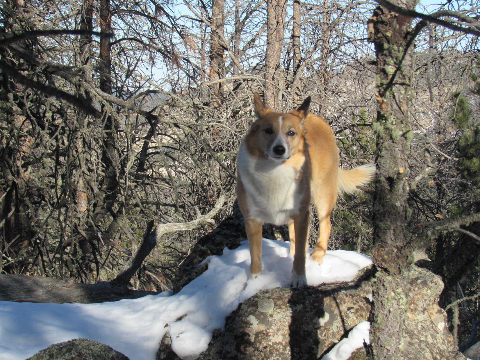
Whatever.  Lupe didn’t care.  She was just happy to be doing something again.  January had been a tough month on the American Dingo.  Way too much time had been spent staring out the window at the cold, barren winter landscape.  This was only her 2nd Black Hills, SD expedition of 2017.  By this time in 2016, she’d been on 5.  Lupe was raring to go!

The Carolina Dog was here to continue her explorations of the southern Black Hills peaks Brian Kalet had added to the Peakbagger.com data base last spring.  Her first objective was Peak 5778, located 0.33 mile SE of Stockade Lake, and 1 mile due E of where Lupe was starting out from.  She crossed over to the E side of Lower French Creek Road, and headed ENE into the snowy forest.

A gradual climb ended on a forested ridge where Lupe had a nice view to the N.  She could also see part of Stockade Lake.

A gradual climb through the snowy forest led to this small ridge with a view to the N. On the L from L to R are Little Devil’s Tower (6,960 ft.), Cathedral Spires (6,840 ft.), and Black Elk Peak (7,231 ft.). The middle peak on the R is Peak 6735  . Photo looks N.
Loopster looking quite happy about finally being out in the Black Hills again on Expedition No. 189. Part of frozen Stockade Lake is seen beyond her. Photo looks ENE.

From this first viewpoint, Lupe turned E, following the ridgeline down through the forest.  She hadn’t gone too far before the road leading to the Stockade Lake dam came into view below.  Lupe went N down a short, snowy slope to the road.

Here in the shade, the road was snow-packed and slippery, but it soon led Lupe E to sunshine at Stockade Lake.  Peak 5778 was now in view dead ahead.

Lupe reaches the Stockade Lake dam. The spillway is on the other side of the road at the far end. Peak 5778 is in view on the R. Lupe planned to climb it going up the long N slope from the L. Photo looks E.

Before crossing the bridge over French Creek, Lupe left the road to take a quick look at French Creek below the spillway.  The stream was mostly iced over, but part of it was open and free flowing.  A little downstream of the bridge, it went over another drop where a small waterfall was bordered on each side by ice formations.

Ice on part of the Stockade Lake spillway is seen beyond the bridge over French Creek. Photo looks ENE.
French Creek just below Stockade Lake. Photo looks ENE.

After checking out French Creek, Lupe returned to the road, crossed the bridge, and continued on around the SE end of Stockade Lake.  From a deserted picnic ground along the S shore, Lupe had a view of the biggest part of Stockade Lake.  Some of the highest and roughest ground in the Black Hills could be seen beyond the lake in the distance.

Stockade Lake from the SSE shore. Photo looks NNW.
Little Devil’s Tower is the dome of rock on the L. The jagged rocks to the R of it are the Cathedral Spires. Black Elk Peak is the highest point on the R. The wall of rock just to the L of Black Elk is Peak 6920. Photo looks NNW using the telephoto lens.

Lupe continued on around the SE shore of Stockade Lake until she was almost even with the far E end of the lake.  She then left the road to scramble up a bank to the E which brought her to the top of a small ridge.  Upon reaching the ridgeline, Lupe was excited to see a few deer.  The deer ran off, but Lupe found a squirrel tree, too, another encouraging development!

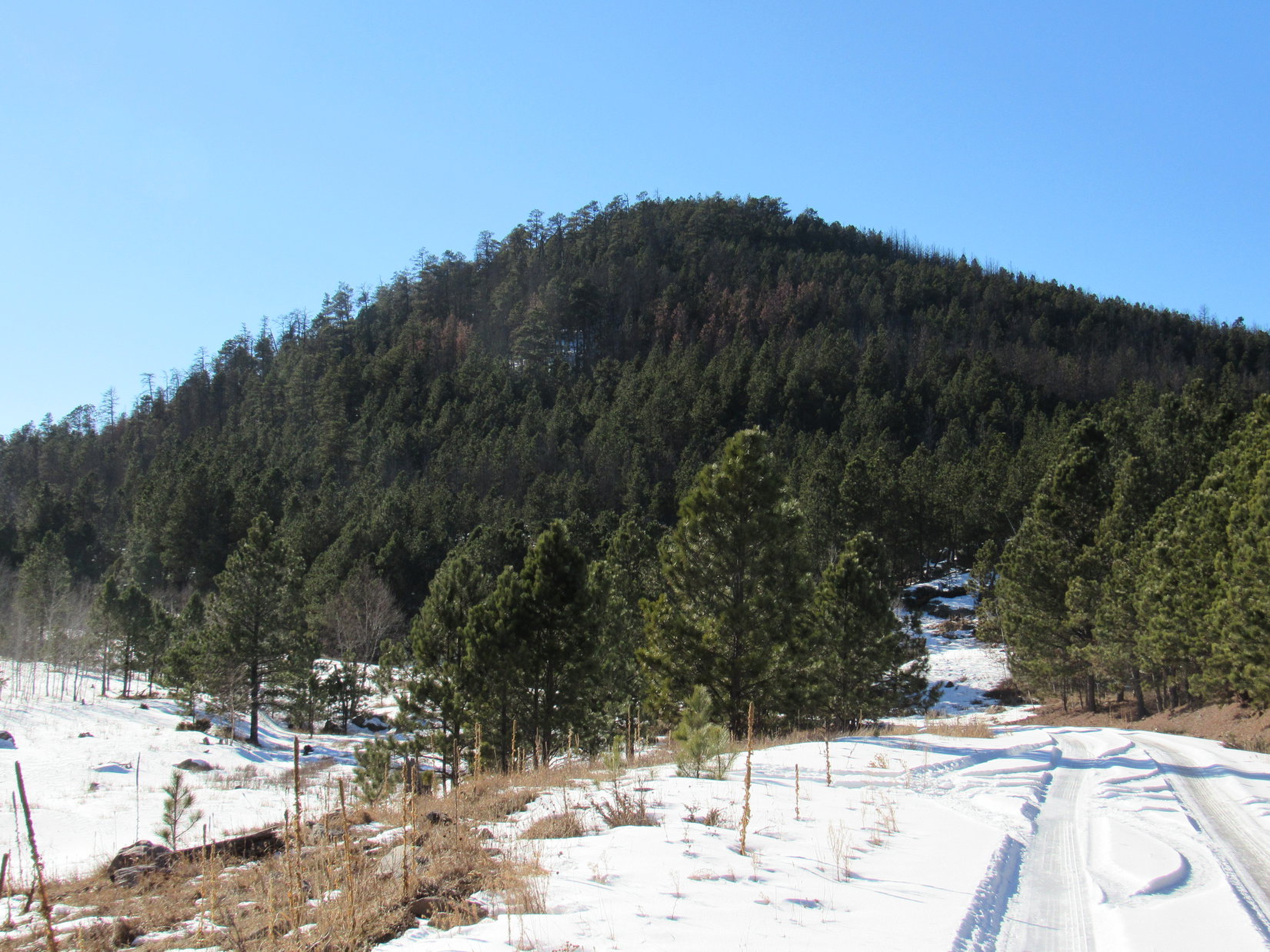
Lupe was now directly NW of Peak 5778.  It was time to begin her journey up the NW slope.  The minor ridgeline she was on slowly faded, blending into the rest of the slope.  The terrain gradually became steeper as Lupe climbed.  The forest in this area had been thinned by logging operations.  Lupe had some tree-broken views, but no clear views.

The climb was steady, but only moderately steep.  A good 6″ of snow covered the entire slope most of the way up.  The snow, and a fair amount of slash left behind by the logging operations, were the only obstacles.  The route up wasn’t very rocky.  Lupe had an easy time, but somehow the climb seemed tougher to SPHP than it should have been.  All that sitting around during the holidays and cold weather in December and January hadn’t done SPHP any good, either.

After a steady slog up the snowy slope, Lupe was finally getting close to the summit.  The ground started leveling out.  Lupe encountered much less snow up here, but many more rocks.

Lupe near the top of the NW slope of Peak 5778. She’s coming back down to see what’s keeping SPHP. Deconditioning from inactivity during the holidays and two months of cold weather were SPHP’s lame excuse. Photo looks SE.

At the top of Peak 5778, Lupe reached a narrow summit ridge oriented NW/SE.  It wasn’t very long, maybe 40 or 50 feet.  Lupe found the highest rocks of the true summit near the SE end.  SPHP congratulated Lupe on her successful ascent of another Brian Kalet peak!

Lupe reaches the true summit of Peak 5778. Photo looks SE.
Looper looking good on Peak 5778. Another successful ascent of a Brian Kalet peak!

The forest on much of the NW slope of Peak 5778 had been thinned by loggers, but the logging operations hadn’t extended to the upper part of the mountain.  The summit ridge was still heavily forested.  Although glimpses of nearby mountains could be seen between the trees, the only even partially clear view from the top of Peak 5778 was toward Custer Mountain (6,089 ft.) to the WSW.

Lupe had been on top of Custer Mountain only 12 days ago near the end of Black Hills, SD Expedition No. 188.

The only even partially clear view Lupe had from Peak 5778 was toward Custer Mountain (6,089 ft.) to the WSW. Lupe had been on top of Custer Mountain only 12 days ago near the end of Black Hills, SD Expedition No. 188.
The forest had not been thinned on top of Peak 5778. Here, Lupe is on the summit ridge with a typical “view”. Photo looks NNW from the true summit.

It hadn’t taken Lupe long to climb Peak 5778.  With no views to ponder, there wasn’t much reason to stick around and take a break this early in the day.  Lupe and SPHP stayed only 10-15 minutes up on Peak 5778 before starting down again.

Lupe explored a different route on the way down the mountain.  She followed a ridge going WSW.  This was actually a more interesting route than the NW slope had been.  The Carolina Dog discovered a series of rock outcroppings in the forest along the way.  Before losing much elevation, Lupe found a fairly decent viewpoint.

From one of the rock outcroppings, Lupe could see several peaks she had been to before.  Kruger Peak (5,838 ft.) and Daisy Peak (5,948 ft.) were both lined up directly in front of higher and more distant Northeast Cicero Peak (6,240 ft.).

Kruger, Daisy and Northeast Cicero Peaks are all lined up L of Center, with NE Cicero Peak being the distant high point. Lupe has been to all 3 of those peaks a couple of times on earlier Black Hills expeditions. Expedition No. 189’s next peakbagging goal is also in view here as the small, darkly forested hill seen on the far R in front of the distant ridge. That hill is Peak 5834. Photo looks SSW.

After losing quite a bit of elevation going down the WSW slope of Peak 5778, Lupe started turning NW.  By the time she reached the base of the mountain, Looper was close to the road near the SE end of Stockade Lake.  Upon reaching the road, Lupe retraced much of her original route back to the G6 (12:28 PM, 48°F).

With the days still being as short as they are in late January, Lupe got a ride in the G6 closer to her next Brian Kalet peak objective, Peak 5834.  S of Custer Mountain, SPHP parked the G6 again along USFS Road No. 337 (Glen Erin Road) about 0.33 mile S of County Road No. 343 (the Hazelrodt Cut-Off).  Lupe was still a couple miles NNE of Peak 5834 (12:43 PM, 48°F).

Lupe followed No. 337 going SSW for 1.5 miles, passing to the W of both Kruger and Daisy Peaks.  The road was snow-packed and quite slippery.  Even Lupe skidded around on some wet, icy spots.  However, there was no traffic at all, and the road was an otherwise easy stroll.  Lupe gained elevation along the way, but very slowly.

Lupe more than a mile S of the G6 on USFS Road No. 337 on her way to Peak 5834. The road was snow-packed and slippery, but a lovely walk with no traffic at all. Photo looks S.

When Lupe was getting close to Peak 5834, she saw a big rock formation of rounded boulders on the W side of No. 337.

As Lupe was getting close to Peak 5834, she came to this big rock formation on the W side of USFS Road No. 337. Photo looks SW.
A closer look at this rock formation NNE of Peak 5834. Photo looks SW using the telephoto lens.

Peak 5834 was soon in view ahead.

After passing by the big rock formation, Peak 5834 came into view ahead. Photo looks SW.

Lupe followed USFS Road No. 337 until she was at the base of Peak 5834.  She wasn’t quite far enough S to be directly E of the summit yet, but left the road here to follow a drainage leading up to the WNW.  She followed this draw almost all of the way up to a saddle N of the mountain.  Nearing the saddle, she turned S to start her climb up the N slope of Peak 5834.

Peak 5834 was densely forested.  Many trees had been killed by pine bark beetles, but there were still plenty of live trees, too.  Once again, there were no views to speak of as Lupe climbed.

For some reason, the snow was even deeper on the N slope of Peak 5834 than it had been on the NW slope of Peak 5778.  For most of the way up, Lupe was having to leap through foot deep snow.  In places, it had drifted even deeper.  As usual, Lupe did fine, though, leading the way while SPHP brought up the rear.  Other than the deeper snow, the climb was pretty similar to Lupe’s trek up Peak 5778.

However, when Lupe reached the summit, she found the top of Peak 5834 was quite different.  The summit area on Peak 5778 had only been a short narrow ridge.  The top of Peak 5834 included a much larger area.  Peak 5834’s summit was shaped like a big boomerang, with the center of the boomerang toward the NW.  Two big arms extended out from the center, one to the E and the other to the SW.  Lupe reached the summit area near the middle of the E arm.

Lupe explored the E arm of the boomerang, but found no clear views.  She then went W toward the high point, perhaps 200 feet away.  This was the true summit of Peak 5834.  It was none too pretty.  Lupe got up on the highest rocks of a small rock formation to claim her latest peakbagging success, but dead pines were all she could see.

Lupe reaches the summit of another Brian Kalet peak, Peak 5834! What a great look at dead pines! Photo looks NE.
Lupe on the true summit of Peak 5834. She first reached the summit area back in the pines seen a little R of Center. Photo looks ENE.

A dead tree trunk extended out to the W from the true summit.  The W end of the dead tree was even a little higher than Peak 5834’s summit.  Lupe readily agreed to strike a dramatic conquering Dingo pose from this lofty dead tree.

The best view from the summit of Peak 5834 was of this mighty American Dingo! Photo looks NNE.

A little to the W of the true summit was another minor high point, but it wasn’t quite as high.  More interesting was a ridge only a few feet high toward the end of the SW arm of the boomerang.  It looked sunnier and more open over there.  Maybe there would be some views and less snow?

Looking SW along the SW arm of the boomerang from a point not too far from the true summit of Peak 5834. Maybe there would be less snow and more of a view over this way?

Lupe went over to the little ridge at the end of the SW arm of the boomerang.  The ridge was very small, just a line of medium-sized rocks really.  However, the SW side of the little ridge was snow-free and dry.  Lupe did have better views from here, too.  Trees still interfered to a significant extent, but Lupe could see a few things.

Lupe reaches the minor ridge at the end of the SW arm of the boomerang. The SW side is snow-free and dry, while the NE side is all snowy. Photo looks WNW.
So, SPHP, how’s this for a Dingo-on-a-dead-tree look? Photo looks NE. Same great Carolina Dog, but I liked the other dead tree better, actually.
Another Dingo-on-a-dead-tree look. Photo looks NW.

With a bit of a view and some nice dry, snow-free ground on the SW side of the little ridge, this was the place to finally take a break.  Before settling down, Lupe posed for a photo of the best view from here, a distant forested ridge off to the SW.  Somewhere in that direction 3 more Brian Kalet peaks were lined up in a row.

Maybe that distant ridge was where those Brian Kalet peaks were?  It seemed quite likely.  If so, Lupe would probably soon be exploring that ridge on Expedition No. 190.  It was fun to think about the adventure to come, and fun to simply relax and enjoy being right here, right now, with Lupe on seldom visited Peak 5834.

The best view from Peak 5834 was from the SW end of the boomerang. Here, Lupe could see a distant ridge of blue hills off to the SW. Somewhere in this general direction are 3 more Brian Kalet peaks Lupe might go see on Expedition No. 190. Maybe Lupe would be exploring that far ridge before long? Photo looks SW.
Lupe could also see Northeast Cicero Peak from the SW end of Peak 5834. There wasn’t a good clear view, but the summit could be seen. This photo looks SSE at the summit using the telephoto lens.

SPHP sat on the ground beside Lupe, while eating an apple.  Lupe was offered some Taste of the Wild, but she wasn’t hungry.  Instead, she sat contentedly basking in the sunshine.

Lupe had plenty of daylight left to get back to the G6, but not enough to tackle any more peaks on Expedition No. 189.  For now, she was happy right here on quiet Peak 5834, staring off toward that distant blue ridge.

Lupe basks contentedly in the sunshine. Photo looks ENE.
It was great being out in the Black Hills again on Peak 5834.

All told, Lupe and SPHP spent 40 minutes or so up on Peak 5834 before it was time to mosey on.  On the way back, Lupe went down the N slope again, but a little farther to the W.  When she reached the saddle to the N, instead of going down the draw to the ESE to the road, Lupe angled NNE staying on higher ground.  Together, Lupe and SPHP explored the snowy forest.

Lupe went quite a distance NNE before she finally lost the rest of the elevation she’d gained, and hit USFS Road No. 337 again.  From then on, it was an easy trot back along the road to the G6 (4:31 PM, 38°F).

It had been a nice day, a beautiful outing.  Lupe had successfully climbed 2 more Brian Kalet peaks.  They weren’t the most spectacular peaks around, but it was still fun to be out and seeing someplace new.

Sometimes that, and being together, is all it’s about.

On USFS Road No. 337 on the way back to the G6 from Peak 5834.

Links:

Next Black Hills Expedition                        Prior Black Hills Expedition

Want more Lupe adventures?  Choose from Lupe’s Black Hills Expeditions Adventure Index or Master Adventure Index.  Or subscribe free to new Lupe Adventures.

Black Hills, SD Expedition No. 188 – Peak 6181, Peak 6040 & Custer Mountain (1-18-17)

2017 was the pits!  Dullsville.  Cold, cold, cold.  And snowy.  Day after day, Lupe stared out the window.  She would heave a big sigh after a while, give up, and go lay on the couch looking like she’d lost her last friend.  Now and then she got to chase her new PupJoy flying disc across the glacier in the back yard, but that was about it for excitement.  With temperatures hovering near zero, she wasn’t even getting her usual evening walks.

However, temperatures had started creeping up the last few days.  The snow began to melt a little.  Finally, this morning’s forecast called for blue skies and unseasonable warmth.  SPHP asked if Lupe would like to go hiking in the mountains?  Lupe could hardly believe her big soft Dingo ears!  If barking, racing around in circles, and leaping for joy mean anything, she was more than ready!

Lupe had spent most of her Black Hills expeditions in 2016 climbing peaks around the SW, NE and NW perimeters of the Black Hills.  In the fall, she even ventured way up into the Bear Lodge mountains in NE Wyoming.  SPHP had expected that by the time 2016 was over, there wouldn’t be many named peaks remaining in the Black Hills that Lupe hadn’t climbed at least once – a handful, but not many.

However, Brian Kalet, a very active mountaineer from Colorado, had come through the Black Hills in May of 2016 to climb a curious set of peaks mostly concentrated in the southern Black Hills.  Brian had added all of them to the Peakbagger.com data base.  When Lupe is logged in to her account, these peaks show up as red circles on the topo map, meaning she hasn’t climbed them.  And Lupe doesn’t allow red circles in her Black Hills home base without a good reason!

Why had Brian come here?  And why had he climbed such an odd combination of mostly unnamed peaks?  The only clue SPHP could find was that all of Brian’s ascents here had over 300 feet of prominence.  Prominence is the vertical distance a peak rises above the highest col (meaning pass, ridge, or saddle) connecting it to a higher summit.

Perhaps Brian had been deliberately searching out mountains with at least 300 feet of prominence?  That’s a metric tracked on Peakbagger.com, and Brian Kalet has climbed over 3,100 different such peaks, the second most of any account holder.  Nothing else seemed to make any sense.

Whatever Brian’s reasons, now that it was 2017, it was time for Lupe to turn those annoying red circles on the map to green.  They had been taunting Lupe long enough!  She’d gotten a head start on the Brian Kalet peaks by climbing Peak 5688 and Peak 5440 in December.  Next up on her list was Peak 6181, located 1.5 miles NW of the town of Custer.

Mica Ridge Road goes very close to Peak 6181, but a quick scouting trip proved the property along the road was all privately owned.  SPHP resorted to parking the G6 at a pullout for an “interpretive site” on the E side of Hwy 385 (9:14 AM, 41°F).  From here, Lupe had USFS land access all the way to Peak 6181.

The mountain was only 1.25 miles off to the SSW.  Lupe crossed over to the W side of Hwy 385, and started climbing a fairly steep slope.  She had to leap through nearly foot deep snow, which easily came up to her belly.  Lupe likes snow, though.  She was excited to be out in the hills again, and having a good time.  Up the thinly forested slope she went, heading for the top of a ridge.  She reached it at a saddle between two minor high points.

The top of the ridge had less snow, only half a foot in most places.  Lupe crossed level ground leading to the nearest high point to the S.  After a short climb, she was there.  Thunderhead Mountain (6,567 ft.), where the Crazy Horse Memorial is located, was in view to the N.  Off to the SW, Lupe could see her objective, Peak 6181.

From the first minor high point Lupe reached, the Crazy Horse Memorial on Thunderhead Mountain was in view. Photo looks N using the telephoto lens.
Off to the SW, Lupe could see her objective, Peak 6181 (Center).

S of the minor high point, Lupe saw a thickly forested hill.  This hill was nearly as high as Peak 6181, but she didn’t need to climb it.  Instead, Lupe went S only far enough to reach a logging road that headed SW.  Near this road was a dramatic looking rock outcropping, the top of which leaned out into space.  It reminded SPHP of a petrified artillery gun, thereby acquiring the name Artillery Rock.

Lupe near the dramatic, overhanging rock outcropping known henceforth as Artillery Rock. Photo looks W.

Snow had drifted onto the logging road as much as 2 feet deep in places, which was pretty deep for Lupe.  Often there was less snow off the road.  Bare ground existed in a few places with a lot of S exposure.  Yet plentiful slash and debris left off-road by the loggers frequently made the road easier to deal with despite the snow.  Lupe continued SW toward Peak 6181 following the road closely, but not always right on it.

Although at times a bit of a struggle for Lupe, the trek along the road was pretty.  The snow was still quite frosty and crunchy.  In many places it was unspoiled by any tracks.  Snow crystals sparkled in the bright sunlight like tiny jewels.  Big granite rock formations nearby added scenic interest.

Lupe on the logging road. Peak 6181 is dead ahead. Photo looks SW.
Snow crystals sparkled like tiny jewels in the bright sunlight.
Getting closer! Granite rock formations near the logging road like those on the R added scenic interest to Lupe’s trek. Photos look SW.

The climb to the top of Peak 6181 was easy, and didn’t take long.  Lupe followed the NE ridge up.  Soon she was standing on the highest rocks at the summit.  Hah, success!  Another red circle on the Peakbagger.com topo map would turn green for Lupe!

Lupe stands on Peak 6181’s highest rocks! Photo looks W.

Lupe had surprisingly good views from Peak 6181.  Most of them were from points a little below the top of the mountain.  Too many trees blocked the views at the summit, although Lupe did have open views toward the W and NW from there.  Atlantic Hill (6,393 ft.) and Bear Mountain (7,166 ft.) were among the peaks she could see from the summit.

Looking NW toward Atlantic Hill and Bear Mountain.
Atlantic Hill is in the foreground slightly L of Center. Bear Mountain is the high, long ridge seen beyond it. Photo looks NW using the telephoto lens.
Looking SW using the telephoto lens.

Even though it hadn’t taken Lupe terribly long to get here, the snow had made the journey considerably more strenuous than it ordinarily would have been.  Lupe and SPHP took a short break at the summit.  Loopster wasn’t hungry yet, but SPHP munched on a few carrot sticks.  Lupe curled up on the ground near SPHP’s feet.

After break time, Lupe went to see the rest of the views from points a little lower down.

Northeast Cicero Peak (6,240 ft.) (Center). Photo looks SE using the telephoto lens.
Harney Peak (7,242 ft.), South Dakota’s highest mountain, was only visible between the trees from one little spot on the NE slope of Peak 6181. Photo looks NE.
Harney Peak using the telephoto lens.
Mount Coolidge (6,023 ft.) is the high point straight up from Lupe’s shoulder. Custer Mountain (6,089 ft.) is straight up from her tail. Photo looks SE.
Sylvan Peak (7,000 ft.) (Center). Photo looks NE.
Buckhorn Mountain (6,330 ft.) (R of Center). Photo looks ENE.

With her exploration of Peak 6181 complete, Lupe returned to the G6 by the same route (11:50 AM, 55°F).  Since it wasn’t even noon yet, Lupe had plenty of time to climb another mountain.  Her next objective was Peak 6040, located a couple miles SW of Custer.

The plan was for Lupe to also climb Custer Mountain (6,089 ft.), if there was enough daylight remaining after Peak 6040.  SPHP parked the G6 at the intersection of Lower French Creek Road and USFS Road No. 341, about 0.75 miles NNE of Custer Mountain (12:06 PM, 54°F).  Lupe set off heading W on No. 341, which was snow-packed.

For a mile, Lupe stayed on No. 341, gaining elevation gradually the whole time.  She then left the road to climb S toward a saddle between High Points 5900 and 5998 on the topo map.  She found a snowy logging road near the saddle, but did not follow it.  Instead, she turned SW toward High Point 5998.  For a while, she had an easy time climbing along a fairly broad, rounded ridgeline.

Lupe had an easy time climbing this fairly broad, rounded ridge on her way to Peak 6040. Photo looks SW.

Lupe tried to bypass High Point 5998, skirting it to the SE.  However, this side of the mountain became progressively steeper, and was littered with increasing amounts of deadfall timber.  Snow made things so slick, that SPHP started slipping.  After a few minor stumbles, SPHP decided Lupe had better head up to the ridgeline.

By now, Lupe was already close to the top of the ridge.  She reached it in only a couple of minutes.  Lupe had succeeded in bypassing High Point 5998 to some degree, but wasn’t far S of the very top.  Only a little farther S was a nice level spot with some grass, and a wide open view toward the town of Custer.

S of High Point 5998 on the way to Peak 6040, Lupe had a great view toward the town of Custer. Peak 6181, which she had climbed earlier, is seen beyond the town a little L of Center. Photo looks NW.

The ridge leading SSW toward Peak 6040 was narrow and rocky.  Peak 6040’s summit was only 0.33 mile away, but this route was very slow going.  Medium-sized rocks sitting at all sorts of angles dominated the whole length of the narrow ridge.  On both sides, the terrain was steep and full of trees, deadfall, and more rocks.  To the E there was also snow.

Lupe on a typical stretch of the narrow, rocky ridge leading SSW to Peak 6040. There weren’t any cliffs or other dangers, but the ridge was full of obstacles that made this route very slow. Photo looks SSW.

Lupe had no choice, but to pick her way forward through all the obstacles, while staying on or very close to the ridgeline.  Gradually, both sides of the ridge kept getting steeper and more difficult.  The rocks on top increased in size as Lupe continued S.  SPHP began to fear Lupe might come to rocks so big she couldn’t climb over or get around them.

The ridge kept getting steeper on both sides, and the rocks on top were getting bigger and harder to climb or maneuver around. Photo looks SSW.

Fortunately, that never happened.  Lupe managed to reach the top of Peak 6040.  The highest rock was only about 50 feet N of the S end of the ridge.  The skinny summit rock was standing on end.  It was barely wide enough for Lupe to balance on, but she hopped right up on it.

Lupe stands on the highest rock of Peak 6040 to claim another peakbagging success! SPHP had started to fear she might not be able to reach the summit from the ridge she had been following. Fortunately, the ridge became a little wider, and the rocks smaller, shortly before Lupe reached the top. Photo looks SSW.

There weren’t any views to speak of from the summit rock due to the forest.  Lupe and SPHP went on to the SSW end of the ridge, where there were at least some views to the S.  Due to the S exposure, the ground was snow-free and dry.  Lupe and SPHP stopped for a break.  Lupe still wasn’t hungry.  SPHP consumed the rest of the carrot sticks.  Lupe curled up with her head resting on SPHP’s leg.

From the end of the ridge, Lupe had a good view of Northeast Cicero Peak. Photo looks S.
Far to the SSW, Lupe could also see Parker Peak (4,848 ft.) (the small hill at Center). Parker Peak is the high point of Fall River County. Photo taken using the telephoto lens.

It had taken much longer to reach Peak 6040 than expected.  SPHP sat looking at the partial views, petting Lupe, and pondering what to do next.  The original idea had been that Lupe would follow the ridgeline all the way back over a series of high points around to Custer Mountain.

Clearly that wasn’t going to work.  The ridge route was too slow.  Lupe would run out of daylight.  Only two other options existed.  She could forget about getting to Custer Mountain today, or she could try going down the SW slope of Peak 6040 to see if there was a faster way lower down leading directly over to the last saddle NW of Custer Mountain.  That was a long shot, but might work.

After a 15 minute break, SPHP checked out that 2nd option.  Peering SW down from the end of the ridge, what little could be seen through the forest was encouraging.  Lupe would easily be able to go down that way, if it didn’t get any steeper.  May as well try it.

Before leaving Peak 6040, Lupe returned to the summit again.

A pensive Lupe sits among rocks a little S of the summit. Photo looks NNE.
Lupe surveys the situation from next to Peak 6040’s summit rock, seen beyond her tail. Photo looks NNE.
OK, I’ve done this mountain, what’s next?
A small opening between branches gave Lupe a glimpse of Harney Peak (R) to the N.
Near the actual summit, Lupe also had this pretty decent view to the SW.

With her photo duties complete, Lupe returned to the SSW end of the summit ridge and started down to the SW.  The forest hid all distant views, but the slope remained only moderately steep the entire way.  Lupe gradually turned S, then SE as the terrain permitted.  This route would have been a much easier way to the top of Peak 6040 than the NNE ridge she had actually followed.

Lupe finally arrived down at the top of an excavation into the side of the mountain.  Below was a flat open area, which might have had something to do with an old mine shown on the topo map.  From the open area, a primitive old road went E.  Lupe went down to the road and followed it.

At first there was a lot of snow, and later on deadfall timber was in the way at regular intervals, but the road was level and turned NNE, the direction Lupe needed to go.  Lupe was making good time again.  Despite a few obstacles, this was a much faster route than the ridge had been.

The road eventually ended, but not until it was almost to a large clearing.  On the opposite NE side of the clearing was the slope leading up to the saddle immediately NW of Custer Mountain.  The sun was low in the sky by the time Lupe gained the saddle, but she still had time enough to climb Custer Mountain!  Up she went.

Lupe had climbed Custer Mountain (6,089 ft.) once before, almost 2 years ago in March, 2015.  SPHP only remembered that the summit had been at some large rocks with virtually no views, but Lupe had found a way to the very top.

Little had changed in nearly 2 years.  After climbing the steep slope, Lupe arrived at the NE end of a narrow summit ridge consisting of large rocks with steep drops on both sides.  However, there was room enough to work SW among the rocks and trees for 100 – 150 feet all the way to the true summit.  Lupe was leery of getting right up on the exposed summit rocks, but finally relented.  The Carolina Dog stood faithfully waiting for the OK to come down.

The only real change at the top of Custer Mountain was that many pine trees had been killed by pine bark beetles and had lost all their needles.  Most of the dead trees were still standing, but it was a little easier than before to see off into the distance.

A slightly nervous Carolina Dog stands at the true summit of Custer Mountain. This was Lupe’s 2nd time here. Photo looks SSW.
Loopster waited up there long enough for SPHP to climb down to take this shot looking back up. Photo looks SSW.
Are you done yet, SPHP? The view is grand if you like dead trees, but I’ve seen enough!

Sunset was coming in 15 minutes.  Time to skedaddle!  SPHP gave the OK, and Lupe jumped down from the true summit.  The American Dingo paused twice going back along the summit ridge, once where there was an opening among the dead trees where she had a good view of Daisy and Kruger Peaks, and again at the very NE end of the ridge, where Harney Peak could be seen.

Daisy Peak (5,948 ft.) (R) and Kruger Peak (5,838 ft.) (L) from Custer Mountain. Photo looks SSE.
Loop at the NE end of the summit ridge. She liked standing on this nice flat rock. Photo looks NNE.
Harney Peak at sunset. Photo looks N.

Back down the steep NNW slope.  The sun was gone before Lupe reached the saddle.  As the light faded, the Carolina Dog turned NNE and continued down the mountain.  The snow was a foot deep in this part of the forest.  Lupe had to work getting through it.  Down, down.  At last USFS Road No. 314 came into view.  Lupe had it made now!  The G6 wasn’t far away.  (5:28 PM, 36°F)

Expedition No. 188 finally got 2017 off to a successful start.  Lupe had fun, and left with high hopes for more Black Hills adventures in the very near future.  After all, she still has a lot of Brian Kalet peaks she needs to climb!

Going down the steep NNW slope of Custer Mountain minutes before sunset.

Links:

Next Black Hills Expedition                   Prior Black Hills Expedition

Want more Lupe adventures?  Choose from Lupe’s Black Hills Expeditions Adventure Index or Master Adventure Index.  Or subscribe free to new Lupe Adventures.