Lupe was beside herself with joy! SPHP had just informed her that Cousin Dusty and Uncle Joe were in town. That could mean only one thing – an adventure in the mountains! The Carolina Dog couldn’t wait. She insisted that SPHP take her to Grandma’s house to pick them up right away. Sure enough, it was true! Dusty and Joe were there, ready and waiting to go.
Hat Mountain(6,779 ft.) in the W central Black Hills was the day’s peakbagging objective. Although Dusty and Joe have visited South Dakota many times, they had never been to this part of the hills before. Maybe they would enjoy seeing nearby Deerfield Reservoir before heading for the mountain? A quick stop was a success. Dusty and Lupe both had a fun time cooling off in the lake. Dusty loves fetching! Joe threw a stick into the water for her several times.
Dusty enjoys a cool swim while fetching a stick. Photo looks ENE.Dusty and the all important stick.Lupe emerges from Deerfield Reservoir. The American Dingo didn’t go swimming like Dusty did, preferring to restrict herself to just wading.
Once Dusty and Lupe were done cooling off, it was time to head for Hat Mountain. The trek started 0.5 mile S of the lake at the junction of Deerfield Road and USFS Road No. 691. For the first mile, everyone followed No. 691 going SSW toward the mountain. The last 0.25 mile was an easy off-road hike up Hat Mountain’s N slope. Dusty led the way.
On the way up Hat Mountain’s N slope. Photo looks S.Dusty nears the summit. Photo looks S.
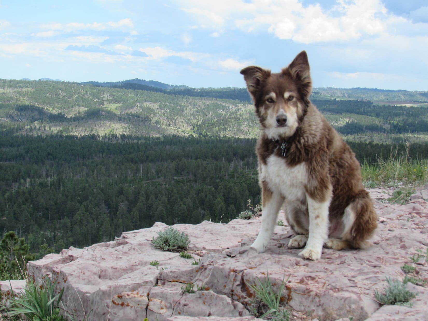
The top of Hat Mountain(6,779 ft.) is a flat oblong close to 80 feet long and half that wide. Bushes grow in a small depression toward the S end, but no trees are found on the summit. Joe and Dusty were impressed with the 360° panoramic views.
Dusty and Joe on the summit. Part of Deerfield Reservoir (R) is in view. Custer Peak(6,804 ft.) is on the far horizon way beyond Dusty. Photo looks NNE.The valley of the N Fork of Castle Creek is seen in the distance beyond Joe. Photo looks NW.Cousin Dusty on Hat Mountain. Dusty was doing mighty well for a 12 year old! She loves visiting the Black Hills where she can roam off leash like Lupe.
While Dusty and Joe pondered the views, Lupe and SPHP went over to get a photo of the old Hat survey benchmark. Set in 1950, it’s looking rather worse for the wear now. The “A” in “Hat” has been completely obliterated, though parts of the “H” and “T” are still visible.
Hey, SPHP! The survey benchmark is over this way, remember? This was Lupe’s 4th ascent of Hat Mountain. Green Mountain(7,164 ft.) is the highest ridge on the L. Photo looks SSE.The Hat survey benchmark is easy to find toward the E side of the summit area.
A week ago on Expedition No. 230, Lupe had gone with Rizzo, Buddy & Josh Hilpert to Ward Draw and K2Peak. Josh had told SPHP about a friend of his who had seen lots of pieces of old Indian artifacts up on Hat Mountain. Although Lupe and SPHP had been on Hat Mountain 3 times before, SPHP had never noticed anything like that up here. Still, it was an intriguing tale, and one of the main reasons Joe had been interested in coming to Hat Mountain today.
An initial scan of the small rocks scattered across the summit area proved disappointing. Joe found a few pieces of rock that looked like they might possibly have been chipped as part of a tool making process, but none even faintly resembled a finished product. SPHP didn’t see anything unusual, and the few poorly chipped rocks Joe came up with didn’t interest Lupe or Dusty at all.
Despite the discouraging results on the summit, Joe wasn’t ready to completely give up on the idea that there might be something of interest here. Joe decided to make an exploratory circle a little below the top of the mountain to see if might be possible to run across something down there. Dusty went with Joe, while Lupe and SPHP hung around up top just enjoying the views.
Joe and Dusty circle the summit of Hat Mountain looking for artifacts. Photo looks NNE.Lupe in the depression at the S end of the summit area. According to the story Josh had told SPHP, there were supposed to be lots of pieces of artifacts here, but even Joe, who is a geologist, couldn’t find anything too interesting. Photo looks SSW.Black Elk Peak (7,231 ft.) (L on the horizon) and Green Mountain(7,164 ft.) (R). Photo looks SE with help from the telephoto lens.Black Elk Peak (L) and Little Devils Tower(6,960 ft.) (R). Photo looks SE with lots of help from the telephoto lens.Lupe a little below the S end of the summit area. Photo looks NE.Joe & Dusty continue circling the summit. Photo looks WSW.
The stroll below the summit was scenic, but unproductive. Joe found even less of interest down below than up on top. The whole artifact deal was basically a bust.
Oh, well. Just looking had been sort of fun. Joe and Dusty returned to the summit for a group photo with Lupe.
Cousin Dusty & Uncle Joe with Lupe on Hat Mountain.
Then it was time to head back down to the G6.
South Castle Rock(6,840 ft.) & Castle Rock(6,783 ft.) (both on L), Nipple Butte(6,800 ft.) (Center), and Flag Mountain(6,937 ft.) (R) from USFS Road No. 691 on the way back to the G6. Photo looks N with help from the telephoto lens.
Upon reaching the G6, Dusty and Lupe were both very much in favor of another refreshing short side trip to cool off in Deerfield Reservoir.
Dusty & Joe back at Deerfield Reservoir. Photo looks NW.Lupe wading in Deerfield Reservoir. Photo looks W.
Then it was back to Grandma’s house for dinner on the deck, fun chasing tennis balls on the front lawn, and the traditional walk up the hill and around the bend to the cul-de-sac.
Start 9:16 AM, 48°F, Boulder Hill Road (USFS Road No. 358) 0.5 mile N of Hwy 16.
Note: Summits on the Air is an awards scheme for radio amateurs that encourages portable operation in mountainous areas. A point system awards points for both transmitting (“activating”) from a mountain or picking up the signal (“chasing”).
Joe & cousin Dusty were in town! That meant one thing – time for some Summits on the Air action! Lupe was all for it. She and Dusty arrived at the top of Silver Mountain around 10 AM. It was a beautiful day to be on the mountain.
Lupe hadn’t been on Silver Mountain in more than 2 years. Although the views are excellent, Silver Mountain is not one of Lupe’s favorites. Target practice gunfire can usually be heard off to the W, which makes her nervous. To Lupe’s dismay, the guns were blazing away again today. Boulder Hill(5,331 ft.) is in view on the L. Photo looks NE.Cousin Dusty just below the summit. The distant gunfire didn’t bother Dusty at all. She paid not the slightest attention to it.Dusty lives in Arvada, Colorado, but was up in South Dakota for a weekend visit. Dusty really likes exploring the Black Hills with Lupe.
Joe had posted notification on the Summits on the Air website that AA0Q (his call letters) would “activate” (start transmitting from) Silver Mountain at 11:00 AM. With an hour to go, he had plenty of time to set up his antenna and portable Ham radio.
Preparations to start transmitting from Silver Mountain included setting up this 16 or 17′ long antenna with four lateral wires at the very summit. Photo looks NE.
Joe said he liked the layout on Silver Mountain(5,405 ft.). The forest had burned years ago, so there were no big trees around to obstruct the views in any direction. The mountain sloped away fairly steeply on most sides with nothing any higher for at least a couple of miles in any direction.
Although Silver Mountain was a good physical setup for Ham radio transmissions, Joe wasn’t at all certain how well things were going to work out. The 11 year sunspot cycle hits its low in just a couple more years, and atmospheric conditions are usually best for amateur radio band transmissions when sunspot activity is high, not low.
As it got close to 11 AM, everything was ready to go. The antenna and portable radio were all set up. SPHP was trained to keep a simple log of Joe’s contacts. Lupe and Dusty were prepared to ward off any intruders.
At 10:55 AM, Joe started transmitting in Morse code, receiving a first response almost instantly. That contact “spotted” AA0Q on SOTA’s website confirming contact with Joe. Silver Mountain was on the air!
An immediate explosion of activity came from dozens of “chasers” all trying to make contact at the same time. AA0Q was overwhelmed by the response, as usual. Joe did his best to make rapid contact with as many of the chasers as possible, but it was impossible to respond to more than a fraction.
AA0Q hard at it shortly after “activating” Silver Mountain. Photo looks SE.Dusty relaxes nearby while Joe works the Ham radio. Response from the chasers, as usual, was initially overwhelming.
Atmospheric conditions were changing rapidly. Joe and the chasers often exchanged signal strength information, which varied wildly over the span of only a few minutes. Of course, part of the variation was due to the different locations of the chasers. Successful contacts were made with operators in Arizona, California, Pennsylvania, the Carolinas and several other states.
With chasers lined up in droves trying to get through, each contact had to be brief.
So, Uncle Joe, how is it going? Heard anything from anyone on Squirrel Mountain, yet? Lupe checks on AA0Q’s SOTA progress. Photo looks E.This photo shows the overall setup. The rocky summit ridge wasn’t the best for comfort, but AA0Q managed pretty well. Photo looks NNE.AA0Q’s portable radio in use on Silver Mountain.
For the first 10 or 15 minutes, conditions gradually improved. Signals were getting a little stronger on average, despite bouncing around. Later on, conditions deteriorated. At times the “bands” were down for a minute or two. AA0Q got a chance to shift to a more comfortable position.
As time went by, the bands went down intermittently, giving Joe a chance to shift to a more comfortable position. Photo looks SSW.
By 11:30 AM, 35 minutes after Joe started transmitting, it was over. The bands were consistently weak. The chasers had either made contact with AA0Q, or given up by now. Even when conditions improved momentarily, no one was left still trying to make contact. Evidently it was time to take down the antenna and put the radio away.
Joe at the top of Silver Mountain shortly before taking the antenna down. Photo looks NNE.Silver Mountain was the 3rd Black Hills peak AA0Q has activated. In July, 2016, Lupe and SPHP had accompanied Joe & Dusty to Custer Peak and Boulder Hill.
AA0Q had made 27 contacts in 35 minutes, so Joe was pleased with the overall results. Despite spotty atmospheric conditions, Silver Mountain had been a successful Summits on the Air outing. There always seem to be way more chasers than it’s possible to make contact with right after activating a peak, but Joe had done all he could.
Lupe got a pat from AA0Q for her guide services.
Lupe earns a pat from AA0Q for her Black Hills peak guide services. Photo looks NE.
Once the radio equipment was put away, it was time for a final look around at the views, followed by a short exploration of Silver Mountain’s summit area. Of course, the most impressive view was toward Black Elk Peak(7,231 ft.), the highest mountain in South Dakota.
Black Elk Peak(7,231 ft.) (R of Center) from Silver Mountain. Hwy 16 is seen below. Photo looks SW.
Silver Mountain’s summit area features two ridges running roughly N/S. The E ridge where Joe had set up the radio equipment is the highest. However, only a short distance to the W is an even rockier and more interesting ridge. The W ridge is only slightly lower than the E one.
The slightly lower, but more dramatic W ridge. Photo looks NW.
Between the two ridges, at the base of the E one, is one of many Dingo outposts Lupe has discovered scattered throughout the Black Hills.
Joe inspects Lupe’s Silver Mountain Dingo outpost. Joe was pretty certain it didn’t meet current building codes, but adventurous American Dingoes don’t give two hoots about that. Boulder Hill is in view beyond it. Photo looks NNE.
Joe was intrigued by the W ridge. He got up on top for a few minutes for a look around. Lupe and Dusty stayed below.
Joe got up on the W ridge for a look around. Slightly lower, Lupe is partially hidden among the small trees on the L, while Dusty sniffs around in the foreground. Photo looks W.
With Silver Mountain’s summit area explored, everyone headed back to the G6. There was still tons of time left in the day. Joe wanted to go climb Boulder Hill (5,331 ft.) again. Everyone piled into the G6. Joe drove 0.5 mile N to the start of the access road only 0.25 mile SW of the summit.
An easy trek along the access road led to a scenic path that winds up the large rock formation at the top of the mountain. Soon Lupe was at the summit with a great view looking back at Silver Mountain(5,405 ft.).
Silver Mountain (Center) from Boulder Hill. Photo looks SSW.
Joe has liked Boulder Hill ever since first climbing it with Lupe, Dusty and SPHP exactly one year ago on 4-22-16. In fact, he liked it so much that first time, everyone had come back to make a second ascent the very next day! On the 4th of July, Joe had even done a Summits on the Air activation of Boulder Hill.
Today’s Expedition No. 201 was Joe and Dusty’s 4th time up on Boulder Hill with Lupe and SPHP. Good times!
Joe on Boulder Hill near the area where he’d done a Summits on the Air activation of the peak on 7-4-16. Back then his antenna had been propped up in the big pine tree seen directly beyond him. Photo looks NW.Joe & Dusty together with Lupe on top of Boulder Hill for the 4th time. The first time up for Joe and Dusty had been exactly one year ago! Photo looks SE.
No Summits on the Air activation of Boulder Hill was planned for today. This was a pleasure excursion, just to see the views.
Silver Mountain (L). Photo looks SSW.Silver Mountain with a little help from the telephoto lens. The more dramatic, rocky W ridge is seen to the R of the true summit. Photo looks SSW.
After lingering at the top of the mountain for 15 minutes, everyone started back down. Time to head back to Lupe’s grandma’s house for food, fun and games. Lupe and Dusty looked forward to an afternoon of squeaker ball, tennis ball and flying disc action in grandma’s front yard. (End 2:00 PM, 62°F)
Joe (lower R) starts the trek down. Photo looks S.Lupe’s cousin Dusty on Boulder Hill. Photo looks E.