Black Hills, SD Expedition No. 219 – Twin Sisters Range High Point & Elk Knob (12-10-17)

Start: 12:24 PM, 58°F at the intersection of Song Dog Road & USFS Road No. 373

Lupe hopped out of the G6.  20 expeditions and almost 8 months ago, she had come here to climb the Twin Sisters Range High Point (4,980 ft.).  She’d made it to the top easily enough, but when she’d gone farther E to explore more of the area, the buzz of an unseen rattlesnake had put a quick end to that notion.

Even though it was an incredibly warm day for December, rattlesnakes weren’t likely to be stirring now.  Lupe should be able to do all the exploring she wanted to today.  The Carolina Dog started out heading E on USFS Road No. 373.

Lupe on USFS Road No. 373 approaching the W end of the Twin Sisters Range. Photo looks E.

A mile from the G6, Lupe left the road and started the short, but steep climb up a SW slope to the W end of the Twin Sisters Range.  Despite a few brief stops for SPHP to catch breath, Looper was soon at the top.

Lupe begins her trek up the short, but steep SW slope. Photo looks NE.
Lupe arrives up on top at the far W end of the Twin Sisters Range. Photo looks WNW.

A dangerous, rusty barbed wire fence was laying on the ground.  SPHP made certain Lupe didn’t get into it.  A 20 mph wind blew out of the NW.  Normally, it would have been frigid here in December with a wind like that.  Today, though, it was so warm out the wind was only a nuisance.

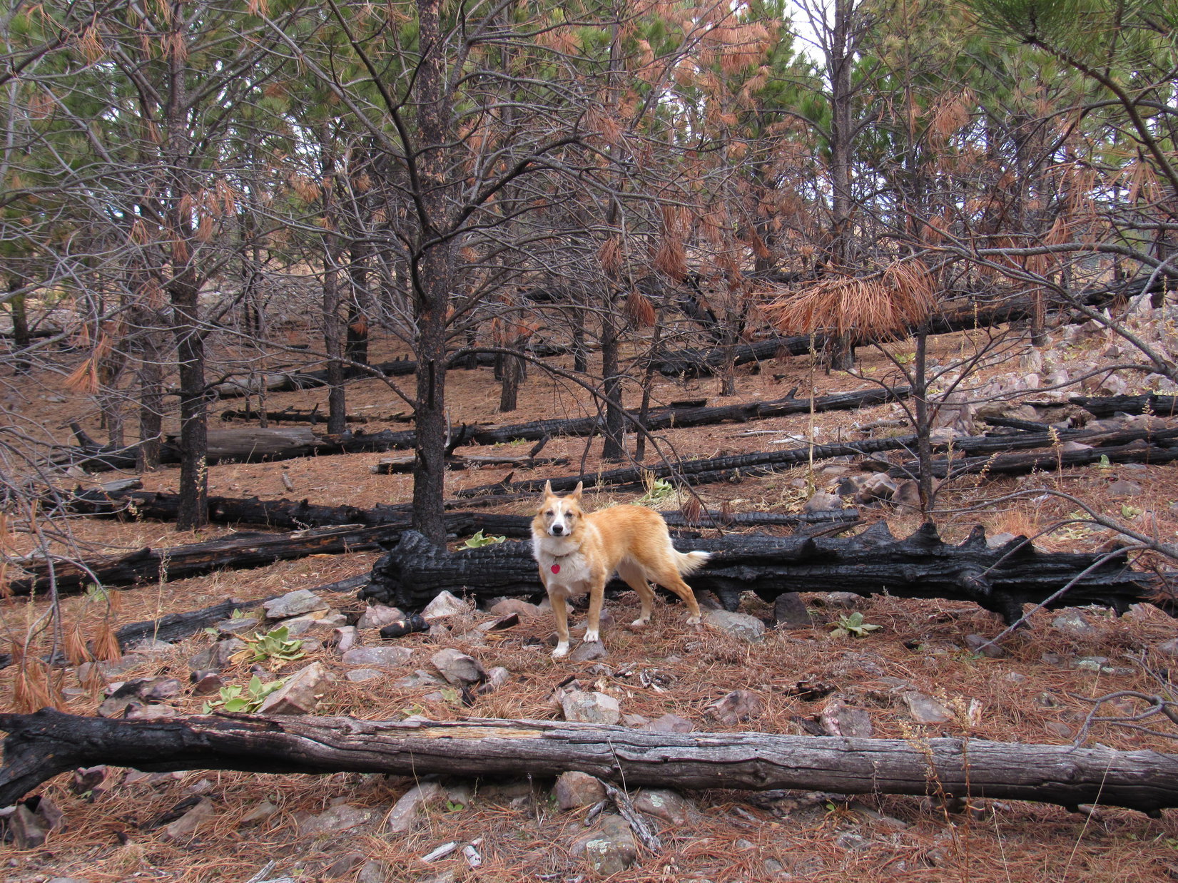
Much of this area had burned in a forest fire years ago.  As a result, Lupe had sweeping views of barren, forlorn vistas.  Dull, dry, dead grass covering the land did little to add any cheer.

The sweeping views Lupe had looked barren and forlorn. High Point 5017 is seen on the L. Photo looks WSW.

The actual high point of the Twin Sisters Range was still another 0.25 mile E.  After enjoying the views from the W end of the ridge, Lupe and SPHP set off for the cairn at the summit.

The summit of the Twin Sisters Range (R) was still another 0.25 mile to the E. Photo looks ENE.
Looper starts for the summit (L). Photo looks E.

The stroll to the summit was easy.  Lupe had great views the whole time from the open ridge.  It wasn’t long before Loop was at the summit cairn.  Of course, the NW wind was blowing here, too.  Not enjoying the wind, Lupe stayed only long enough at the summit for photos by the cairn, and a fairly quick look at the sights.

Looper by the cairn at the top of the Twin Sisters Range High Point (4,980 ft.). It hadn’t taken her long to get here, but the NW wind was as bad as ever. Photo looks E.
Looking SE from the summit cairn. Buffalo Gap is seen in the distance on the L. Elk Knob is the partially forested low hill seen straight up from Lupe’s head (R).
Looking W back along the ridge Lupe had just traveled across.
High Point 5017 is on the far L. Photo looks WSW.
Looking SE farther along the the Twin Sisters Range. Buffalo Gap (Center) is near the horizon. Elk Knob is the low mostly forested hill on the far R.
The pine-dotted hill on the R is at the lower E end of the Twin Sisters Range. Photo looks E with help from the telephoto lens.

Loop and SPHP left the Twin Sisters Range High Point continuing E down to a lower part of the ridge.  Loop regained some lost elevation climbing up to High Point 4872.  High Point 4872 was windy, too, but Lupe paused briefly for a few photos.

Looking back at the Twin Sisters Range High Point (seen straight up from Loop) from High Point 4872. Photo looks NW.
Elk Knob (4,752 ft.) (R) from High Point 4872. Lupe would be going to Elk Knob next. Photo looks SE.
High Point 4820 is on the L. Buffalo Gap is R of Center. Looking SE from HP 4872.

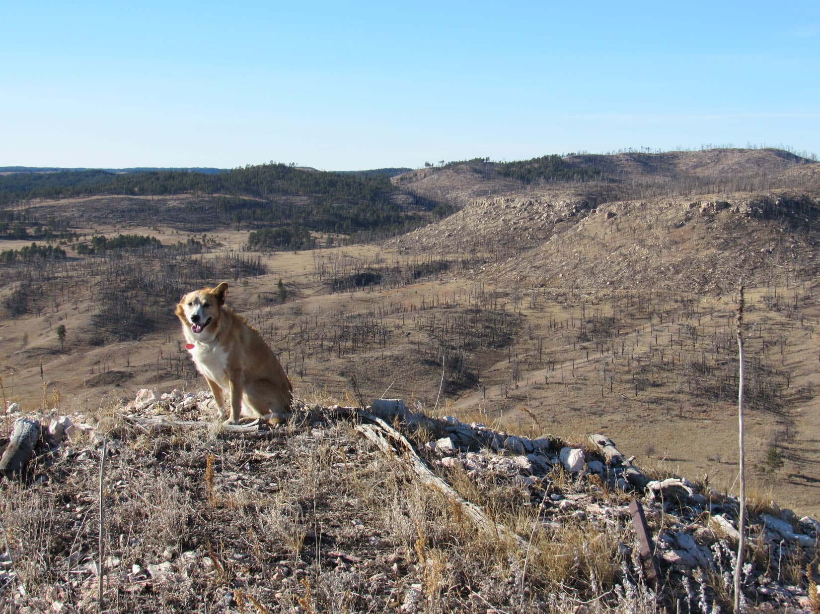
At High Point 4872, Lupe was already well beyond where she’d been back in April on Expedition No. 199.  The topo map showed another lower hill a mile off to the SE known as Elk Knob (4,752 ft.).

Elk Knob became Lupe’s next objective.  She started down High Point 4872’s S slope, and was quite happy when she finally reached a valley where the wind was barely stirring.

On the way down High Point 4872’s S slope. The Twin Sisters Range High Point is in view on the R. Photo looks NW.

The trip up Elk Knob was easy.  Lupe first went to a saddle N of the hill, then followed the N slope up.  The hill was heavily forested, until she got near the top.  Lupe liked being in the forest on Elk Knob a lot better than on the bare, windy Twin Sisters Range ridge.  She had a good time racing around sniffing and exploring.

The summit of Elk Knob proved to be a big, flat grassy area rimmed with pines.  The pines were dense toward the N, but more sparse elsewhere.  For a fairly low hill in this area, Elk Knob had some pretty good views.  The wind wasn’t too bad, either, except near the more exposed W end.

Lupe on the big, flat grassy summit of Elk Knob. Photo looks S.
The view to the S was surprisingly open and nice. Lupe could see quite a long way from here. Photo looks S with help from the telephoto lens.
Happy Lupe on Elk Knob.
Here Lupe is down a little off the summit on Elk Knob’s upper W slope. It was windier here than elsewhere, but she could see the Twin Sisters Range High Point (on the R straight above her head), and much of the territory she’d just traveled through. Photo looks NW.
View to the NNE from Elk Knob.

Lupe took a break on Elk Knob.  The usual water and Taste of the Wild, with an apple for SPHP.  Then it was time for more exploring.  Loop went NE down off Elk Knob, before turning E and SE.  She wandered along several dirt roads.  Only one had a sign, which said she was on USFS Road No. 373.1D.

The Carolina Dog ventured down into a fairly deep canyon.  She followed a faint remnant of a road at the bottom, but it eventually ended.  Loop climbed up the NE side of the canyon, and reached a ridge she took SE.  The sun was getting low by the time she reached a big fence.  This had to be the fence along the W side of Wind Cave National Park.

Lupe explored territory E of Elk Knob until she got to this big fence somewhere along the W boundary of Wind Cave National Park. Photo looks SE.

The fence was as far E as Lupe could go.  It was getting late enough so she needed to start back anyway.  On her return trip she avoided the canyon by staying farther N.  She eventually passed back over the saddle N of Elk Knob heading NW.

The sun wasn’t quite down yet as Lupe neared the Twin Sisters Range again.  Why not return to the summit?  Well, there was the wind, for one thing.  It wasn’t bad at all down here, but was still blowing up there.  However, seeing the sunset from a mountaintop seemed more important.  Up Lupe went.

Climbing the Twin Sisters Range again, this time from the S. Photo looks NW.
Nearing the Twin Sisters Range High Point (L) for a second time today. Photo looks N.

The last bit of the sun was disappearing behind High Point 5017 when Lupe reached the Twin Sisters Range High Point (4,980 ft.) again.  The sky was almost completely clear, with only a few small clouds to the W.  With so few clouds, the sunset never really got a chance to develop into anything special.

Lupe reaches the Twin Sisters Range High Point for the 2nd time today, just as the last bit of the sun slips below HP 5017. Photo looks W.

For a little while, Lupe and SPHP sat together in the wind on the barren, forlorn mountaintop, watching the light fade until hopes for a colorful sky died old and gray.  Time to go.

Being on the move again felt good.  It was fun picking a way down the steep rocky slope, and marching across a field back to the road.  Next came a mile of shared silence and solitude beneath a darkening sky.  At the G6, a few stars glittered above.  Water, a little more Taste of the Wild, and Lupe was homeward bound.  (5:03 PM, 46°F)

On the Twin Sisters Range High Point right after sunset, 12-10-17

Links:

Next Black Hills Expedition                  Prior Black Hills Expedition

Black Hills, SD Expedition No. 199 – Twin Sisters Twice & Castle Rock (4-12-17)

Want more Lupe adventures?  Check out her Black Hills, SD & WY Expeditions Adventure Index, Master Adventure Index, or subscribe free to new Lupe adventures!

Black Hills, SD Expedition No. 218 – Mt. Coolidge (12-3-17)

A mile N of Hazelrodt picnic ground, SPHP parked the G6 off USFS Road No. 341 at a pullout by French Creek (10:28 AM, 50°F).  Lupe leapt out.  She ran down to the creek for a look.  Even though the last 3 weeks of November had been very warm and dry, the edge of the stream was rimmed with ice.

Early December and yet another unseasonably warm day. Not a single snowflake on the ground, but Lupe did find ice along the edges of French Creek.

Mt. Coolidge (6,023 ft.) was Lupe’s peakbagging goal for Expedition No. 218.  She’d been there once before, but it had been a very long time ago.  Lupe had only been 15 months old when she’d climbed Mt. Coolidge for the first time way back on Expedition No. 13.

Today Lupe was trying a new route.  She would explore the mountain’s SW ridge.  The Carolina Dog started out traveling ENE on the S side of French Creek.  At first, she was in a forest of large pines that had been thinned out.  This was easy ground, but didn’t last long.  Soon Loop was leaving French Creek and the large pines behind.

Looking down on French Creek. Photo looks N.

The climb up the SW ridge began in earnest on a steep slope crowded with young pines.  After gaining close to 150 feet of elevation, Lupe reached a small rocky ridge.  Off to the SW, she could see the NE face of Northeast Cicero Peak (6,240 ft.).

After gaining nearly 150 feet of elevation, Lupe reached this small rocky ridge where she had her first distant views. Northeast Cicero Peak is the big hill on the L. Photo looks SW.

Beyond this first small ridge, Lupe passed through a forest of larger pines again.  She emerged from the forest at the edge of a big meadow.  Ahead was a sparsely forested hill.

Beyond the first small ridge, Lupe passed through a forest before reaching this grassy meadow. The sparsely forested hill ahead was Lupe’s next destination. The fence at Center is the W border of Custer State Park. Photo looks NE.

Looper headed for the hill.  When she reached the top, she got her first look at Mount Coolidge ahead.  Behind her, the view of Northeast Cicero Peak was better than before.

Loop gets her first look at Mt. Coolidge (R of Center) ahead. Photo looks NE.
From the sparsely treed hill, the view of Northeast Cicero Peak (L) was better than before. Photo looks SW.

Lupe turned E following a ridgeline.  Much of the area had burned at some point, which opened up views in various directions.

Looking S from an opening on the ridgeline.

The irregular ridge wound E and N.  Lupe came to a succession of high points, each one higher than the last.  The high points were separated by shallow saddles where Looper lost a bit of elevation, but she always regained it quickly.

It was too bad this was such an overcast day.  A little blue sky and sunlight would have made some of the views far more striking.

At the next high point. Custer Mountain (6,089 ft.) is the biggest forested hill L of Center. Photo looks NW.
Getting closer! Mt. Coolidge is seen beyond Lupe. She would be heading for the almost barren hill on the L next. Photo looks NE.
Much of the ridge Lupe was following had burned at some point. There were still live trees, but most were young. Photo looks NE.
Looper in a saddle on the way to the next high point. Mt. Coolidge is on the far R. Photo looks N.

Lupe had a good time sniffing and exploring.  She was making progress, too.  Each time Mt. Coolidge came into view, she was closer than before.

Each time Mt. Coolidge (Center) came into view, Lupe could see she was making progress. Photo looks NE.
Looking back to the SW again. Northeast Cicero Peak (L), Daisy Peak (5,948 ft.) (R of Center), and Kruger Peak (5,838 ft.) (far R) are all in view.
Looking S back down the ridge Lupe came up.

After more than a mile on the winding, partially burnt ridge, Lupe finally reached the end of the burn area.  The last couple of high points she came to were far more heavily forested.  On one slope, spindly dog hair pines grew so thickly, it was slow going trying to force a way through.

Loop reaches a high point near the end of the burn area. Hwy 87 is in view on the L. Photo looks ENE.
SPHP designated this rock outcropping “Big Pine” due to a scattering of far larger pine trees here than any Loop had come to for a while. Mt. Coolidge in the background. Photo looks NE.
NE of “Big Pine” Lupe passes through a thick dog hair forest leading down into the deepest saddle of the whole journey to Mt. Coolidge. With the trees so close together, this area was slow going for SPHP. Photo looks NE.

After passing through the dog hair pine forest, Lupe arrived at the bottom of the deepest saddle of her whole trek to Mt. Coolidge.  She came across a dirt road here, but followed it only a little way.  She left the road to start the longest, steepest part of the climb up Mount Coolidge.  The forest had been thinned here, and the slope was full of leftover slash.

Lupe reaches the longest, steepest part of the climb up Mount Coolidge. The forest had been thinned here, and the whole slope was covered with leftover slash. Photo looks NE.

Near the top of the long slope, the slash gave way to jumbled rocks.  The rocks were easier to deal.

Near the top of the long slope, the slash gave way to jumbled rocks. Photo looks NNE.

The rocky part led to a larger rock outcropping at the SW end of a nearly level ridge.  Loop was now so close to Mt. Coolidge that she could see the road that leads to the lookout tower on top.

At the top of the long slope, Lupe reaches a rock outcropping. Mt. Coolidge is now so close that the access road to the lookout tower is in view. Photo looks NE.
Looking back at Northeast Cicero Peak (Center) from the rock outcropping at the end of the long slope. Photo looks SW.

Loop headed for the access road.  Once she reached it, she stayed on it the rest of the way.  It circled around to the N clear over to the opposite side of Mt. Coolidge. Lupe ended up approaching the summit from the NE, even though she had spent nearly all her time coming up the SW ridge.

Approaching the lookout tower at the top of Mt. Coolidge. Photo looks SW.

The access road is closed this time of year.  There wasn’t a soul around when Lupe and SPHP reached the top of Mount Coolidge (6,023 ft.).  The first thing Loop did was check out the lookout tower.

Looper at the lookout tower. Photo looks SW.
View to the SSW from the tower’s observation deck. Northeast Cicero Peak (6,240 ft.) is on the R.
View to the NNE from the observation deck.

Lupe went up to the observation deck.  A sign said no Dingoes allowed.  Hmmph!  Loop didn’t stay long before retreating, since that’s the way they wanted to be about it.

Lupe and SPHP went over to the NW side of the summit area.  Some of the highest territory in the Black Hills was in sight.  After a few photos, it was time for a break.

From the NW side of the summit area Lupe could see some of the highest mountains in the Black Hills. Sylvan Hill (7,000 ft.) is the high point on the horizon directly above Lupe. Photo looks NW.
Little Devil’s Tower (6,960 ft.) (L) and Black Elk Peak (7,231 ft.) (Center) are on the horizon. The Cathedral Spires (6,840 ft.) are between them. Photo looks NNW.

Lupe drank some water, then curled up on the ground next to her silver bowl.  She ate a little Taste of the Wild, but not too much.  There hadn’t been much of a breeze at all on the way up, but now a chilly wind blew out of the SW, moaning in the trees and antenna wires.  In solitude, Lupe and SPHP gazed out across the hills.

Lupe was last here 205 Expeditions ago.  More than 5.5 years had gone by.  The first time she’d come, Loop was still basically a puppy.  SPHP sat petting Lupe, stroking her soft fur.  Her birthday was coming soon.  Not long afterwards, 2017 would draw to a close.  Time marches on.  Best not to think about it too much.

C’mon, Looper!  Guess we’ve seen what there is to see up here today.  Too bad the sun didn’t come out.  Mt. Coolidge is a sweet viewpoint, but the light just isn’t what it might have been.  All our photos are kind of faded and washed out.  I feel kind of the same way for some reason.

Loop was ready.  One more photo before going, then the Carolina Dog took off down the mountain.  She went SW, skipping most of the winding route the access road takes, and headed directly for the SW ridge.

Last photo from Mt. Coolidge before departing for the SW ridge again. Photo looks E.

It felt good to be on the move again.  Going back down Mt. Coolidge’s long SW ridge with all its ups and downs, twists and turns, was fun.  Lupe had a blast sniffing and investigating whatever caught her attention.

The G6 was only 2 miles away.  SPHP was surprised at how late it was when Lupe got back (3:37 PM).  Less than 1.5 hours of daylight remained.  Still time enough to do a little something, but not what SPHP had originally intended.

Half an hour’s ride in the G6 brought Lupe to a trailhead (4:11 PM, 52°F).  The sky had finally started clearing off, but sunset was imminent.  As light faded, Lupe enjoyed a mile long trek.  At first she followed a creek, but most of the way was over a rolling prairie with views.  Clouds brightened, then darkened again as the sun abandoned the Black Hills.

Loop reached a minor high point, only a small hill, but a peakbagging goal nonetheless.  By now it was so dark, the flash had to be used.  No dawdling!  This was it for Expedition No. 218.  Lupe turned and started back.  SPHP hurried, trying to keep up, as the Carolina Dog headed for home (5:23 PM).

On another hill at day’s end, 12-3-17.

Note:  Most visitors to Mt. Coolidge drive to the summit on a wide, gravel access road which originates along Hwy 87 in Custer State Park.  The access road is closed during the off-season.

Links:

Next Black Hills Expedition                Prior Black Hills Expedition

Want more Lupe adventures?  Check out her Black Hills, SD & WY Expeditions Adventure Index, Master Adventure Index, or subscribe free to new Lupe adventures!