Start – Cascade Springs picnic ground at J. H. Keith Memorial Park along Hwy 71, 10:02 AM, 34°F
Blue sky! A welcome sight! This day was going to be fine after all.
Good thing, too. It had been a while, and Lupe was anxious to get back out in the hills. The forecast was for the first near normal temperature day since March, a vast improvement over April’s chilly start. However, on the way here SPHP had begun to wonder. The sky had been so darkly overcast and the clouds so low, that SPHP had driven through stretches of fog with the headlights on. The temperature had sunk to a pathetic 14°F. Mighty brisk for nearly a third of the way into April!
It was 20°F warmer here at the Cascade Springs picnic ground, though. Not a particularly bright day, but Looper was at least going to get some sunshine. She was eager to get going, and was soon happily sniffing her way along Hwy 71.
Loop left Hwy 71 at USFS Road No. 328. The dirt road followed Cascade Creek SW for 0.33 mile before turning N to climb out of the creek valley. The road brought the Carolina Dog up onto the low end of a long ridge. Devil’s Slide Mountain(3,965 ft.) was in view to the SE.
Near Cascade Creek. Photo looks S.Devil’s Slide Mountain (L) from the start of the ridge. Photo looks SE.
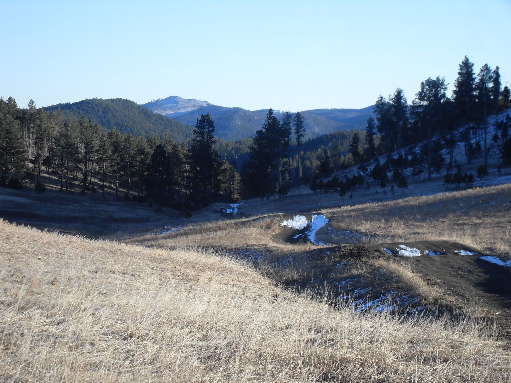
Once up on the toe of the ridge, USFS Road No. 328 turned NW following the ridge higher. Lupe was gaining elevation steadily at an easy pace. The broad ridge was mostly grassland, but pine trees were never far away. The views back to the S kept improving as Looper went higher.
The views were gradually improving as Lupe followed the ridge higher. Photo looks S.
Loopster was excited to see a small herd of deer. The deer noticed the Carolina Dog, too, but weren’t as thrilled to see Lupe as she was to see them. After a moment’s hesitation, they retreated to a nearby forest.
Lupe was excited to see this small herd of deer. When the deer saw Lupe, they decided to head for a nearby stand of pines.
This was dry country at the far S end of the Black Hills. SPHP could see cactus hidden among the grass. The cacti weren’t super abundant, but were definitely a clear and present danger for Lupe. Loop must have sensed that cactus was around. Without any prompting from SPHP, she played it safe and stayed right on the road.
After the deer, Lupe didn’t see much else of interest until she had been on the ridge for nearly 0.75 mile. Here she passed between a couple of low hills, and came to a tiny reedy pond. The pond didn’t have much open water at all, but frogs were singing merrily. When Loop got close, they suddenly went silent.
After following the ridge nearly 0.75 mile, Lupe came to this reedy pond where frogs were singing. Photo looks NW.The pond didn’t have much open water, but the frogs seemed happy enough with it. Photo looks S.
Lupe kept going. 0.25 mile beyond the frog pond, the ridge narrowed down substantially. This area was forested, but didn’t extend far. Soon Lupe was emerging from the trees again. Ahead the road went up a very broad grassy slope.
When Loop was nearly 2 miles past the frog pond, the road crested. Past this point, No. 328 dipped slightly and bent N. From the crest, Lupe could see Horse Trap Mountain(4,682 ft.) 3 miles to the NW. She had been to Horse Trap Mountain once, more than a year ago.
Why, SPHP, look! There’s Horse Trap Mountain (R) up ahead. Remember being there? …. Sure do, Looper! It was a pretty cool spot. Photo looks NW.
Returning to Horse Trap Mountain was tempting, but not the plan. Lupe’s actual peakbagging objective was in sight from here. From the little crest, the road curved N toward Roundtop Hill(4,469 ft.).
Mighty Roundtop Hill (R of Center) was today’s peakbagging objective. Photo looks N.
Lupe and SPHP had first seen Roundtop Hill from Horse Trap Mountain on Expedition No. 197. However, there hadn’t been time enough to get over to Roundtop then. Loopster was going to get there today, though!
Before continuing on to Roundtop Hill, Lupe and SPHP took a break at a stand of pines W of the crest in the road. Along the SW edge of these trees was a grouping of yucca plants. The yuccas looked pretty snazzy, so Lupe thought she might like a photo. SPHP helped her watch out for the plentiful cacti growing nearby.
Lupe by the snazzy yucca plants W of the crest in the road. Photo looks SSW.
Roundtop Hill was still 1.5 miles away as the crow flies. After a short break, Lupe and SPHP hit the road again.
Ready to hit the road again for Roundtop Hill (R). Photo looks N.Roundtop Hill with help from the telephoto lens. Photo looks N.
USFS Road No. 328 headed straight for Roundtop Hill until it got close. Then it swung around the W side of the hill. Instead of going directly to the summit, or at least the saddle W of it, Lupe stuck with the road. As she approached the W end of Roundtop Hill, the Carolina Dog had some nice views of Falls Canyon.
Nearing the W end of Roundtop Hill, Lupe could see Falls Canyon. Photo looks SSW.Looking WSW across an E branch of Falls Canyon.
Circling the W end of Roundtop Hill the road became steeper. By the time Lupe was around to the N side, she had already gained almost all of the elevation she needed to in order to reach her objective.
The summit of Roundtop Hill was now 0.5 mile ESE. Leaving the road, Lupe approached a deadfall strewn slope beyond a power line. The trees had all died in a wildfire a long time ago. Only one dead tree was still standing. A Devil Tree stood slightly below the top of the slope. Lupe headed for it.
Lupe reaches the Devil Tree at the WNW end of Roundtop Hill. Photo looks ESE.
Past the Devil Tree, Lupe came upon a surprisingly flat grassy area. She could now see the summit of Roundtop Hill ahead. Getting there looked easy. As it turned out, there was virtually no cactus up here, either, which made the trek to the summit ridge both simple and fun.
Oh, we’re almost there, SPHP! Roundtop Hill (L) is in the bag! Photo looks ESE.Loopster nearing the summit ridge. Photo looks ESE.
Roundtop Hill’s summit ridge runs NW/SE, and is hundreds of feet long. It’s quite narrow at the NW end where big boulders of pockmarked sandstone are prominent, and much wider toward the lower SE end. Lupe started her quest for the true summit by climbing up among the boulders at the NW end.
It’s kind of interesting up here, SPHP. Come on up and see for yourself! Lupe at the NW end of Roundtop Hill’s summit ridge. Photo looks SE.
The top of Roundtop Hill used to be forested. However, a fire had killed every living tree. When Lupe reached the summit ridge, the bleached white trunks and branches of the small trees that used to live up here were scattered all over among the rocks. The jumble of dead wood made moving around more difficult than it should have been.
The true summit of Roundtop Hill (4,469 ft.) was a large flat boulder 40 feet from the big rocks at the NW end. A couple of other rocks along the SW edge were also in contention for the title. Lupe ultimately visited all of the highest rocks.
Lupe at the true summit of Roundtop Hill. A couple of other rocks nearly as high are seen to the R. Photo looks S.On a perfect Dingo display rock along the SW edge of the summit area. Photo looks W.
A chilly 20 mph NW breeze was blowing. The temperature couldn’t have been much more than the mid 40’s °F. After tagging the true summit, Lupe and SPHP went to the lower SE end of the summit area. This area was protected from the wind, so it was a good place to take a break.
Pockmarked sandstone was plentiful. Standing water filled many of the holes in the rocks. Lupe and SPHP took a break at Lake Rock. Loopster enjoyed drinking freely from the tiny lakes. SPHP supplied her with Taste of the Wild.
Loopster at Lake Rock. She took a break here, sampling the water from several of the lakes. Photo looks WNW.What a great spot! Help yourself SPHP! There’s plenty of water to go around.
The best views from Roundtop Hill were generally toward the S. Lupe could see a number of peaks she had been to before.
This was one of the best views from Roundtop Hill. Flagpole Mountain(4,320 ft.) is at Center far beyond Lupe. Photo looks SE.Three peaks Lupe had been to before are lined up in the distance. The ridge L of Center is Seven Sisters Range(4,420 ft.). At Center above Loop’s rump is Peak4371. Straight up from her head is Peak 4310. Photo looks E.The long ridge beyond Lupe is Horse Trap Mountain(4,682 ft.). The smaller ridge in the distance at far R is Parker Peak(4,848 ft.). Photo looks WNW.
It would have been fun to go back to Horse Trap Mountain, but a check of the maps showed that it was probably best to just stay here and enjoy Roundtop Hill. Getting past Falls Canyon would take too much time. So Loop and SPHP lingered up on Roundtop Hill for well over an hour just chillin’ and enjoying the views.
Looking N along the summit area. The dead trees were kind of a mess.Looper at one of the highest rocks along the SW edge. She could see a long way from here! That had to be Nebraska on the horizon. Photo looks SSW.Same spot with help from the telephoto lens. On the way to the Roundtop Hill area, Loop had come up from the L along the grassy slope beyond her. Photo looks SSW.Lupe’s final approach to Roundtop Hill’s summit ridge had been from this direction. Horse Trap Mountain is in the distance on the L. Photo looks NW.Among the big boulders at the NW end of the summit area. Photo looks WNW.Up on one of the more dramatic rocks. Photo looks SE.This was kind of a cool rock formation, too. On her way back to the G6, Lupe would go to the pines (L) seen beyond her, then on to the Devil Tree, which is out of sight over the near ridge a little to Lupe’s R. Photo looks WNW.
Lupe and SPHP wandered slowly along the SW edge of Roundtop Hill gazing at the views. When Loop reached the last big boulder up at the NW end, it was time for a final dramatic Dingo pose.
Lupe at the last big boulder at the NW end of the summit. Photo looks SSE.View to the N before the final descent.
On the way back to the G6, Lupe simply retraced her original route to Roundtop Hill. She returned to USFS Road No. 328 near the Devil Tree, then just followed the road back. Getting back to the Cascade Springs picnic ground was close to a 5 mile trek, but it was a pleasant, easy stroll. Lupe had gained nearly 1,100 feet of elevation on the way to Roundtop Hill. She now had gravity on her side.
Roundtop Hill had been fun! The views had been impressive for no higher than it was, and this far S end of the Black Hills is an area Lupe had only explored occasionally before. Now she’d seen another piece of the puzzle.
Roundtop Hill worked out pretty well, didn’t it, SPHP? When I first saw how little it was, it didn’t seem like much, but we could see clear to Nebraska! Photo looks SE.
Plenty of daylight remained when the American Dingo reached the G6. (4:20 PM, 57°F) Cascade Falls, one of her favorite places in this part of the Black Hills was only a few miles from here. So SPHP drove Loop to Cascade Falls for a little while to sniff around and see the clear water tumble into the swimming hole. No one else was around.
A quick visit to Cascade Falls was an end of the day treat.
In an over-crowded world, that just made it seem that much better.
On Roundtop Hill, Black Hills of South Dakota, 4-9-18
Phooey! We aren’t going to lay around wasting the whole day watching it then, are we? I love playing football and scoring touchdowns, but just watching is so dull. I would watch it if the Dingoes were playing, though.
Well, what would you like to do instead?
Can we do an expedition? Please, please, please! Can we? Can we?
Kind of a cold day for it, but yeah, we can go.
Several concrete barriers blocked the way forward, but left enough room to park the G6 at a little pullout along Sheridan Lake Road (10:36 AM, 29°F). It was still another mile or so to the turn S onto Boulder Hill Road, but this ought to be about far enough. Lupe and SPHP walked downhill going NE along Sheridan Lake Road.
Lupe soon left the road to explore a forested draw coming down from the NW. She was in the upper end of the Dutch Creek valley. Dutch Creek is only a tiny, mile long seasonal stream that flows into Spring Creek a little farther S. Lupe found no water in it today.
At first, the Carolina Dog wasn’t following any sort of road or trail going NW up the draw, but she eventually found a trail on the NE side. Near the end of the valley, the trail angled N and climbed up over the rim of the draw onto a flat area. Most of this large flat area was forested, too, but Lupe found a spot toward the SE where she could see Boulder Hill(5,331 ft.). Nearly 3 miles to the S, Boulder Hill looked considerably higher than where she was now.
Up on the flat ground, the trail Lupe had been following went NE. She stuck with it for only a short distance. There wasn’t much of a plan for Expedition No. 76. SPHP was hoping Lupe might find the mysterious Pink & Black Checkered Trail she had come across on Expedition No. 75. She could then continue her explorations farther W. However, it seemed likely Lupe needed to go N or W from here, and this trail was turning E.
Lupe left the trail heading N, but soon had to turn W to avoid losing a bunch of elevation. She found more trails and wound up close to where she’d climbed out of the draw, having made a big circle to the NE through the forest. A little to the N, there had been a trail going W, so Lupe went back to take it. This new trail continued W for a little while, then zig-zagged N up a slope to an area which seemed vaguely familiar.
The trail had reached an old logging road on the upper S side of a hill. Hadn’t Lupe climbed this very same hill to get a view late in the day on Expedition No. 75? SPHP was almost certain of it. Lupe followed the logging road W. She arrived at a junction at a saddle. Yes, Lupe had been here before! On Expedition No. 75, the Pink & Black Checkered Trail had led Lupe to this point coming up from the ravine to the N. She could now go N back down the ravine to the Victoria Creek valley.
Lupe followed a logging road on her way down the ravine. Pink & Black Checkered markers were tied to some of the trees along the way. Lupe lost 400 ft. of elevation over the course of a mile before reaching Victoria Creek in a larger valley. The creek bed was dry and full of stones. This was as far W as she had gotten on Expedition No. 75.
The logging road turned W as it reached the Victoria Creek valley. Lupe followed the road W, but saw no more Pink & Black Checkered markers from here on. She had only gone another 100 yards, though, when a gravel road came into view ahead. The logging trail went right to it. This had to be a USFS Road, but no signs or markers were in sight.
Victoria Creek valley split in two here. Lupe could follow the USFS Road either SW or N depending on which of the two branches she wanted to explore. SPHP led her N. The road went around a bend, gradually gaining elevation and curving NW. Lupe quickly arrived at another intersection with another gravel road coming in from the NE. A marker showed that road was USFS Road No. 159.
Time for a break. At the intersection, Lupe had Taste of the Wild. SPHP ate an apple while checking the old USFS map. The map showed that No. 159 is Victoria Lake Road. The road Lupe had followed to this point was No. 162.
Looking SE back down USFS Road No. 162, which Lupe had followed to this point at the intersection with Victoria Lake Road.Lupe waits to hear SPHP’s verdict on where she is now? She was at the intersection of Victoria Lake Road and USFS Road No. 162.
After the break, Lupe and SPHP headed NW on Victoria Lake Road. The USFS map showed that the Brush Creek trailhead of Centennial Trail No. 89 was only another 3 miles in this direction.
Following the wide gravel road was a bit dull, so when a jeep trail appeared paralleling it closer to Victoria Creek, Lupe took the jeep trail instead. She soon made a discovery! Lupe found a piece of a deer leg, with the hoof still attached. By all appearances, the poor deer had met its unfortunate end quite a while ago, but Lupe considered the deer leg a most valuable find. She trotted along carrying the deer leg proudly for quite a distance before finally tiring of it.
The trek along the jeep trail was easy and scenic. Beyond Victoria Lake Road on the L (SW) was a high forested hill. To the R (NE) a long wall of rock kept Victoria Creek confined in the little valley Lupe was exploring. The valley was nearly flat and only partially forested. Lupe was gaining elevation slowly. Occasionally the jeep trail crossed Victoria Creek, which had flowing water some places, but not others. Lupe had no problems crossing the creek.
Once in a while, the terrain temporarily forced Lupe off the jeep trail and up onto Victoria Lake Road. During one of these stints, a side road appeared leading up another valley to the SW. The side road had several inches of snow on it. A marker said this was USFS Road No. 159.2E. A couple of boulders barred this route to vehicles.
No. 159.2E looked intriguing. Lupe passed between the boulders, leapt over Victoria Creek, and started following the snowy road. She had to leap over Victoria Creek a couple more times before it disappeared underground, or at least beneath the snow. The snow was deeper than SPHP had thought. Soon No. 159.2E all but vanished beneath the snow, too. Only a single track trail remained.
Lupe was romping in a snowy field on her way to an inviting sunlit part of the valley when SPHP was surprised to see a Centennial Trail marker over by the edge of the forest to the S. Lupe had reached the trail sooner than expected! Which way to the Brush Creek trailhead? SPHP was almost certain it was still to the N, but had Lupe follow the Centennial Trail along the edge of the forest S for a little way to be certain. No, it wasn’t over here. A quick check of the USFS map confirmed that it had to be farther N.
The American Dingo never did make it to that sunlit part of the valley. Instead, she followed Centennial Trail No. 89 going N. She crossed Victoria Lake Road again on the way, and arrived at the Brush Creek trailhead down in a deep valley. She continued past the trailhead following a snow-packed road.
The road wound NE below increasingly impressive high rock walls while losing elevation steadily. The deep valley became a shady, chilly canyon. Although Lupe had explored virtually the entire Centennial Trail way back in 2012 when she was still practically a puppy, SPHP couldn’t remember exactly where the trail left this canyon. After going some distance, the road started turning E.
SPHP began to suspect the USFS map was wrong. It showed the Brush Creek trailhead along Victoria Lake Road. It finally dawned on SPHP that the trailhead is actually along a minor side road. A more careful examination of the map confirmed this was a possibility. Ack! Lupe was going the wrong way!
Lupe and SPHP turned around. Lupe went all the way back past the Brush Creek trailhead again. The road gained elevation steadily the whole time. Lupe finally reached a junction with Victoria Lake Road. Whew! Back on track.
By now, SPHP had decided it might be fun for Lupe to circle around to the W, and then S and E through the Bald Hills. The Bald Hills are a few square miles of rolling grasslands located NW of Twin Sisters(5,244 ft.) and E of Hwy 385. Lupe went W on Victoria Lake Road looking for USFS Road No. 161, which would take her to the N edge of the Bald Hills.
Lupe hadn’t gone far on Victoria Lake Road at all, when a side road appeared going WSW up a lovely open valley where tiny Brush Creek originates. It was tempting to follow this side road, but SPHP could see a marker for another side road not too much farther ahead. This second road proved to be USFS Road No. 161, the one Lupe had been looking for.
No. 161 climbed up onto a small ridgeline where it went up and down over a series of small hills continuing W through the forest. After more than 0.5 mile, the road emerged from the forest. Lupe had reached the N edge of the Bald Hills.
When USFS Road No. 161 finally emerged from the forest, Lupe found herself along the N edge of the Bald Hills. Photo looks SE.The Bald Hills are 2 or 3 square miles of rolling grasslands within the Black Hills National Forest. They are E of Hwy 385 several miles S of Pactola Lake. The highest of the Twin Sisters(5,244 ft.) is seen in the distance on the R. Photo looks SE.
The open views across the prairie were fun to see after spending much of the day in the forest. Lupe continued along No. 161 as it curved around the NW corner of the Bald Hills. Eventually she reached an intersection with USFS Road No. 160.1, which went E.
The slanting rays of sunlight said Lupe was as far W as she should go today. She was a long way from the G6. SPHP was beginning to realize Lupe wouldn’t get back before dark.
USFS Road No. 160.1 heads E from its intersection with No. 161. Lupe took this road on her way back to the G6, but only stayed on it partway through the Bald Hills. Photo looks ESE.
Lupe went E on No. 160.1 for a little way, but began to lose significant elevation going down a draw. The map showed the road would eventually turn S. The Carolina Dog would have to regain all this lost elevation as the road climbed back up to the pass between Twin Sisters.
Hoping to avoid at least some elevation loss, Lupe left the road taking a shortcut going SE directly toward Twin Sisters. This SE route proved to be so up and down it was doubtful whether any real net benefit was gained. Lupe did save some distance, however.
As Lupe neared Twin Sisters, a rowdy flock of crows captured her attention. They flew off as Lupe ran over to bark at them. By the time she came running back, SPHP had reached No. 160.1 at the top of the pass. From here, the road went SSE between Twin Sisters losing elevation steadily again.
USFS Road No. 160.1 heads SE between the Twin Sisters losing elevation all the way. Silver Mountain is in view in the distance. Photo looks SE from the high point at the pass.Another look at Silver Mountain(5,405 ft.) (in the distance on the L) with a little help from the telephoto lens. Photo looks SE.
The trek down No. 160.1 between Twin Sisters looked inviting, but with the sun getting lower by the minute, SPHP thought maybe it was best to check the map. It showed No. 160.1 would go 1.5 miles before reaching No. 162. Lupe would then have to follow No. 162 another 2.5 miles NE just to get back to the Pink & Black Checkered Trail.
On the other paw, cutting almost straight E to Boone Draw would save Lupe nearly 1.5 miles compared to taking No. 160.1 any farther. Given the time of day, this was clearly Lupe’s best option.
Lupe and SPHP went E, skirting around the N slope of the NE Twin Sister. Soon Lupe was E of the mountain, traveling down the long hillside. Near the bottom, she came to Centennial Trail No. 89 again. She crossed it continuing E looking for Boone Draw. On a sunlit ridge, Lupe paused for a last look back at the Bald Hills.
Looking back at the highest of the Twin Sisters. Lupe had just come around the slope on the R. Photo looks W.The Bald Hills from E of Twin Sisters. Photo looks NNW.Lupe on the sunlit ridge E of Twin Sisters. Photo looks NNW across the Bald Hills.A stoic Carolina Dog poses for the camera. Moments later SPHP realized Lupe was injured.
After taking a few photos, SPHP saw red on Lupe’s fur. Blood! Lupe had blood on her right rear leg near the knee. Closer examination revealed a nasty little gash. A small flap of skin and fur was hanging loose from the flesh. The wound beneath looked painful, but not too deep. Where had this happened? Lupe didn’t say.
SPHP rinsed off the blood with water, but had no way to treat or even wrap the wound. Lupe was what, maybe 5 miles still from the G6? She was going to have to put up with the pain. No other choice. Now it was even more important to put an end to Expedition No. 76. Lupe and SPHP hurried on.
Lupe went E over mostly barren ridges and hills. Fortunately, her leg injury didn’t seem to bother her much. American Dingoes are tough! Once in a while she stopped to lick the wound briefly. The rest of the time she ran around exploring as if nothing was wrong. She chased a few deer, and came racing back happy as she could be.
Despite her wounded leg, Lupe ran around as if nothing had happened. She stopped briefly now and then to lick the wound, but only for a moment or two.
A small valley appeared ahead near a forested hill. As Lupe got closer, SPHP could see a dirt road on the far side near the trees. Lupe followed the road ESE down the valley. The farther she went, the bigger the valley became, and the more confidence SPHP had that Lupe had found her way into Boone Draw.
After going a mile or so down the valley, Lupe came to a stream. The stream was tiny, but had created a gigantic ice flow. A sheet of ice covered the entire road for 100 feet. Not far beyond the ice flow, Lupe reached a good gravel road – No. 162! A marker showed that Lupe had been following No. 162.1A, confirming she had just come down Boone Draw.
Lupe’s shortcut had worked! Even so, the last rays of sunlight had faded from the highest hills. The temperature was dropping. Lupe still had a mile to go to reach the Pink & Black Checkered Trail. No time to waste. Onward!
Perhaps anxiety caused the time to pass slowly, but it seemed to take far longer than it should have to reach the Pink & Black Checkered Trail. Lupe followed the logging road up the steep ravine heading S out of the Victoria Creek valley. Stars were shining by the time Lupe reached the intersection at the saddle at the top. Gloom of night was closing in.
From the intersection, Lupe took the logging road going E. She came to where the trail left it. SPHP was relieved Lupe had made it this far, thinking she wouldn’t have any problem finding her way back to the G6 from here. Lupe reached the switchbacks. Down, down into darkness she went by the faint light of a little flashlight.
The forest was black as midnight. Lupe was losing elevation fast. She was heading SE, which was the right direction, but everything looked different in the dark. Lupe had lost a lot of elevation. The trail turned NE and began to climb. Was this right? SPHP went only a little way up before Lupe acted concerned. She wanted to go back down.
The Carolina Dog was probably right. SPHP returned to the lowest point on the trail. Lupe abandoned the trail going SE down a ravine. The ravine gradually broadened out. Lupe and SPHP picked a way down through cold, snowy woods. Other than a barbed wire fence, Lupe came to no obstacles. Suddenly Lupe was standing on Sheridan Lake Road!
Which way to the G6? Lupe turned W, going uphill. Five minutes later, the G6 appeared (6:33 PM, 14°F). Awesome! Expedition No. 76 was over.
The Broncos and Seahawks were still playing when Lupe arrived at Grandma’s house. Middle of the 3rd quarter …
Yeowch! You sure made the right call on the Super Bowl, Looper!
Yes? What’s happening?
Game of the century, if you’re a Seahawks fan! Depths of despair for Bronco fans, and a total snooze fest for everyone else. Seahawks are up 29-zip!
Ah-ha! Perhaps you can tear yourself away from it then to look at my leg?
Absolutely!
The wound looked icky. The flap of loose fur and skin was gone, torn completely away somewhere along the trail, leaving only red, bloody, exposed muscle. Fortunately, the wound wasn’t deep. SPHP cleaned the wound, then sprayed Vetericyn on it. The Vetericyn must have stung. Lupe started licking it off immediately.
The next morning, SPHP intended to take Lupe to the vet. By light of day, though, her wound looked so much better, she didn’t have to go.
Good news, Loopster! Looks like you’re gonna live!
Thought so. All the same, I hope the Dingoes make the Super Bowl next year. If they do, maybe I will just stay home and watch the game!